Eastern part of Taganrog Bay. Holidays on the Azov Sea in Russia. Currents of the Taganrog Bay
Taganrog Bay is a unique natural site located in the northeastern part Sea of Azov. This is the most isolated sea bay with a flat sandy bottom. It is separated from Azov by two spits: Belosarayskaya (Ukraine) and Dolgaya (Russia). The average depth of the Taganrog Bay does not exceed five meters. Despite this, there are three fairly large ports at once: one in the Ukrainian city of Mariupol, and two in the Russian Yeisk and Taganrog.It is noteworthy that the bay has uneven salinity. So, for example, in the north from the mouth of the Don River the water is almost fresh, but in the south the water has almost the same salinity as in the Sea of Azov. In total, four rivers flow here: Eya, Mius, Kalmius and Don. Due to its shallow depth, the bay often freezes. Forecasters have recorded cases where ice on the water lingered from December to March. However, in “warm” winters the water here is not covered with an ice crust at all.
Since 2010, the salinity and temperature of water in Taganrog Bay has increased significantly. According to scientists, this was due to a significant increase in summer temperature amplitudes. Droughts caused by extreme heat have reduced the flow of large fresh water. Of course, changes in water salinity levels also led to changes in the bay’s ecosystem. For example, if previously fish species such as bream and pike perch lived throughout the entire area of the bay, then after 2010 they moved closer to the mouth of the Don. But here is the pelengas, which was brought to the Sea of Azov from Far East, spread throughout the bay.
Thus, fishing in the Taganrog Bay has undergone some changes. However, researchers were primarily interested in the issue of changing the life of phytoplankton, which is located at the very base of the food pyramid of the Azov coast. Thus, it was found that new species of plankton appeared in the bay, which, most likely, were brought here from the oceans and subsequently took root in it.
Currents of the Taganrog Bay
Local currents also have several features. Firstly, their direction changes depending on the direction of the winds. Secondly, during periods of calm, currents acquire a compensatory character, formed due to river flow. They can also change their direction during the day. This happens due to temperature changes. During the daytime, the currents of the Taganrog Bay are directed towards the coast, and at night they turn towards the sea.Relaxation on the shore of the bay
Holidays on the shores of Taganrog Bay have a number of features, which are primarily related to its geographical and climatic location. Taganrog Bay is part of the temperate continental climate zone. For this reason, summers in this region are dry and hot, and winters are quite warm. Due to such seasonal features, the shores of the bay are created for relaxation and healing. Despite the low salinity, swimming in the waters of the Sea of Azov is of a physiotherapeutic nature. Even walks along the shore heal the body, since minerals such as iodine and bromine are dissolved in the coastal air.Landscape of Taganrog Bay
The local landscape is represented by endless Russian steppes. In spring and summer they are covered with flowers, wheat, rye and other crops. Most coastal settlements have an amazing provincial appeal. Small, well-kept villages, surrounded by green palisades and gardens, are suitable for a quiet holiday with the whole family.The water here is mostly muddy, as the rivers bring a lot of silt into it. Therefore, jellyfish are not found here, and it is safe to bathe children in the bay. But to swim, you have to walk 50-100 meters into the sea. Thus, the shore of the Taganrog Bay is a paradise for vacations and holidays.
Taganrog Bay is a unique natural site located in the northeastern part of the Sea of Azov. This is the most isolated sea bay with a flat sandy bottom. It is separated from Azov by two spits: Belosarayskaya (Ukraine) and Dolgaya (Russia). The average depth of the Taganrog Bay does not exceed five meters. Despite this, there are three fairly large ports at once: one in the Ukrainian city of Mariupol, and two in the Russian Yeisk and Taganrog.It is noteworthy that the bay has uneven salinity. So, for example, in the north from the mouth of the Don River the water is almost fresh, but in the south the water has almost the same salinity as in the Sea of Azov. In total, four rivers flow here: Eya, Mius, Kalmius and Don. Due to its shallow depth, the bay often freezes. Forecasters have recorded cases where ice on the water lingered from December to March. However, in “warm” winters the water here is not covered with an ice crust at all.
Since 2010, the salinity and temperature of water in Taganrog Bay has increased significantly. According to scientists, this was due to a significant increase in summer temperature amplitudes. Droughts caused by extreme heat have reduced large freshwater flows. Of course, changes in water salinity levels also led to changes in the bay’s ecosystem. For example, if previously fish species such as bream and pike perch lived throughout the entire area of the bay, then after 2010 they moved closer to the mouth of the Don. But the pelengas, which was brought to the Sea of Azov from the Far East, spread throughout the entire bay.
Thus, fishing in the Taganrog Bay has undergone some changes. However, researchers were primarily interested in the issue of changing the life of phytoplankton, which is located at the very base of the food pyramid of the Azov coast. Thus, it was found that new species of plankton appeared in the bay, which, most likely, were brought here from the oceans and subsequently took root in it.
Currents of the Taganrog Bay
Local currents also have several features. Firstly, their direction changes depending on the direction of the winds. Secondly, during periods of calm, currents acquire a compensatory character, formed due to river flow. They can also change their direction during the day. This happens due to temperature changes. During the daytime, the currents of the Taganrog Bay are directed towards the coast, and at night they turn towards the sea.Relaxation on the shore of the bay
Holidays on the shores of Taganrog Bay have a number of features, which are primarily related to its geographical and climatic location. Taganrog Bay is part of the temperate continental climate zone. For this reason, summers in this region are dry and hot, and winters are quite warm. Due to such seasonal features, the shores of the bay are created for relaxation and healing. Despite the low salinity, swimming in the waters of the Sea of Azov is of a physiotherapeutic nature. Even walks along the shore heal the body, since minerals such as iodine and bromine are dissolved in the coastal air.Landscape of Taganrog Bay
The local landscape is represented by endless Russian steppes. In spring and summer they are covered with flowers, wheat, rye and other crops. Most coastal communities have a surprising provincial appeal. Small, well-kept villages, surrounded by green palisades and gardens, are suitable for a quiet holiday with the whole family.The water here is mostly muddy, as the rivers bring a lot of silt into it. Therefore, jellyfish are not found here, and it is safe to bathe children in the bay. But to swim, you have to walk 50-100 meters into the sea. Thus, the shore of the Taganrog Bay is a paradise for vacations and holidays.
You can plot a route for your car by entering the name of the place from where you want to leave and where to get there. Enter the names of points in the nominative case and in full, with the name of the city or region separated by a comma. Otherwise, the online route map may show the wrong path.
The free Yandex map contains detailed information about the selected area, including the boundaries of regions, territories and regions of Russia. In the “layers” section, you can switch the map to “Satellite” mode, then you will see a satellite image of the selected city. The “People's Map” layer shows metro stations, airports, names of neighborhoods and streets with house numbers. It's online interactive map- it cannot be downloaded.
Nearest hotels (hotels, hostels, apartments, guest houses)
View all hotels in the area on the map
Five nearby hotels are shown above. Among them there are both regular hotels and hotels with several stars, as well as cheap accommodation - hostels, apartments and guest houses. These are usually private economy class mini-hotels. The hostel is a modern hostel. An apartment is a private apartment with daily rental, and a guest house is a large private house where, as a rule, the owners themselves live and rent out rooms for guests. You can rent a guest house with all-inclusive service, a bathhouse and other attributes have a nice rest. Check with the owners for details here.
Usually hotels are located closer to the city center, including inexpensive ones, near the metro or train station. But if this is a resort area, then the best mini-hotels, on the contrary, are located further from the center - on the seashore or river bank.
Nearest airports
When is it more profitable to fly? Chip flights.
You can choose one of the nearest airports and buy a plane ticket without leaving your seat. The search for the cheapest air tickets takes place online and the best offers are displayed to you, including for direct flights. Typically this e-tickets at a promotion or discount from many airlines. Having selected the appropriate date and price, click on it and you will be taken to the company’s official website, where you can book and buy the required ticket.
Nearest bus stations, railway stations, bus stops.
| Name | Type | Transport | Distance | Schedule |
| Azov, bus station | bus station | bus | 7 km. | Schedule |
| Azov | railway station | train | 7 km. | Schedule |
| Krasnogorovka (27 km) | stopping point | train | 9 km. | Schedule |
| 23 km | stopping point | train | 12 km. |
The Sea of Azov (in ancient times Meotida, Surozhskoe, Lukomorye) is located on the southern edge of the East European Plain and is an inland sea of the Atlantic Ocean, a kind of bay of the Black Sea, which is connected to it by the Kerch Strait.
The climate of the Azov Sea is considered the most suitable for families with small children. Warm and shallow seas provide comfortable swimming. In shallow water the water warms up to +27 C.
The beaches are flat and sandy everywhere. The average air temperature is from +25 C to +30 C.
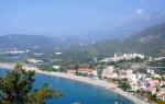
Taganrog Bay is located in the northeastern part of the Sea of Azov and is its largest and most isolated bay. It is separated from the sea by the Dolgaya and Belosarayskaya spits. Its length is about 140 km, width at the entrance is 31 km.
The Taganrog Bay is shallower than the Sea of Azov and has a very smooth bottom topography. As a rule, the water in it freezes from December to March.
The waters of the bay are replenished from the rivers Don, Kalmius, Mius and Eya. These rivers greatly dilute the water in the bay, making it almost fresh, but they also fill it with useful minerals, oxygen and nutrients, creating favorable conditions for many species of fish in Taganrog Bay.
The climate in Taganrog Bay is moderate continental, which makes winters mild and summers comfortable for relaxation. In July, shallow waters warm up to 28 °C, which, combined with gently sloping beaches, makes a holiday on Taganrog Bay suitable for the whole family. The sea remains warm almost until the end of September, extending the velvet season.
Sea air is rich in iodine, various minerals, aromas of steppe herbs and is a natural inhalant. It has a beneficial effect on patients with diseases of the upper respiratory tract (bronchitis, asthma, acute respiratory viral infections, acute respiratory infections).
Holidays in Taganrog are unique in their possibilities. Nature has gathered here a natural “bouquet of health”: warm sea, sun, moderately mild winters and rather hot, dry summers.
The frost-free period is quite long - on average more than 200 days a year, and in warm winters - 240 days.
The waters of Taganrog Bay are warm - the beach season lasts from late May to early September. Storms are extremely rare. The water in the sea is fresh and rarely clear, because... The bottom is muddy in places, there are no jellyfish. To swim, you need to walk 50-100 meters from the shore. In July-August sea water"blooms" - is saturated with tiny green algae rich in iodine.
The Sea of Azov is one of the most productive seas on the globe. Bream, ram, pike perch, sturgeon, bulls, carp, pike, and crucian live here. Crayfish, carp, grass carp and silver carp are successfully bred in ponds, lakes and warm waters of reservoirs. This real paradise for fishing lovers.
Taganrog does not have the usual bustle of resort towns, but there is comfort and tranquility on the seashore.
Details
It is located at the northeastern tip of the Sea of Azov. Its length is 140 km, maximum width is 31 km. It is separated from open space by two spits - Dolgaya and Belosarayskaya.
Thanks to this, as well as the rivers flowing into it, the water here is slightly salty. In its water area there are cities: Taganrog, Mariupol (Ukraine), Yeysk, at a distance of 46 km is Rostov-on-Don, Azov.
History of creation resort area on the Taganrog Bay is closely related to the development of these cities. Favorable combination natural conditions and equipped places of residence contributed to the creation of a recreation area here.
Climate and nature
The region has a temperate continental, mild climate; frosts below 10 °C are very rare. In December - March the bay is covered with ice, only in mild winters does it not freeze.
In summer the temperature reaches 40 °C. The bay warms up quickly, in some years up to 28–30 °C. Bottom sludge is actively used for medicinal purposes.
The bay (the proliferation of green algae) causes obvious inconvenience to resort guests. Only in the south, at a distance of 300–500 m from the coast, powerful currents prevent stagnation and blooming of water.
The flora of the northeastern Azov region consists of wild vegetation, medicinal herbs, forest plantations, cultural and ornamental species of trees and shrubs. An amazingly rich diversity of its species is found on the Beglitsky Spit, which is a protected natural object and is listed in the Red Book.
The fauna is represented by mammals, rodents, and many species of birds, including those living in the coastal zone near water. These are ducks, herons, waders. Freshwater fish species are common. In recent years, due to environmental deterioration, there has been a tendency for salt concentrations to increase; the population of marine fish is beginning to displace freshwater ones.
Rest
The beaches of Taganrog Bay are ideal for sunbathing with the whole family. Their advantage is as follows:
1. Sandy surface and warm water.
2. Gentle entry into a calm sea.
3. Smooth bottom relief.
4. Shallow depth near the shore.
The swimming season lasts all summer until September. The popular sandy beaches of Yeysk are located on the bay. They are landscaped and equipped with all the necessary equipment for classes. water sports and entertainment. Bananas, scooters, catamarans are available, and you can take a stroll on a yacht. There is a rescue service.
In addition, tourists relax in the village of Dolzhanskaya. Some people prefer to stay in tents. There is excellent surfing on the Pavlo-Ochakovskaya spit, and hang gliding on Beglitskaya. Many people like to stay in calm and peaceful Taganrog. The bay looks beautiful from the top of the stone staircase. But comfortable stay both on city and country beaches, is possible only until mid-summer.
Tourists can access nearby inexpensive rural vegetable and fruit markets. Numerous tourist and fishing recreation centers, boarding houses, health institutions, and hotels are concentrated on the shores of the bay.

Magnificent landscapes south sea with seagulls and ships on the horizon. Warm picturesque bay, fresh sea air, sandy beaches will provide complete rest.
Features of Taganrog fishing
Sitting on the shore on a quiet morning with a fishing rod in hand, catching and frying incredibly tasty gobies, or cooking crucian fish soup over a fire is my favorite pastime and the most best entertainment fisherman The season lasts from early spring to early winter. The variety of fish attracts many keen anglers to the bay.
If you sail a considerable distance from the shore, you can catch bream, pike, crucian carp, perch, and pike perch. Near the coast, mainly rams and gobies are caught, the most common prey in these places. There are especially many of them in the middle or at the end of summer, when the bay blooms and is saturated with salts. In some shallow water areas, the catch is counted in buckets.
The tourism and fishing infrastructure of the bay is constantly developing, improving, and filling with interesting entertainment events.