The most amazing places on the planet. The strangest places on earth. Silfra Rift in Iceland
Stunningly beautiful and unusual places of our planet. These surreal landscapes are not from science fiction films, but real places that you can see with your own eyes.
White Desert
Farafra, Egypt
The White Desert (Sahra El Beida) is a relatively small area (300 sq. km) in the east of the Sahara Desert. Once upon a time, a very, very long time ago, there was an ocean floor here and the white desert was the remains of marine microorganisms. Since 2002 this national park Egypt. 

Caño Cristales
Villavicencio, Colombia
The name Caño Cristales River is translated from Spanish as “crystal river”. Because of growing at the bottom different types algae and moss, the river changes its color and therefore the locals call it the “river of five colors”. 


The Wave
Arizona, USA
The Wave are sandstone cliffs located on the Arizona-Utah border. These rocks were formed from sand dunes over millions of years. Minerals oxidized under the influence of groundwater created such amazing colors. 


Marble Cathedral / Capillas de Marmol
Aysen, Chile
The Marble Cathedral is located in Lake General Carrera in Chile. This is a whole network of caves filled with water. On a clear day, sunlight reflects from the water onto the walls, illuminating them and shimmering in different shades. 


Grand Prismatic Spring
Wyoming, USA
Grand Prismatic Spring - the third largest in the world hot spring. It is located in Yellowstone National Park. The spring owes its colors to pigmented bacteria, which are attracted by the abundance of minerals in the water, and change at different times of the year. The depth of the source is 49 meters, and the water temperature near the shore is about 50°C, in the center - 70°C, and at a depth of over 800°C. 


Badlands National Park
South Dakota, USA
Badlands Park is a US national park that literally means “badlands.” The park area was once a river floodplain. The remains of three-toed horses, saber-toothed cats, dog-sized camels, huge pigs and other extinct animals were found here. 


Huanglong Scenic Valley
Sichuan, China
Huanglong means "yellow dragon" in Chinese. Picturesque terraces, or cascades, shimmer in the sun with a golden color and look like dragon scales. The valley was included in the list in 1992 World Heritage UNESCO. 


Gas crater “Gates of Hell” / “Door to Hell” Gas Deposit
Darvaza, Turkmenistan
A gas crater with a diameter of 60 meters and a depth of 20 meters is located in the Karakum Desert. It has been burning continuously for 40 years (since 1971), when during a study by geologists they were drilling an exploration well and the ground collapsed. A crater formed from which gas leaked, and to prevent it from poisoning people, it was decided to set it on fire. 


Atacama Desert
Antofagasta, Chile
The Atacama Desert is the oldest and driest desert in the world. In some areas there has been no rain for years; in some places there has been no rain for hundreds of years. 


Moon Valley / Vale da Lua
Goias, Brazil
Moon Valley is part of national park Chapada dos Veadeiros in Brazil. It is believed that this is the oldest natural formation preserved on Earth. Over thousands of years, rocks consisting of natural quartz have sculpted the waters of the San Miguel River into such bizarre shapes. 


The Great Blue Hole at Lighthouse Reef
Ambergris, Belize
The Great Blue Hole or Great Blue Hole is a perfectly circular sinkhole with a diameter of 305 meters and a depth of 120 meters. 


Geothermal springs in Pamukkale / Pamukkale Thermal Pools
Pamukkale, Türkiye
Pamukkale is a terraced pond formed from travertine, located in Turkey. They were formed as a result of the deposition of salts behind calcium-saturated sources. 


Sossusvlei / Sossusvlei
Khomas, Namibia
Sossusvlei is a clay plateau in the Namib Desert in Africa, which is famous for its world's largest red sand dunes. 


Wai-o-tapu Thermal Wonderland
Rotorua, New Zealand
Wai-O-Tapu means Sacred Waters in Maori. This area of high geothermal activity is home to many geysers, mud lakes and picturesque hot springs. 


The Pinnacles
Cervantes, Australia
The Pinnacles is a small desert in Australia with rocks and cliffs 1-5 meters high rising from the sandy plain. 


Mono Lake
California, USA
Mono Lake is a salt lake in east central California. In the mid-20th century, water from local rivers that fed the lake was redirected to supply water to Los Angeles. Because of this, the lake level dropped sharply by almost 15 meters, exposing the figures that were under water - calcareous tuff, which were formed by mixing calcium from underground flows fresh water and lake carbonates. 


Chocolate Hills
Bohol, Philippines
The Chocolate Hills are a geological formation in the Philippines containing over a thousand hills covered with grass that turns brown during the dry season. 


Giant's Causeway
Northern Ireland, UK
The Giant's Causeway is the territory formed as a result ancient eruption volcano and consists of about 40,000 basalt (less often andesite) columns interconnected. 


Shilin Stone Forest
Yunnan, China
The Shilin Stone Forest was formed from limestone stones ground by water and wind over millions of years. On the territory of the park, total area which is 350 square kilometers, there are not only rocks, but also caves and lakes. 


Socotra Island
Aden, Yemen
Socotra is an island in the state of Yemen with unique flora and fauna that cannot be found anywhere else in the world. Sokotra translated from Sanskrit means “Island of Happiness”. 


During a visit, your skin gets goosebumps from what you see here. With the most scary places We'll get to know each other further on earth.
Old Jewish cemetery in Prague, Czech Republic
Processions in this cemetery took place for almost four centuries (from 1439 to 1787). More than 100 thousand dead are buried on a relatively small plot of land, and the number of gravestones reaches 12,000. More ancient
Cemetery workers covered the burials with earth, and new tombstones were erected in the same place. On the territory of the cemetery there are places where 12 burial tiers are located under the earth's crust. As time passed, the subsided earth revealed old gravestones to the eyes of the living, who began to move later slabs. The view was not only unusual, but also creepy.
Island of Abandoned Dolls, Mexico
There is a very strange abandoned island in Mexico, most of which is inhabited by scary dolls. They say that in 1950, a certain hermit, Julian Santana Barrera, began collecting and hanging dolls from trash cans, who in this way tried to calm the soul of a girl who had drowned nearby. Julian himself drowned on the island on April 17, 2001. Now there are about 1000 exhibits on the island.

Hashima Island, Japan

Hashima is a former coal mining settlement founded in 1887. He was considered one of the most densely populated areas on land - with a coastline of about a kilometer, its population in 1959 was 5,259 people. When coal mining here became unprofitable, the mine was closed and the island city joined the list of ghost towns. This happened in 1974.

Chapel of Bones, Portugal

The Copella was built in the 16th century by a Franciscan monk. The chapel itself is small - only 18.6 meters long and 11 meters wide, but the bones and skulls of five thousand monks are kept here. On the roof of the chapel is written the phrase “Melior est die mortis die nativitatis” (“Better the day of death than the day of birth”).

Suicide Forest, Japan
Suicide Forest is the unofficial name of the Aokigahara Jukai forest, located in Japan on the island of Honshu and famous for the frequent suicides committed there. The forest was originally associated with Japanese mythology and was traditionally thought to be the abode of demons and ghosts. Now it is considered the second most popular place in the world (first at the Golden Gate Bridge in San Francisco) to commit suicide. At the entrance to the forest there is a poster: “Your life is a priceless gift from your parents. Think about them and your family. You don't have to suffer alone. Call us 22-0110."

Abandoned psychiatric hospital in Parma, Italy
Brazilian artist Herbert Baglione created an art piece from a building that once housed a psychiatric hospital. He depicted the spirit of this place. Now ghostly figures of exhausted patients wander around the former hospital.

Church of St. George, Czech Republic

The church in the Czech village of Lukova has been abandoned since 1968, when part of its roof collapsed during a funeral ceremony. Artist Jakub Hadrava populated the church with ghost sculptures, giving it a particularly sinister look.

Catacombs in Paris, France

The Catacombs are a network of winding underground tunnels and caves beneath Paris. The total length, according to various sources, is from 187 to 300 kilometers. Since the end of the 18th century, the remains of almost 6 million people have been buried in the catacombs.

Centralia, Pennsylvania, USA
Due to an underground fire that broke out 50 years ago and continues to burn to this day, the number of residents has decreased from 1,000 people (1981) to 7 people (2012). Centralia now has the smallest population in the state of Pennsylvania. Centralia served as the prototype for the creation of the city in the Silent Hill series of games and in the film based on this game.

Magic Market Akodessewa, Togo

The Akodesseva market for magical items and witchcraft herbs is located right in the center of the city of Lome, the capital of the state of Togo in Africa. Africans of Togo, Ghana and Nigeria still practice the voodoo religion and believe in the miraculous properties of dolls. Akodesseva's fetish assortment is extremely exotic: here you can buy cattle skulls, dried heads of monkeys, buffalos and leopards and many other equally “wonderful” things.

Plague Island, Italy
Poveglia is one of the most famous islands Venetian lagoon, northern Italy. It is said that since Roman times the island was used as a place of exile for plague patients, and therefore up to 160,000 people were buried on it. The souls of many of the dead allegedly turned into ghosts, with which the island is now filled. The island's dark reputation is compounded by stories of horrific experiments allegedly carried out on psychiatric patients. In this regard, paranormal researchers call the island one of the most terrible places on the ground.

Hill of Crosses, Lithuania
The Mountain of Crosses is a hill on which many Lithuanian crosses are installed, their total number is approximately 50 thousand. Despite the external resemblance, it is not a cemetery. According to popular belief, good luck will accompany those who leave a cross on the Mountain. Neither the time of the appearance of the Mountain of Crosses nor the reasons for its appearance can be said with certainty. To this day, this place is shrouded in secrets and legends.

Burials of Kabayan, Philippines
The famous fire mummies of Kabayan, dating back to 1200-1500 AD, are buried here, as well as, as local residents believe, their spirits. They were made using a complex mummification process, and are now carefully guarded, as cases of their theft are not uncommon. Why? As one of the robbers said, “he had the right to do this,” since the mummy was his great-great-great-great-great-great-great-grandfather.

Overtoun Bridge, Scotland

Old arch bridge is located near the Scottish village of Milton. In the middle of the 20th century, strange things began to happen on it: dozens of dogs suddenly threw themselves from a 15-meter height, fell onto rocks and were killed. Those that survived came back and tried again. The bridge has turned into a real “killer” of four-legged animals.

Actun-Tunichil-Muknal Cave, Belize

Actun Tunichil Muknal is a cave near the city of San Ignacio, Belize. It is an archaeological site of the Mayan civilization. Located on the territory natural park Mount Tapira. One of the halls of the cave is the so-called cathedral, where the Mayans made sacrifices, as they considered this place to be Xibalba - the entrance to the underworld.

Leap Castle, Ireland
Leap Castle in Offaly, Ireland is considered one of the cursed castles in the world. Its gloomy attraction is a large underground dungeon, the bottom of which is studded with sharp stakes. The dungeon was discovered during the restoration of the castle. In order to remove all the bones from it, the workers needed 4 carts. Locals the castle is said to be haunted by many ghosts of people who died in the dungeon.

Chauchilla Cemetery, Peru
The Chauchilla Cemetery is located about 30 minutes from the Nazca desert plateau, on south coast Peru. The necropolis was discovered in the 20s of the twentieth century. According to researchers, bodies found in the cemetery are about 700 years old, and the last burials here took place in the 9th century. Chowchilla differs from other burial sites in the special way in which people were buried. All the bodies are “squatting”, and their “faces” seem to be frozen in a wide smile. The bodies were perfectly preserved thanks to the Peruvian dry desert climate.

Sanctuary of Tophet, Tunisia

The most notorious feature of Carthage's religion was the sacrifice of children, mainly infants. During the sacrifice it was forbidden to cry, since it was believed that any tear, any plaintive sigh would detract from the value of the sacrifice. In 1921, archaeologists discovered a site where several rows of urns were found containing the charred remains of both animals (they were sacrificed instead of people) and small children. The place was called Tophet.

Snake Island, Brazil
Queimada Grande is one of the most dangerous and famous islands of our planet. There is only a forest, a rocky, inhospitable coast up to 200 meters high, and snakes. There are up to six snakes per square meter of the island. The poison of these reptiles acts instantly. Brazilian authorities have decided to completely ban anyone from visiting the island, and locals are telling chilling stories about it.

Buzludzha, Bulgaria

The largest monument in Bulgaria, located on Mount Buzludzha with a height of 1441 meters, was built in the 1980s in honor of the Bulgarian Communist Party. Its construction took almost 7 years and involved more than 6 thousand workers and experts. The interior was partly decorated with marble, and the staircases were decorated with red cathedral glass. Now the monument house has been completely looted, only a concrete frame with reinforcement remains, looking like a destroyed alien ship.

City of the Dead, Russia

Dargavs in North Ossetia looks like a cute village with small stone houses, but in fact it is an ancient necropolis. People were buried in various types of crypts along with all their clothing and personal belongings.

Abandoned military hospital Beelitz-Heilstetten, Germany
During the First and Second World Wars the hospital was used by the military, and in 1916 Adolf Hitler was treated there. After World War II, the hospital found itself in the zone of Soviet occupation and became the largest Soviet hospital outside the USSR. The complex consists of 60 buildings, some of which have now been restored. Almost all abandoned buildings are closed to access. The doors and windows are securely boarded up with high boards and sheets of plywood.

Unfinished subway in Cincinnati, USA
Abandoned subway depot in Cincinnati - project built in 1884. But after the First World War and as a result of changing demographics, the need for the metro disappeared. Construction slowed in 1925, with half of the 16 km line completed. The abandoned subway now hosts tours twice a year, but many people are known to wander its tunnels alone.

Hanging Coffins of Sagada, Philippines

On the island of Luzon, in the village of Sagada, there is one of the most frightening places in the Philippines. Here you can see unusual funeral structures made of coffins placed high above the ground on the rocks. There is a belief among the indigenous population that the higher the body of the deceased is buried, the closer his soul will be to heaven.

Nuclear lighthouse at Cape Aniva (Sakhalin)
The lighthouse was built with great difficulty in 1939 according to the design of the architect Miura Shinobu - it was a unique and most complex technical structure in all of Sakhalin. It operated on a diesel generator and battery backup until the early 1990s, when it was refurbished. Thanks to the nuclear energy source, maintenance costs were minimal, but soon there was no money left for this either - the building was empty, and in 2006 the military removed two isotope installations that powered the lighthouse from here. It once shone for 17.5 miles, but is now plundered and abandoned.

Eighth workshop of the Dagdizel plant, Makhachkala
Naval weapons testing station, commissioned in 1939. It is located 2.7 km from the coast and has not been used for a long time. Construction took a long time and was complicated by difficult conditions. Unfortunately, the workshop did not serve the plant for long. The requirements for the work carried out in the workshop changed, and in April 1966 this grandiose structure was written off from the factory balance sheet. Now this “Array” is abandoned and stands in the Caspian Sea, resembling an ancient monster from the shore.

Lier Sikehus Psychiatric Clinic, Norway
The Norwegian psychiatric hospital, located in the small town of Lier, half an hour's drive from Oslo, has a dark past. Once upon a time, experiments were carried out on patients here, and unknown reasons four buildings of the hospital were abandoned in 1985. Equipment, beds, even magazines and personal belongings of patients remained in the abandoned buildings. At the same time, the remaining eight buildings of the hospital are still operating to this day.

Gunkanjima Island, Japan
In fact, the island is called Hashima, nicknamed Gunkanjima, which means “cruiser island.” The island was settled in 1810 when coal was discovered there. Within fifty years, it has become the most populated island in the world in terms of the ratio of land and the number of inhabitants on it: 5,300 people with a radius of the island itself of one kilometer. By 1974, the reserves of coal and other minerals on Gankajima were completely exhausted, and people left the island. Today, visiting the island is prohibited. There are many legends about this place among the people.

We present the most Beautiful places of our country, which should be seen not only by every photographer and traveler, but also by every resident of our vast Russia. Read our material and you will see: we all have something to be proud of!
Natural parks, reserves
Lena Pillars, Yakutia
Lena Pillars is a natural park in Russia, located on the banks of the Lena River in the Khangalassky ulus of Yakutia, 104 km from the city of Pokrovsk. Stretching for many kilometers, the complex of vertically elongated rocks, intricately piled up along the banks of the Lena, cutting through the Prilenskoye Plateau with a deep valley, never ceases to attract photographers and travelers. The pillars reach their greatest density between the villages of Petrovskoye and Tit-Ary.
The height of the rock formations reaches 100 meters. Scientists believe that the formation of rocks began 560–540 million years ago, and the formation of the Lena Pillars as a landform began about 400 thousand years ago.
The Lena Pillars Natural Park was organized on the basis of the decree of the President of the Republic of Sakha (Yakutia) dated August 16, 1994 No. 837 and the government decree of February 10, 1995 and is subordinate to the regional Ministry of Nature Protection. The area of the park is 485 thousand hectares, the park consists of two branches - “Stolby” and “Sinsky”.
Valley of Geysers, Kamchatka

The Valley of Geysers, one of the largest geyser fields in the world and the only one in Eurasia, is located in Kamchatka in the Kronotsky State biosphere reserve, which is on the UNESCO World Heritage List as part of the natural complex “Volcanoes of Kamchatka”.
The valley represents deep canyon of the Geysernaya River, on the sides of which an area of about 6 square meters. km there are numerous outlets of geysers, hot springs, mud pots, thermal areas, waterfalls and lakes. In this territory there is an abnormally high biodiversity and a high contrast of natural conditions and microclimate. The ecosystem of the Valley of Geysers is unique throughout the country. The territory of the valley is protected by a reserve regime.
Since 1992, under an agreement with the reserve, helicopter excursions have been organized here, and there is a strict system of rules for organizing excursions in order to maintain the balance of the ecosystem. In 2008, based on voting results, the Valley of Geysers was included in the list of seven wonders of Russia.
Weathering pillars, Komi Republic

Weathering pillars (Mansi logs) are a geological monument located in the Troitsko-Pechora region of the Komi Republic on the territory of the Pechora-Ilychsky Nature Reserve on Mount Man-Pupu-ner (“ Malaya Gora idols" translated from the Mansi language), in the interfluve of the Ichotlyag and Pechora rivers. Many legends are associated with this extraordinary place. The pillars are considered one of the seven wonders of Russia.
The weathering pillars are located quite far from inhabited places. Reaching them is in some sense a feat. To do this, by the way, you need to obtain a pass from the administration of the reserve. From the Sverdlovsk region and Perm region there is walking route, from the Komi Republic side - automobile, water and walking routes.
About 200 million years ago, in place of the stone pillars there were high mountains. Rain, snow, wind, frost and heat gradually destroyed the mountains, and especially weak rocks. Hard sericite-quartzite shales were less destroyed and have survived to this day, while soft rocks were destroyed by weathering and carried by water and wind into relief depressions.
One pillar, 34 m high, stands somewhat apart from the others. Six others lined up at the edge of the cliff. The pillars have bizarre outlines and, depending on the place of inspection, resemble either the figure of a huge man, or the head of a horse or ram. It’s true: this place is ideal for a photographer’s imagination! In past times, the Mansi deified grandiose stone sculptures and worshiped them, but climbing Manpupuner was considered the greatest sin.
Curonian Spit, Kaliningrad region

The Curonian Spit is a sand spit located on the coast of the Baltic Sea and the Curonian Lagoon. It is a narrow and long saber-shaped strip of land separating the Curonian Lagoon from the Baltic Sea and stretching from the city of Zelenogradsk in the Kaliningrad region to the city of Klaipeda (Smiltyne) (Lithuania). The name of the spit comes from the name of the ancient Curonian tribes who lived here before the colonization of Prussia by the Germans.
The length is 98 kilometers, the width ranges from 400 meters (in the area of the village of Lesnoy) to 3.8 kilometers (in the area of \u200b\u200bCape Bulviko, just north of Nida).
The Curonian Spit is a unique natural-anthropogenic landscape and a territory of exceptional aesthetic value: the Curonian Spit is the largest sand body, included, along with the Hel and Vistula, in the Baltic complex of sand spits, which has no analogues in the world. The high level of biological diversity due to the combination of different landscapes - from desert (dunes) to tundra (raised bog) - provides insight into important and long-term ecological and biological processes in evolution.
The most significant element of the spit's relief is a continuous strip of white sand dunes 0.3 - 1 km wide, some of them approaching the highest in the world (up to 68 m). Thanks to his geographical location and orientation from northeast to southwest, it serves as a corridor for migratory birds of many species flying from the northwestern regions of Russia, Finland and the Baltic countries to the countries of the Middle and Southern Europe. Every year in spring and autumn, from 10 to 20 million birds fly over the spit, a significant part of which stop here to rest and feed.
Favorable climatic conditions allow you to relax on the Curonian Spit from May to November. In 2000, the Curonian Spit was included in the UNESCO World Heritage List.
Nature reserve "Stolby". Krasnoyarsk region

The reserve is located on the northwestern spurs of the Eastern Sayan Mountains, bordering the Central Siberian Plateau. The natural boundaries of the protected area are the right tributaries of the river. Yenisei: in the northeast - the Bazaikha river, in the south and southwest - the Mana and Bolshaya Slizneva rivers. From the northeast, the territory borders the city of Krasnoyarsk; the border of the reserve can be reached by bus. The reserve was founded in 1925 on the initiative of city residents to preserve natural complexes around the picturesque syenite outcrops - “pillars”. Currently, its area is 47,219 hectares. Submitted to the UNESCO World Heritage List.
Lakes
Lake Baikal, Eastern Siberia

It’s unlikely that Baikal needs any descriptions, but still... Baikal is the deepest lake on the planet, the largest natural reservoir of fresh water. The lake and coastal areas are distinguished by a unique diversity of flora and fauna. Local residents and many in Russia traditionally call Baikal the sea.
The maximum depth of the lake - 1642 m - was established in 1983 by L. G. Kolotilo and A. I. Sulimov during hydrographic work. The average depth of the lake is also very large - 744.4 m. Besides Baikal, only two lakes on Earth have a depth of more than 1000 meters: Tanganyika (1470 m) and the Caspian Sea (1025 m). One of the visiting cards of Russia, a place that you need to see with your own eyes at least once in your life!
Lake Seliger, Tver and Novgorod regions

Another place that needs no introduction. By the way, Seliger has another name - Ostashkovskoye Lake, after the name of the city of Ostashkov, located on the lake shore. The area of the lake is 260 sq. km, including about 38 sq. km. km there are islands (there are more than 160 of them on Seliger). The largest among them is Khachin Island. The area of the entire pool is 2275 sq. km.
Seliger receives 110 tributaries. The largest are the Krapivenka, Soroga and Seremukha rivers. Only one river, Selizharovka, flows out of it. The lake lies at an altitude of 205 meters above sea level and is of glacial origin. This explains its peculiar shape - it is not a lake in the usual concept, but rather a chain of lakes stretching from north to south for 100 km and connected by short narrow channels. The coastline, more than 500 km long, is rugged - forested headlands, deep picturesque bays jutting into the land, and islands of various shapes.
The water in Seliger is clear, transparency reaches 5 meters. On the shore of the southern part of Lake Seliger are the city of Ostashkov and the New Yeltsy estate.
Lake Kezenoy-am, Chechen Republic

Kezenoy-am is a lake on the border of the Vedeno region of the Chechen Republic and the Botlikh region of Dagestan. This is the largest and deepest lake North Caucasus, located at an altitude of more than 1800 meters above sea level. The surface of the lake is 2.4 sq. km.
The depth of the lake reaches 74 m. The length of the lake from north to south is 2 kilometers, and from west to east - 2.7 kilometers. The maximum width is 735 meters. The length of the coastline is 10 kilometers.
Lake Baskunchak
Akhtubinsky district, Astrakhan region

Baskunchak - salt Lake, having an area of about 115 sq. km in the Akhtubinsky district of the Astrakhan region, approximately 270 km north of the Caspian Sea, and 53 km east of the Volga. Lake Baskunchak is part of a unique natural complex that includes Mount Big Bogdo. In 1997, the Bogdinsko-Baskunchaksky natural complex was declared a reserve (Bogdinsko-Baskunchaksky Nature Reserve), where a special environmental regime was established on an area of 53.7 thousand hectares.
On the coast of the lake there are deposits of medicinal clays. In June-August, tourists come to the lake to bathe in brine and take mud baths. There is no need to talk about the beauty of these places. There are no fewer photographers here than people who want to improve their health.
Jack London Lake, Magadan Region

Located in the upper reaches of the Kolyma River in the Yagodninsky district of the Magadan region, it lies among the mountains, at an altitude of 803 meters, the length of the lake in the northwest direction is 10 kilometers, depth is 50 meters.
There are many small lakes around Jack London Lake. The most prominent lakes in size are lakes Mechta, Anemone, Gray Chaika, Nevidimka, Neighboring, and Kudinovskie lakes. One of the most beautiful and exotic lakes Far East. Old-timers say that the lake got its name thanks to an unusual find made by the “discoverers”. When the lake was discovered, researchers found Jack London's book "Martin Eden" on the shore.
Lake Elton, Volgograd region

Elton is a salty, drainless, self-sedating lake in the Pallasovsky district of the Volgograd region, located near the border with Kazakhstan. It is considered the largest mineral lake in Europe and one of the most mineralized in the world. They say that the name of the lake comes from the Mongolian word “Altyn-Nor” - “golden bottom”.
Lake area - 152 sq. km. Until 1882, salt was mined on Elton; in 1910, a medical sanatorium"Elton" (moved to a new location in 1945). In 2001, the lake and the adjacent territories of virgin steppes (106 thousand hectares) became part of the State Institution “Eltonsky Natural Park”.
Blue Lakes. Cherek-Balkarian Gorge, Kabardino-Balkaria

A group of five karst lakes in the Cherek region of Kabardino-Balkaria is located at the foot of the rocky ridge from where the Cherek-Balkarian gorge begins. Located at the entrance to the gorge, Blue Lake is a unique a natural phenomenon, interesting not only for Kabardino-Balkaria, but also on a national scale. The Lower Blue Lake has several names: Chirik-kel (bulk) - rotten (smelly) lake; Sherej-ana (kab.) - Cherek’s mother; Psykhurey (kab.) - round water (lake), natural artesian well.
The uniqueness of Nizhny blue lake is that with a relatively small surface (only 235×130 m), its depth reaches 258 meters. The surface water temperature in winter and summer is about +9 degrees. Not a single stream or river flows into the lake, but about 70 million liters flow out every day. The lake level remains unchanged, which is explained by powerful underwater sources. The blue color of the water is due to the presence of hydrogen sulfide and the refraction of light rays in the deep pool.
The nature here is quite picturesque: green hills, dense beech forests on steep slopes, and in the distance, in the blue haze, peaks sparkling in the sun. Closer to Babugent the greenery becomes brighter and juicier. Near the village of Babugent there is a fork in the road. At the beginning of the road to the lake, in the rock there is a cave in which traces of an ancient site of the 5th-10th centuries AD were discovered. Now many bats live there, and sometimes, in bad weather, shepherds with flocks of sheep take shelter.
Seydozero, Kola Peninsula, Murmansk region

Lake in the Lovozero tundra on the Kola Peninsula. "Seid" translated from the Sami language means "sacred". The lake is located at an altitude of 189 m above sea level. The length of Seydozero is 8 km, width is from 1.5 to 2.5 km.
According to a number of science fiction writers and ufologists, it is one of the supposed places of existence of the Hyperborean civilization. Seekers of the unknown have been exploring these places since 1922.
Lake (reservoir) Zyuratkul. Chelyabinsk region

Zyuratkul is located in Satka district Chelyabinsk region on the territory of the national park of the same name. One of the highest (724 m above sea level) reservoirs in the Southern Urals. The reservoir is surrounded by mountain ranges covered with dark coniferous forests. To the southwest is the Nurgush ridge - the highest ridge in the Chelyabinsk region. The main river feeding the reservoir is the Bolshoi Kyl. Near the source of the Satka River and the dam there is the small village of Zyuratkul, connected by bus to the city of Satka.
Previously, Zyuratkul was a natural lake. Now it is a reservoir formed by a dam built on Bolshaya Satka. A giant geoglyph was found in the lake area. About forty stone tools made of quartzite were also discovered. The technique of stone chipping makes it possible to date the tools to the Neolithic and Chalcolithic (VI-III millennium BC). Researchers are still inclined to the Copper-Stone Age (IV-III millennium BC). It is noted that at that time Southern Urals there were practically no forests (they appeared only 2,500 years ago), so the figure was easy to construct and then view from the neighboring ridge until it was covered with a layer of soil.
Until the winter of 2012, another popular attraction was located on the shore of Lake Zyuratkul - Whale Pier, which was also called the “Ural Disneyland”. But in the fall of 2012, by court order, it was demolished.
Mountains and volcanoes
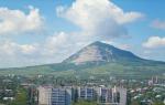
Elbrus, Kabardino-Balkaria

Elbrus is a stratovolcano located on the border of the republics of Kabardino-Balkaria and Karachay-Cherkessia. Elbrus is located north of the Greater Caucasus Range and is the highest peak in Russia. Considering that the border between Europe and Asia is ambiguous, Elbrus is often also called the highest European mountain peak, thereby classifying it as one of the “Seven Summits”.
The height of the western peak is 5642 m, the eastern one is 5621 m. The Adylsu, Shkheldy, Adyrsu gorges, the Donguz-Oruna and Ushba massifs are very popular among climbers and mountain tourists. The Elbrus region is the most popular ski resort Russia. The total area of Elbrus glaciers is 134.5 square meters. km. The most famous of them: Big and Small Azau, Terskol.
Altai Mountains

The Altai Mountains represent a complex system of the highest ridges in Siberia, separated by deep river valleys and vast intramountain and intermountain basins. A mountain system at the junction of the borders of Russia, Mongolia, China and Kazakhstan. It is divided into Southern Altai (Southwestern), Southeastern Altai and Eastern Altai, Central Altai, Northern and Northeastern Altai, Northwestern Altai.
The Altai, Katunsky reserves and the Ukok plateau together form the UNESCO World Heritage Site “Altai - Golden Mountains”. Thousands of tourists come to Altai. This is a favorite place for photo tours and independent trips.
Divnogorye plateau, Liskinsky district, Voronezh region

“Divnogorye” is a hill and museum-reserve in the Liskinsky district of the Voronezh region of Russia. It is located 10 km west of the center of the region on the right bank of the Don River and 80 km south of Voronezh. The museum here was founded in 1988, and in 1991 it received the status of a museum-reserve. Currently, the museum-reserve is one of the most popular and most recognizable attractions in the Voronezh region. Every season, from May to October, it is visited by more than 60 thousand tourists.
The area of the museum-reserve is more than 11 sq. km. The maximum height of the plateau above sea level reaches 181 meters, relative - 103 meters (the mouth of the Tikhaya Sosna River at the confluence with the Don, which flows at the foot of the plateau, is located at an altitude of 78 m above sea level).
Dombay-Ulgen, Karachay-Cherkess Republic

Dombay-Ulgen is the top of the western part of the Watershed Range of the Greater Caucasus (on the border of Abkhazia and the Karachay-Cherkess Republic). Dombay-Ulgen is the highest peak in Abkhazia, located east of the village of Dombay, has three peaks: western (4036 m), main (4046 m) and eastern (3950 m).
A steep ridge extends from the main peak to the north, ending in a depression - the “Dombay saddle”. From the Dombay saddle there is a classic route (category 3B), which can be climbed in one day with a descent to the camp.
Putorana Plateau, Krasnoyarsk Territory

The Putorana Plateau is a mountain range located in the north-west of the Central Siberian Plateau. In the north and west, the plateau ends with a steep ledge (800 m or more), while the southern and eastern parts are characterized by gentle slopes. The maximum height of the plateau is 1701 m, among the highest peaks are Mount Kamen (1701 m), Kholokit (1542 m), Kotuyskaya (1510 m). In the north, the Putorana Plateau borders the Taimyr Peninsula. The name Putorana translated from Evenki means “lakes with steep banks.”
The area of the plateau is 250 thousand sq. km, which is comparable to the territory of Great Britain. On the territory of the plateau is the Putorana State nature reserve, recognized by UNESCO as a World Heritage Site.
Marble Canyon Ruskeala, Republic of Karelia, Ruskeala village

Mountain Park "Ruskeala" is a tourist complex located in the Sortavala region of the Republic of Karelia, near the village of Ruskeala. The main object of the complex is a former marble quarry filled with groundwater.
The quarries discovered by Pastor Alopeus began to be developed at the beginning of the reign of Catherine II. The first developments were led by Captain Kozhin, who was advised by Italian specialists. Today, the length of the quarry from north to south is 460 meters, the width is up to 100 meters. The distance from the highest point of the quarry side to its bottom is over 50 meters. Water transparency reaches 15-18 meters.
Ruskeala marble was used in the construction of the most beautiful and significant buildings of St. Petersburg and its palace suburbs. Lined with it Saint Isaac's Cathedral, the floors of the Kazan Cathedral were laid out, the window sills of the Hermitage were made, the windows of the Marble Palace and the facade of the Mikhailovsky Castle were framed, as well as the underground halls of the St. Petersburg metro stations “Primorskaya” and “Ladozhskaya”. In 2010, a significant part of the filming of the film “The Dark World” took place in Ruskeala.
Eastern and Western Sayans. Eastern Siberia

The Eastern and Western Sayans are the common name for two mountain systems in southern Siberia. There are Western Sayan (length 650 km, height up to 3971 m - Mount Mongun-Taiga, which is the top of the ridge of the same name - highest peak Eastern Siberia, however, more often this ridge is not classified as the Sayan Mountains, but is classified as a separate mountain system- Tuva Mountains), consisting of leveled and pointed ridges, on which there is no glaciation, separated by intermountain basins, and the Eastern Sayan (length about 1000 km, height up to 3491 m - Mount Munku-Sardyk) with typical mid-mountain ridges bearing glaciers. The rivers belong to the Yenisei basin. The slopes are dominated by mountain taiga, turning into mountain tundra.
The Western Sayan borders Altai in its southwestern part. Main Ridge its - the Watershed Sayan Range with its highest point - Mount Kyzyl-Taiga (3121 m). The Western Sayan ridges are characterized by steep slopes, rugged terrain, and vast areas of stone placers. The height of the ridges in the west does not exceed 2500-3000 m, to the east it decreases to 2000 m.
The Eastern Sayan stretches almost at right angles to the Western Sayan. Its ridges form a system of “Belogory” (Manskoye, Kanskoye) and “belkov”, which got their name because of the snow on the peaks that does not melt all year round. In the central part, in the upper reaches of the Kazyr and Kizir rivers, several ridges form a “knot” with the highest point - the Grandiozny peak (2982 m). In the southeast are the highest and most inaccessible ranges - the Bolshoy Sayan, Tunkinskie Goltsy, Kitoiskie Goltsy, Kropotkin. The highest point of the Eastern Sayan - Munku-Sardyk (3491 m) is located in the ridge of the same name. Between the Sayan ridges there are more than a dozen basins of various sizes and depths, the most famous of which is the Abakan-Minusinsk basin, known for its archaeological sites. It is worth noting a large number of waterfalls.
Almost everywhere in the Sayan Mountains, dark coniferous taiga spruce-cedar-fir forests prevail, rising in the western and central parts up to altitudes of 1500–1800 m and more; light deciduous cedar forests form the upper border of the forest at altitudes of 2000–2500 m. Animal world as rich as vegetable. The largest city, located in Sayany - Krasnoyarsk.
Shikhany Mountains. Republic of Bashkortostan

Shikhany are isolated hills in the Bashkir Cis-Urals, consisting of four single mountains: Tratau, Shakhtau, Yuraktau and Kushtau, which form a narrow chain stretched along the Belaya River for 20 km. Shihans are located near the cities of Sterlitamak and Ishimbay. They are unique monuments nature - the remains of a barrier reef formed in the warm sea of the early Permian period. The stones from which these shikhans are made contain imprints of ancient plants and animals.
The highest shihan is Tratau (or Toratau). Its height is 402 meters above sea level, and its relative height is 280 meters. At its foot are the ruins of a women's prison - one of the islands of the Gulag archipelago. Shikhan Tratau flaunts on the coat of arms of the city of Ishimbay, is a symbol of the Ishimbay region of Bashkiria. In the past, this mountain was considered sacred.
Volcano Krenitsyn. Sakhalin region, Onekotan island

An active volcano on Onekotan Island in the Great Kuril Ridge. The largest two-tiered “volcano within a volcano” in the world is located in the southern part of Onekotan Island. The height of the volcano is 1324 m.
The volcanic cone rises in the form of an island inside Lake Koltsevoye, which lies at an altitude of 400 m (diameter about 7 km). The lake is surrounded by a somma - the walls of the more ancient Tao-Rusyr caldera (heights 540–920 m with a base diameter of 16–17 km).
There is only one known historical eruption, which occurred in 1952.
Volcano Tyatya, Kuril Islands

An active volcano on the Kunashir Island of the Great Kuril Ridge, on the territory of the Kuril Nature Reserve. In geographical terms, Tyatya is a stratovolcano of the somma-vesuvius type (“volcano within a volcano”). The height reaches 1819 m (the highest point of Kunashir; in 1977 and subsequent years, the south-eastern part of the edge of the summit crater collapsed and most of the material fell inside the north-eastern crater. As a result of this, the total height of the volcano decreased by about 30-50 meters and is currently probably less than 1800 meters above sea level)..
The height of the somma is 1485 m, it has a regular truncated cone with a diameter of 15–18 km at the base and up to 2.5 km at the annular ridge. The foothills of the volcano are decorated with coniferous-deciduous forests with bamboo and thickets of stone birch and dwarf cedar. In the forests at the foot you can often find a bear. The path to the volcano is difficult, but most tourists get to the volcano from Yuzhno-Kurilsk.
Caves
Orda Cave, Perm region

The Orda Cave is located on the southwestern outskirts of the village of Orda, Perm Territory, on the left bank of the Kungur River. Consists of a “dry” and underwater part. The length of the dry part is 300 meters, the underwater part is 4600 meters. Today, Orda Cave is the longest flooded cave in Russia. In addition, part of the cave is the longest siphon in the CIS - 935 meters.
The cave ranks 21st among the longest gypsum caves in the world. Famous photographer Viktor Lyagushkin dedicated an entire photo project to the Orda Cave.
Kungur Cave, Perm region

This is one of the most popular attractions in Siberia and the Urals, a natural monument of all-Russian significance. The cave is located in Perm region, on the right bank of the Sylva River on the outskirts of the city of Kungur in the village of Filippovka, 100 km from Perm.
A unique geological monument - one of the largest karst caves in the European part of Russia, the seventh longest gypsum cave in the world. The length of the cave is about 5700 m, of which 1.5 km is equipped for visits by tourists. The average air temperature in the center of the cave is +5 °C, the relative humidity in the center of the cave is 100%. The Kungur cave contains 58 grottoes, 70 lakes, 146 so-called. “organ pipes” (the highest is in the Ethereal Grotto, 22 m) - high shafts reaching almost to the surface.
Architecture
Nevyansk Leaning Tower. Sverdlovsk region, Nevyansk city

Not everyone knows that in Russia we have our own version of the Leaning Tower of Pisa - a leaning tower in the center of Nevyansk, built in the first half of the 18th century by order of Akinfiy Demidov.
The height of the tower is 57.5 meters, the base is a square with a side of 9.5 m. The deviation of the tower from the vertical is about 1.85 m, with the greatest inclination observed at the lower tier (3 ° 16"). The exact date of construction of the tower is unknown, different sources give dates ranging from 1721 to 1745.
The tower is a massive quadrangle, with 3 octagonal tiers built on top. Inside, the tower is divided into several levels - floors.
The purpose of the first floor is not precisely established. Demidov's office was located on the second floor, and during Soviet times it was a prison. On the third floor there was a laboratory: traces of silver and gold were found in the soot taken from the chimneys of the furnaces. According to one version, Demidov minted counterfeit money here. According to another, here Demidov, secretly from the state treasury, smelted silver and gold, which was mined at his mines in Altai.
Even higher is the so-called “auditory room”. Its peculiarity is that standing in one corner of the room, you can clearly hear what is being said in the opposite corner. The effect observed in the room is associated with the special shape of the ceiling - it is vaulted and at the same time slightly flattened.
On the seventh and eighth floors there are chimes with musical chimes, created by the English watchmaker Richard Phelps in 1730. The tower is completed by a roof and a metal spire with a weather vane mounted on it, made of milled iron, in which the noble coat of arms of the Demidovs is embossed.
There is a legend that the tower tilted because the basements were flooded with all the workers minting counterfeit money. By Resolution of the Council of Ministers of the RSFSR No. 1327 of August 30, 1960, the tower was included in the list historical monuments, subject to protection as monuments of national importance.
Ivolginsky datsan. Republic of Buryatia, village of Verkhnyaya Ivolga

Ivolginsky datsan is a large Buddhist monastery complex, the center of the Buddhist traditional Sangha of Russia, which is the largest Buddhist community in Buryatia. One of the most striking monuments of Russian history and architecture. Located in the village of Verkhnyaya Ivolga, 36 km from the center of Ulan-Ude.
Bird home. Republic of Crimea

Among all the attractions of Crimea, it is not easy to choose just one. But we decided to stop at one of the most inspiring places. Swallow's Nest is an architectural and historical monument located on the steep 40-meter Aurora rock of Cape Ai-Todor in the village of Gaspra (Yalta City Council).
The structure resembles a medieval knight's castle like the Belem Tower or Villa Miramare near Trieste. The first wooden structure on this site was erected for a retired Russian general after the Russian-Turkish War of 1877–1878; it can be seen on the canvases of famous marine painters: I.K. Aivazovsky, L.F. Lagorio, A.P. Bogolyubov, and also in photographs from that time.
The second owner of this amazing dacha was the court physician A.K. Tobin. There is also very little information left about him. After his death, the house was owned for some time by a widow, who sold the plot to the Moscow merchant Rakhmanina. She demolished the old building, and soon a wooden castle appeared, which she called “Swallow’s Nest.”
“Swallow’s Nest” received its current appearance thanks to the oil industrialist Baron Steingel, who loved to vacation in Crimea. Steingel purchased a summer cottage on Aurora Rock and decided to build a romantic castle there, which is reminiscent of medieval buildings on the banks of the Rhine. The design of the new house was commissioned from engineer and sculptor Leonid Sherwood, son of architect Vladimir Sherwood, author Historical Museum on Red Square in Moscow.
At the beginning of the First World War, the estate was bought by the Moscow merchant P. Shelaputin, who opened a restaurant in the castle. In the 1930s, there was a reading room here at the local holiday home, but the premises were considered unsafe and closed.
In 1927, Swallow's Nest was damaged during strong earthquake. Only in 1967–1968 were repairs carried out. In addition to the monolithic slab, the entire structure was surrounded by anti-seismic belts. The tower, increased in height, became more decorative thanks to its four spiers. In 2013, cracks were discovered in the foundation slab, and in the fall the visit was suspended for design work to carry out reconstruction - strengthening the rock.
And 6 more amazing places:
Chara Sands, Transbaikal region

Chara Sands is a tract in the Kalarsky district of the Trans-Baikal Territory, which is a sandy massif measuring approximately 10 km by 5 km. Chara sands are located in the basin of the same name, in the foothills of the Kodar ridge, 9 kilometers from the village of Chara, between the valleys of the Chara, Middle Sakukan and Upper Sakukan rivers. The massif is a geological natural monument of geomorphological type of federal rank.
BAM station Novaya Chara is 10 kilometers away. The massif stretches from southwest to northeast and covers an area of about 50 sq. km. In no other basin of Transbaikalia are there such large massifs of loose moving sands. Chara sands are similar in appearance to the deserts of Central Asia. The vegetation is slightly different from the taiga: there are areas with larches, dwarf birches and moisture-loving dwarf cedar. In the northeastern part of the tract there are two small lakes - Alyonushka and Tayozhnoe.
Avachinskaya Bay, Kamchatka Territory

Avachinskaya Bay is a large ice-free bay of the Pacific Ocean off the south-eastern coast of the Kamchatka Peninsula, and is the main transport “gate” of the Kamchatka Territory. The main advantage of the bay is that it is one of the largest bays in the world: it can accommodate any ship in the world!
The length of the bay is 24 kilometers, the width at the entrance is 3 kilometers, the total area of the water surface is 215 sq. km. Depth up to 26 meters. The Avacha and Paratunka rivers flow into the bay. The cities of Petropavlovsk-Kamchatsky and Vilyuchinsk are located along the shores of the bay. The bay is the main base of the Russian Pacific Fleet in Kamchatka.
A unique symbol of the bay and its landmark are the Three Brothers rocks, located at the exit to the open Avacha Bay.
Commander Islands. Aleutsky district, Kamchatka region

Commander Islands - an archipelago of four islands in the southwestern part of the Bering Sea of the Pacific Ocean, administratively part of the Aleutian region of the Kamchatka Territory of Russia. The islands are named after the navigator Commander Vitus Bering who discovered them in 1741. On the largest of them, Bering Island, there is the navigator’s grave. The Commander Islands are a place of mixture of Russian and Aleutian cultures. They have huge potential for the development of northern tourism.
Patomsky crater. Irkutsk region

The Patomsky crater is a cone of crushed limestone blocks on the slope of a mountain in the Patom Highlands in the Irkutsk region. Discovered in 1949 by geologist Vadim Viktorovich Kolpakov. Among the local population it is called the “Nest of the Fire Eagle”, also known as the “Kolpakov Cone”, “Dzhebuldinsky Crater”, “Yavaldinsky Crater”.
This is a unique geological object in its characteristics, which is a ring structure of a central type with a bulk cone composed of limestone and other rocks. The Patomsky crater was formed over a long period of time, about 500 years ago.
The diameter of the crater along the ridge is 76 m. The cone is crowned with a flat top, which is a ring shaft. In the center of the funnel there is a slide up to 12 m high. The total volume of the cone is estimated at 230–250 thousand cubic meters, weight - about a million tons.
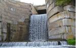
Agur waterfalls. Sochi city, Krasnodar region

A cascade of waterfalls located on the Agura River in the Khostinsky district of Sochi. Distance from the Black Sea coast - 4 km. Further up the river - the Middle Falls, then the Upper.
The Lower Agur Waterfall is the first and most interesting of all three large waterfalls on the Agura River. It consists of two cascades: the lower one is 18 m high and the upper one is 12 m high. Below it is a wide and deep pool of blue water. From the Devil's Hole canyon to the Lower Waterfall it is approximately 1.5 km. Behind the first waterfall, a series of stairs and climbs go up, leading through 500 m to the Middle Agur waterfall - 23 meters, and then to the Upper - 21-meter waterfall. Near the Upper Waterfall, to the left of the path, there are rocks called Eagle Rocks.
Vasyugan swamps. Tomsk, Novosibirsk and Omsk regions

Some of the largest swamps in the world are located in Western Siberia, in the interfluve of the Ob and Irtysh, on the territory of the Vasyugan Plain, located mostly within the Tomsk region, and in small parts - Novosibirsk and Omsk regions and Khanty-Mansi Autonomous Okrug.
The area of the swamps is 53 thousand square meters. km (for comparison: the area of Switzerland is 41 thousand sq. km), the length from west to east is 573 km, from north to south - 320 km.
The Vasyugan swamps arose about 10 thousand years ago and have been constantly increasing since then - 75% of their current area was swamped less than 500 years ago. Swamps are the main source of fresh water in the region (water reserves are 400 cubic km), there are about 800 thousand small lakes, many rivers originate from swamps, in particular: Ava, Bakchar, Bolshoy Yugan, Vasyugan, Demyanka, etc. d.
The Vasyugan swamps are home to numerous local fauna, including rare ones. Rare species of animals in the swamps include, in particular, reindeer, golden eagles, white-tailed eagle, osprey, gray shrike, and peregrine falcon. There are significant quantities of squirrels, moose, sable, wood grouse, partridges, hazel grouse, black grouse, and in smaller quantities mink, otter, and wolverine. Flora also includes rare and endangered plant species and plant communities. Among wild plants, cranberries, blueberries, and cloudberries are widespread.
Now the animal and vegetable world swamps are under threat due to the development of the territory during the exploration and exploitation of oil and gas fields.
Wikipedia materials were used in preparing the article.
Happy travels!

There are various places in the world that are distinguished by their natural beauty, colors, landscapes and rich vegetation. Others are beautiful in their simplicity and subtlety. In this article you will find something you probably haven't seen before: the strangest places in the world, but at the same time incredible beautiful.
1. "Bloody Pond" in Japan
Our list of the strangest places on Earth opens with a bloody spring (called Jigoku, which means hell) - a landmark of the city of Beppu, one of the nine thermal springs, which are more appropriate to look at than to swim in them.
The reddish color is due to the presence of high levels of iron in the hot waters, which makes this place quite strange.
2. Ice Caves of Eisriesenwelt (Austria)
These are the longest ice caves in the world. Today, only a small area of them is open to the public, but this is amazingly enough to allow visitors to experience the wonderful and mysterious whim of nature.


This strange place is located in the Richat structure, on the African continent. It is visible from space due to its length of almost 50 km. The structure is located about 400 meters above sea level in the Sahara Desert in Mauritania and has curious concentric rings. It is believed that the Eye of the Sahara was created by a meteorite impact.
4. Salt Desert

This is a huge salt desert in Bolivia, also known as. This is the largest salt marsh in the world and here you can see active volcanoes, plains with geysers, tall cacti, etc., which make the environment an endless illusion or landscape of another world.
5. Stone forest of China

Shilin Stone Forest, known as the "first wonder of the world", is located in Yunnan Province. This forest covers an area of over 400 square kilometers and showcases amazing rock formations with breathtaking views. The forest was listed as a World Heritage Site in 2007.
6. Spotted Lake Kliluk

It's huge unusual lake located between Washington State and the Canadian province of British Columbia. It is rich in natural resources, but the most amazing thing about it is the strange formation of circles with white borders and puddles inside, reflecting sunlight in blue and green colors, like mirrors or doors to other worlds.
7. Dry deserts of Antarctica

These are authentic dry valleys in Antarctica with dark gravel scattered across the ground that looks like volcanic areas on Canary Islands, which are equated to Mars. The valley is so cool and dry (the driest place on earth) that everything that dies there is preserved like a mummy. She is like a natural freezer. In addition, here you can find the corpses of seals that died several centuries ago.

Our own little Mars on Earth is in Spain. The resemblance of this strange place to the red planet is so high that NASA conducted various experiments here because of this. This river creates such an unusual environment due to its enormous acidity, and it is the high copper content that gives it its red color. All this is due to the fact that gold and copper were mined on the river.

This island has very interesting vegetation that makes it a unique and almost anomalous ecosystem. It is part of an archipelago consisting of four islands in Indian Ocean, which were separated from Africa about 7 million years ago. Like the Galapagos Islands, they contain more than 700 very rare species of both flora and fauna, and about a third are unique to the area.

The Afar Depression in Ethiopia, better known as the Danakil Depression, is one of the hottest inhabited places on Earth, with temperatures ranging from 35 degrees Celsius when it's cool to around 60 degrees Celsius when it's hot. This is an area in the Horn of Africa where tectonic plates separate, allowing the waters of the Red Sea and the Gulf of Aden to reach the land. This is the reason for such bright colors in the landscape. It is worth noting that this is a very volcanic and radiation zone. Undoubtedly, this is one of the most unusual places on Earth.
11. Soaring Geyser Nevada

This geyser in Nevada is one of the strangest attractions in the United States. It was created in 1916 by accident during oil drilling: water heated by geothermal energy came to the surface, causing this colorful spectacle. The geyser consists of various minerals and thermophilic algae that release jets of water 1.5 m into the air and give it such a variety of colors and plastic appearance. This terrace consists of about 40 pools of water on an area of 30 hectares.

Located in Yellowstone National Park. It is the largest geothermal source in the United States and the third largest in the world. With its appearance, it undoubtedly deserves a place on the list of the strangest places on the planet. The source is formed by thermophilic bacteria, which produce colors ranging from green to red. Colors depend on the ratio of chlorophyll and carotenoids, and on water temperature.
These were the strangest places on earth . I hope that the article was interesting for you. Thank you for your attention!
P.S. To reinforce the topic, I suggest watching a video selection of the most beautiful and unusual places on our planet:
A selection for lovers of natural and historical mysteries, as well as for those who simply appreciate beautiful, unusual places. Welcome to 65 corners of the planet that make you think about the irrationality of the world, feel like an explorer and get a dose of adrenaline.
Easter Island, Chile
Easter Island, Chile
This small piece of land in Pacific Ocean(area - 163.6 km², population - about 6,000 people) is known throughout the world thanks to the mysterious stone idols - moai. Almost nine hundred statues stand around the perimeter of the island, like sentinels. Who made them? How were multi-ton blocks moved? What function did the statues serve? Europeans have been puzzling over these questions for decades. And although it is believed that Thor Heyerdahl solved the riddle, local residents still believe that the moai contains the sacred power of the ancestors of the Hotu Matu’a clan.
Aokigahara, Japan
Aokigahara, Japan
This is a dense forest at the foot of Mount Fuji on the island of Honshu. The place is ominous: rocky soil, tree roots entwined with rocky debris, there is a “deafening” silence, compasses do not work. And although scientists (seemingly) have found explanations for all these phenomena, the Japanese believe that ghosts live in the forest - the souls of frail old people who were left there to die in times of famine. Therefore, during the day Aokigahara is a popular vacation spot, and at night it is a “haven” for suicides. Books and songs have been written about this place, films have been made, including documentaries.
Racetrack Playa, USA
Racetrack Playa, USA
In California's Death Valley National Park there is a dry lake that would be ordinary if not for a phenomenon that scientists have been puzzling over for years. 30-kilogram stones move along its clay bottom. Slowly, but without the help of living beings. The blocks leave behind long, shallow furrows. Moreover, the trajectory of their movement is absolutely arbitrary. What pushes stones? Different versions were voiced: the specifics of the magnetic field, wind, seismic activity. None of the guesses has received sufficient scientific substantiation.
Roraima Plateau, Brazil, Venezuela, Guyana
Roraima is a mountain on the border three countries. But its top is not a sharp peak, but a luxurious, cloud-shrouded plateau with an area of 34 km², with unique plants and picturesque waterfalls. This is exactly how Arthur Conan Doyle imagined The Lost World. According to Indian beliefs, Roraima is a petrified tree trunk that gave birth to all the vegetables and fruits on the planet. The Indians also believed that gods lived there, so no one climbed to the top before the arrival of Europeans. Modern travelers say that on Roraima people are simply filled with sacred delight.
Valley of the Jars, Laos
Valley of the Jars, Laos
At the foot of the Annam ridge, giant pots are “scattered”: up to three meters in height and weighing up to six tons. Archaeologists suggest that the jars are about two thousand years old, but they cannot understand how the ancestors of modern Laotians used them. Laotian legends say that these are utensils of giants who lived in the valley. They also say that King Khung Trung ordered the jugs to be made in order to prepare a lot of rice wine and celebrate the victory over the enemies. Historians have their own versions: rainwater could be collected in pots or food could be stored in them. Or maybe they were funeral urns?
Bermuda Triangle
Bermuda Triangle
IN Atlantic Ocean, in the "triangle" between Florida, Bermuda and Puerto Rico, there is an anomalous zone where over the last hundred years more than a hundred sea and aircraft. The most famous case occurred in 1945. Five Avenger bombers took off from a US Navy base and disappeared. The planes that went in search of them also disappeared without a trace. Skeptics say that shoals, cyclones and storms are to blame. But many tend to believe in more mystical versions: for example, in abduction by aliens or inhabitants of Atlantis.
Shilin, China
Shilin, China
In Yunnan province, the “Stone Forest” spreads over an area of 350 km². Ancient rocks, caves, waterfalls and lakes create the atmosphere fairy world. According to legend, one young man decided to save the people from drought and build a dam. The wizard gave him a whip and a rod to cut and move blocks of stone. But the instruments had magical powers only until dawn. The young man did not finish the work, and the huge monoliths remained scattered throughout the valley. Scientists believe that 200 million years ago in place “ Stone forest"There was a sea. It dried up, but the rocks that amaze with their grandeur and beauty remained.
Glastonbury Tower, UK
In the English county of Somerset there is a 145-meter hill topped by the tower of the medieval church of St. Mikhail. According to legend, there was an entrance to Avalon - the other world where holy people, fairy-tale creatures and magicians were born, where special laws of time and space operate. King Arthur and his wife Guinevere were buried on this hill - in 1191, the monks of Glastonbury Abbey allegedly found sarcophagi with their remains. This is not the only legend about St. Michael's Hill and King Arthur. Perhaps these are just myths, but visitors to the attraction claim that the hill has powerful energy.
Whale Alley, Russia
Whale Alley, Russia
On the Chukchi island of Itygran there is an ancient Eskimo sanctuary. Huge whale bones and skulls are buried in the frozen shore. The alley was opened in 1977, but its mysteries have not yet been solved. There is an assumption that in the 14th century this place was used by whalers for ritual meetings. Judging by the many “meat pits,” the gatherings were accompanied by feasts, and the holes in the tops of the whale “pillars” indicate that the whalers may also have played games, hanging prizes on bones. But in folklore there is no information about the purpose of the alley. But there is a legend about the battle of “flying shamans” that took place there.
10
Fly Geyser, USA
Fly Geyser, USA
It’s hard to believe, but this “fountain,” as if straight from the pages of a science fiction writer’s book, is not on Jupiter, not on Mars, but on Earth, in the state of Nevada. The “flying” geyser spews jets of hot water to a height of up to 15 meters, forming a “mini-volcano” of mineral deposits around itself. Scientists claim that this is what the surface of our planet looked like millions of years ago. The geyser is located on the territory of a private ranch, and to admire it, you need permission from the owner. But this does not stop tourists. People believe that if you wash your face with geyser water, life will become bright and happy.
11
Richat, Mauritania
Richat, Mauritania
In the western Sahara there is the “Eye of the Earth”. These huge circles, drawn by an unknown force, really resemble an eye. The Richat structure is the oldest geological formation, the age of one of the rings is about 600 million years. The “Eye” is clearly visible from space; in orbit it is used as a landmark. There are different versions about the nature of this formation. For example, that this is a crater from a meteorite fall or a landing site for aliens. But the most scientific hypotheses suggest that this is the crater of an extinct volcano or the result of erosion on an uplifted section of the earth’s crust.
12
Nazca Lines, Peru
Nazca Lines, Peru
The Nazca Plateau, like a canvas, is covered with giant patterns. A hummingbird, a monkey, a spider, flowers, a lizard, geometric shapes - in total there are about 30 neat designs made in the same style in the valley. Geoglyphs on the Nazca plateau were discovered almost a century ago, but scientists are still arguing about who, how and when created them. Some believe that this is an ancient irrigation system, others that these are the “holy paths of the Incas,” while others claim that this is the oldest astronomy textbook on Earth. There is also a completely mystical version that the lines are a message from aliens. There are many theories, but none have been scientifically confirmed.
13
Podgoretsky Castle, Ukraine
Podgoretsky Castle, Ukraine
The 17th-century palace in the village of Podgortsy, Lviv region, would be an ordinary historical landmark (a perfectly preserved, striking example of Renaissance architecture, the place where D’Artagnan and the Three Musketeers was filmed) if it were not for the anomalies noticed there. According to legend, one of the owners of the castle, Vaclav Rzhevuski, was terribly jealous of his beautiful wife Maria. So much so that he walled her up within the walls of the palace. The caretakers of Podgoretsky Castle claim that they have seen the ghost of the “White Lady” more than once and constantly hear the clicking of heels on the marble floor.
14
Devils Tower, USA
Devils Tower, USA
Devil's Tower, or Devil's Tower, is a columnar mountain in the state of Wyoming. It resembles a tower assembled from individual columns. It's hard to believe that this is a creation of nature and not human hands. Indigenous people treated the tower with awe, because strange light phenomena were observed many times at the top. There is a legend that the devil sits on the top and beats a drum, causing thunder. Because of its bad reputation, climbers avoid the mountain. But she appears in Steven Spielberg’s film “Close Encounters of the Third Kind” - this is where the meeting with aliens takes place.
15
Gaiola Islands, Italy
Gaiola Islands, Italy
In the Gulf of Naples, off the coast of Campania, there are two small islands of wondrous beauty. A bridge connects them together. One of them is uninhabited, the other has a villa built on it. But no one lives in it - the place is considered cursed. All its owners, as well as some members of their families, died under strange circumstances, went bankrupt, and ended up in prisons and psychiatric hospitals. Due to their bad reputation, the islands have no owner and the villa is abandoned. Only occasionally do brave tourists, photographers and journalists visit Gaiola.
16
Bran Castle, Romania
Bran Castle, Romania
In the picturesque town of Bran stands a majestic 14th-century castle. According to legend, Count Vlad III Tepes-Dracula often spent the night here. This man became the prototype of the most famous vampire in pop culture. The count was given the nickname “Dracula” for his incredible cruelty: he killed innocents for fun, took blood baths, could impale a person and eat in the presence of a corpse. The people hated and feared him. Bran Castle is currently a working museum. It is believed that although Vlad III did not live there permanently, the place is imbued with his negative aura.
17
Catatumbo River, Venezuela
Catatumbo River, Venezuela
In the place where the Catatumbo River flows into Lake Maracaibo, a unique atmospheric phenomenon is observed: almost every night the sky is illuminated by lightning without thunder. There are over a million discharges per year. Lightning can be seen hundreds of kilometers away. Scientists have discovered the cause of the phenomenon, but its extraordinary beauty still gives rise to superstitions and legends. In 1595, Catatumbo lightning saved the city of Maracaibo. Pirate Francis Drake decided to capture the city, but because of the lightning, local residents saw his ships approach from afar, managed to prepare and fought back.
18
Body, USA
Body, USA
In California, on the border with Nevada, there is a ghost town named after gold miner William Bodie. In 1880, the city had a population of 10,000. They accounted for 65 saloons and 7 breweries, they even had their own “red light district” - crime, drunkenness and debauchery flourished in the city. When the gold rush died down, people left. Now it is a historical park. But tourists do not come to Bodi because of their interest in history: the city is considered a haven of ghosts. Anyone who takes even a stone from there will be haunted by misfortune. Park rangers constantly receive packages with the return of “souvenirs”.
19
Troll Tongue, Norway
Troll Tongue, Norway
Trolltunga, or Troll's Tongue, is an unusual rock outcrop at an altitude of 350 meters on Mount Skjeggedal. Why language? And why a troll? As an old Norwegian legend says, in those parts there lived a troll who constantly tested fate: he dived into deep pools and jumped over abysses. One day he decided to check whether it was true that the rays of the sun were deadly to trolls. At dawn, he stuck his tongue out of his cave and... was petrified forever. The rock attracts modern adventurers like a magnet: sit on the edge, do a somersault, take a photo. There is no troll, but his work lives on!
20
Brocken, Germany
Brocken, Germany
This is the most high point Harz Mountains (1141 m), where, according to legend, witches held a Sabbath on Walpurgis Night. At the top you can observe a natural phenomenon of rare beauty and mystery - the Brocken ghost. If you stand with your back to the setting sun, a large shadow with a rainbow halo around your head will appear on the surface of the clouds or in the fog. Sometimes you even get the feeling that the “ghost” is moving. The phenomenon was first described by Johann Silberschlag in 1780 and since then has been mentioned more than once in the literature about the Harz Mountains.
21
Golosov Ravine was once a deserted, gloomy outskirts of Moscow. Now this is a beautiful place, shrouded in legends, in the Moscow Kolomenskoye Museum-Reserve. One of the legends tells of a strange green fog. Allegedly, there were cases when people wandered in an emerald haze for what seemed to them to be several minutes, but in reality decades passed. Also in the ravine there are stones that in ancient times had sacred meaning: the Goose Stone patronized warriors, giving them strength and luck in battle, and the Maiden Stone brought happiness to girls.
22
Stonehenge, UK
Stonehenge, UK
130 km from London, in Wiltshire, there is a bizarre structure of huge stone blocks. It is one of the most popular archaeological sites in the world. Researchers have found that the construction of the complex lasted almost two thousand years and took place in several stages. However, it is still unclear who built it and why. According to popular legend, huge blue stones have magical powers, and the structure was erected by a wizard named Merlin. There are also versions that Stonehenge is a Stone Age observatory, a Druid sanctuary or an ancient tomb.
23
Goseck Circle, Germany
Goseck Circle, Germany
The Goseck Circle refers to concentric ditches with a diameter of 75 meters and log circles with gates. Through them, on the days of the summer and winter solstice, the sun penetrates into the circle. This has given rise to the theory that this Neolithic structure is the world's oldest observatory. It was supposedly built in 4900 BC. e. It seems that the creators of the ancient “celestial calendar” had good knowledge of astronomy. It is noteworthy that similar prehistoric structures exist not only near Goseck, but also in other places in Germany, as well as in Austria and Croatia.
24
Machu Picchu, Peru
Machu Picchu, Peru
At the top of the mountain range, at an altitude of 2,450 m, among the clouds above the valley of the Urubamba River, the ancient “lost city of the Incas” rises majestically. Machu Picchu was built in the 15th century, but in 1532 the palaces, altars and houses were abandoned. Where have the residents gone? According to historians, the elite of the Inca Empire lived in Machu Picchu, and with the fall of the empire, the inhabitants simply left in search of better life. According to popular beliefs, most of the population was sacrificed to the gods to save the empire, and the rest scattered throughout the valley. But there is no clear answer.
25
Thor's Well, USA
Thor's Well, USA
A natural funnel with a diameter of 5 meters in the strait of Cape Perpetua was named in honor of the god Thor. But more often it is called the “gate to the underworld.” The spectacle is truly hellishly beautiful: during high tide, water quickly fills the well, and then sharply “shoots” upward in a six-meter fountain, forming a whirlwind of spray. It’s as if there’s a monster living at the bottom that gets angry at the streams of water pouring on it and pushes them back. But it has not yet been possible to find out what is actually inside the funnel - diving there is too dangerous.
26
Moeraki Boulders, New Zealand
Huge stone balls with a diameter of up to two meters are “scattered” along the Koekohe beach, not far from the village of Moeraki. The surface of some of them is absolutely smooth, while others resemble a turtle shell. Some boulders are intact, while others are broken into pieces. Where they came from is a mystery of nature. According to the Maori folk version, these are potatoes that woke up from a mythical canoe. There are also opinions that these are fossilized dinosaur eggs and the remains of alien aircraft. Scientists believe that these are geological formations that formed on the ocean floor millions of years ago.
27
Champ Island, Russia
Champ Island, Russia
Another place with mysterious stone balls is Champ Island, located in the central part of Franz Josef Land (Arkhangelsk region). The entire coast is literally strewn with spherical stones ranging in size from a few centimeters to three meters. Where did they come from deserted island? It is believed that due to the melting of glaciers, stones fell into natural pools and were ground down by water. But why only on this island? Among the supernatural theories are the intervention of aliens and the fact that the stones are artifacts of some lost civilization.
28
Golden Stone, Myanmar
Golden Stone, Myanmar
On the edge of the ledge of the Chaittiyo rock lies a granite boulder 5.5 meters high and about 25 meters in circumference. The boulder has been balancing on the edge of the abyss for several centuries and, contrary to the laws of physics, does not fall. According to legend, Buddha gave a lock of his hair to a hermit monk. To preserve the relic, he placed it under a huge stone erected on the rock by Burmese spirits. The stone is covered with gold leaf and is one of the main Buddhist shrines. It has not yet been possible to find a scientific basis for the phenomenon of the Chaittiyo Pagoda. And is it necessary?
29
Beelitz-Heilstetten, Germany
Beelitz-Heilstetten, Germany
40 km from Berlin there is a sanatorium that was once considered the best in Germany. At first it was a hospital for tuberculosis patients, and then a military hospital. In 1916, the young soldier Adolf Hitler “licked his wounds” there. After World War II, the hospital was at the disposal of the Soviet authorities. Now there are many horror stories associated with the sanatorium in the city of Belits. Allegedly, strange sounds are heard there, and letters from soldiers are still found in the walls of the building. Speculation and nothing more? Probably. But visitors say: the longer you stay there, the more tired and depressed you feel.
30
Mystery Spot, USA
Mystery Spot, USA
"Mystery Spot" translates from English as " Mysterious place" In the mid-twentieth century, businessman George Prater decided to build a house. He chose a place on the hillside, bought land, but was never able to erect a building. The house looked crooked, although the drawings were correct and the builders were sober. It turned out that the laws of physics were violated on the hill: the balls are rolling up an inclined plane, the broom is standing without support, water is flowing upward, people are standing in an inclined position. Scientists say that these are nothing more than optical illusions, but many tend to see a mystical trace in what is happening.
31
Pyramid of Cheops, Egypt
Pyramid of Cheops, Egypt
The largest and most mysterious of the greats Egyptian pyramids located on the Giza plateau. Its height is 138.8 meters (due to the current lack of cladding), the length of the base is 230 meters. Built in the 26th century BC. e. The construction of the pyramid lasted more than 20 years, colossal resources were involved: 2.5 million multi-ton limestone blocks, tens of thousands of slaves. It would seem that the Cheops pyramid has already been studied far and wide, but disputes among scientists do not subside. How did the construction go? How was this gigantic structure used? There are still more questions than answers.
32
Newgrange, Ireland
Newgrange, Ireland
40 km north of Dublin there is an ancient stone structure. It is 700 years older than the Egyptian pyramids. According to legend, Newgrange is the home of the Celtic god of wisdom and the sun, Dagda. According to archaeologists, this place served as a tomb. There is also a version that this is one of the first observatories: during the winter solstice morning rays the sun penetrates the hole above the entrance and illuminates the room from the inside. But researchers still have more questions than answers: where did the inscriptions on the stones come from and what do they mean, how did the builders achieve such accuracy, what tools did they use?
33
Heizhu, China
Heizhu, China
In the south of China there is one of the most powerful anomalous zones world - Heizhu Valley, which translated means “Hollow of Black Bamboo”. Here, under mysterious circumstances, accidents occur and people disappear in thick fog. Find objective reason no one can do what is happening. Some believe that plants that release toxic substances grow and rot in the forest. Others believe that the cause of the strange events is strong geomagnetic radiation. Mystics say that in the valley there is a portal to a parallel world.
34
Horsetail Falls, USA
Horsetail Falls, USA
In Yosemite National Park, on the eastern slope of Mount El Capitan, there is a 650-meter waterfall. Most of the year it is unremarkable, but in February the falling streams of water turn into “lava flows”. This amazing natural phenomenon is due to the fact that at sunset the sun's rays are reflected in the waterfall, creating a visual illusion that hot metal is flowing from the rock. According to legend, at the top of the mountain was the house of a blacksmith who made the best horseshoes for horses in the area. But due to heavy rain, the forge was washed off the cliff. Since then, the waterfall once a year “reminds” of this tragic event.
35
Chillingham Castle, UK
In the north of England, in the county of Northumberland, there is a majestic 12th-century castle with a watchtower. At one time it was of great strategic importance, but in the 17th century it became the residence of the aristocracy. Dramas and intrigues unfolded within its walls, claiming many lives. This may be why Chillingham is Britain's most popular haunted castle these days. There are at least three of them: Shining Boy (appears in blue clothes), Tormentor Sage (seen in the torture room) and Lady Mary Berkeley (emerges from her portrait in the Gray Room).
36
Mercado de Sonora, Mexico
Mercado de Sonora, Mexico
One of the most unusual markets in the world is a dream for magicians and mediums of all stripes. The place, if not mystical, is certainly atmospheric, imbued with many legends. Most tourists visit the witch market simply out of curiosity. Where else can you see bizarre ritual objects, masks, dried snakes, spider legs and rare herbs? Local sorcerers - brujos - can tell fortunes, cleanse the aura and “cure” ailments. Mexicans also often come to the market - they take sorcerers quite seriously.
37
Restaurant T'Spookhuys, Belgium
Restaurant T'Spookhuys, Belgium
“Horror Restaurant”, “House of a Thousand Ghosts” - all this is about the T’Spookhuys establishment in the city of Turnhout. The restaurant was conceived as an attraction for lovers of mysticism: a gloomy interior, fog swirling on the floor, moving pictures, creaking doors, skulls instead of plates, an extraordinary menu and waiters in the role of vampires. At first, the owners' dark humor brought success - there was no end to customers. But a few years later, the restaurant acquired notoriety; they began to say that ghosts actually lived there. Now the establishment is abandoned, but the atmosphere and ominous aura have been preserved.
38
Loch Ness, UK
Loch Ness is a deep lake in the highlands of Scotland where, according to legend, a monster lives. Supposedly this is a creature reminiscent of a prehistoric lizard. One eyewitness described it as follows: 40 feet in length, 4 fins, the body smoothly merges into an elongated neck with small tubercles. There are quite a lot of people who claim to have seen the Loch Ness monster. More than three thousand cases have been recorded. There is even photo and video evidence. But there are also plenty of skeptics. The debate about whether there is a monster in the lake has lasted for decades and flares up with renewed vigor from time to time.
39
Lake Kara-Kul, Russia
Lake Kara-Kul, Russia
The Russian counterpart of the Loch Ness monster, according to legend, lives in Lake Kara-Kul in the Baltasinsky district of the Republic of Tatarstan. This is an elongated reservoir with an average depth of 8 meters and an area of 1.6 hectares. Translated from Tatar “kara-kul” means “black lake”. It is believed that the reservoir was previously surrounded by dense forest, which is why the water appeared black. Local residents have a legend about the bull-like water snake Su Ugez. If she appears to people, expect trouble - fire or famine. There is no documentary evidence of the presence of the monster in the lake. But superstitious people prefer to avoid it.
40
Lake Hillier, Australia
Lake Hillier, Australia
The lake is surrounded by eucalyptus forest, and is separated from the ocean by a narrow strip of land. But the main feature of the lake is that it is pink. The reason for such an unusual color of water has not been solved. It was assumed that the problem was specific algae, but this was not confirmed. But there is a beautiful legend that a sailor who was crippled but survived a shipwreck ended up on desert island. He suffered from pain and hunger and asked heaven for deliverance, until finally a man came out of the forest with jugs of milk and blood. He poured them into the lake, and it acquired pink color. The sailor plunged into the scarlet water and got rid of pain and hunger. Forever.
41
Hvitserkur, Iceland
Hvitserkur, Iceland
This is a 15-meter cliff on the eastern shore of the Vatnsnes peninsula. Its shape resembles a water-drinking dragon. But, according to popular belief, this is a troll who went out to the sun and turned to stone. Scientists believe that Hvitserkur is the remains of an ancient volcano, eroded by salt waters and destroyed by cold winds. To prevent the sea from completely destroying the figure, its base was reinforced with concrete. People from all over the world come to admire this rock. And sometimes what is observed there northern lights gives it additional mystery.
42
Manpupuner, Russia
Manpupuner, Russia
Other names are Weathering Pillars and Mansi Logos. These are mountain outcrops with a height of 30 to 42 meters on the territory of the Pechora-Ilychsky Nature Reserve. It is believed that 200 million years ago there were high mountains in this place, but due to snow, frost and winds, only small pillars remained of them. Many legends are associated with them. According to one of them, the leader of the giant tribe wanted to marry the daughter of the leader of the Mansi tribe. Having received a refusal, the giant attacked the village. It’s good that the beauty’s brother arrived in time: he saved the village by turning the giants into stones with the help of a magic shield.
43
San Zhi, Taiwan
San Zhi, Taiwan
Sanzhi was supposed to be the city of the future. The luxury residential complex consists of futuristic houses shaped like “flying saucers.” An elegant staircase leads to each of the “plates”, and, according to the architects’ idea, you can go down from the second floor directly into the ocean or pool along water slide. Huge amounts of money were allocated for construction. But the company that built San Zhi went bankrupt, and accidents at the construction site gave rise to unkind rumors. The complex was completed, but advertising could no longer change the glory of the “cursed place.” The city is abandoned. The authorities wanted to demolish it, but local residents were against it. They believe that San Zhi is a refuge for lost souls.
44
Singing Dune, Kazakhstan
Singing Dune, Kazakhstan
Not far from Almaty there is a three-kilometer dune with a height of 150 meters. It offers a beautiful view of the Ili River and purple mountains. In dry weather, the dune produces melodic sounds, like an organ. According to one legend, the shaitan, who was wandering around the world and plotting intrigues for people, turned into a dune. According to another version, Genghis Khan and his comrades are buried in the sands. The dune “sings” when the soul of the khan, “exhausted from mental anguish, tells his descendants about his exploits.” It is noteworthy that the dune does not wander across the plain, but stands in place for millennia, despite the unsteadiness of the sand and strong winds.
45
Zone of Silence, Mexico
Zone of Silence, Mexico
An anomalous desert on the border of the states of Durango, Chihuahua and Coahuila, where reception and registration of radio and sound signals is impossible. There the receivers stop working, the compass doesn't work and the clock stops. Scientists have tried several times to establish the cause of the anomalies, but their conclusions boil down to something like this: something is suppressing radio waves. The area, also nicknamed the “Tethys Sea” after the ancient ocean, has been associated with many mysterious incidents: from plane disappearances and missile crashes to evidence of strange travelers leaving scorched grass behind them and UFO landings.
46
Winchester House, USA
Winchester House, USA
525 Winchester Boulevard in San Jose has a bad reputation. There are 160 rooms and 6 kitchens on three floors. At the same time, many doors lead to a dead end, steps go to the ceiling, and windows go to the floor. Not a house, but a labyrinth! This architectural “miracle” was created by Sarah Winchester. Her father-in-law made weapons, for which, according to the woman, a curse was placed on their family. On the advice of a medium, she built a house for the souls of people whose lives were taken by the inventions of old man Winchester. According to rumors, house number 525 is actually haunted. But even without them, the gloomy layout gives visitors chills.
Valley of the Mills, Italy
In the heart of Sorrento, at the bottom of the gorge that divides the city into two parts, there are ruins medieval city, the highlight of which was water mills. Hence the name of the valley - Valle dei Mulini. The walls of the ancient mill have almost collapsed, the wheel is overgrown with moss - in the middle modern city it's like a fragment of another world. Perhaps that is why the Valley of Mills is one of the favorite attractions of fans of mysticism. They believe that the mill has otherworldly inhabitants. Allegedly, laughter is sometimes heard from the gorge, and a strange light is visible from the windows of the building.
48
Dancing forest, Russia
Dancing forest, Russia
37 km from the Curonian Spit (Kaliningrad region) there is an unusual coniferous forest. Tree trunks are intricately curved and twisted into spirals. The forest was planted in 1961, and it is still unclear why the pines “started dancing.” According to one version, the trunks of still young trees are damaged by the caterpillars of the hibernating shoot. According to another, the reason lies in the geomagnetic effect of a tectonic fracture. Ufologists see the intervention of an alien intelligence in everything. In 2006, new trees were planted in the forest to see if they would bend. While the seedlings are growing straight.
49
Pluckley, UK
Pluckley, UK
This is a place in the English county of Kent where, according to legend, at least a dozen ghosts live. On the road from Pluckley to Maltman's Hill, a carriage drawn by four horses appears from time to time, the spirit of a colonel wanders through the pasture, and on one of the streets you can stumble upon the phantom of a hanged man. Each of the 12 ghosts has its own story. Local residents say that they have become accustomed to their “neighbors” from the other world and are no longer afraid of them. But many believe that the ghosts are a publicity stunt to attract tourists. True, it has not yet been possible to prove this, as well as the presence of ghosts.
50
Catacombs of Jihlava, Czech Republic
Catacombs of Jihlava, Czech Republic
Jihlava is a city in the southeast of the Czech Republic. One of its main attractions is the 25-kilometer catacombs. Once these were silver mines, then they began to be used for economic needs. In 1996, archaeologists worked in the catacombs and recorded that the sound of an organ was heard in the place indicated by the legends, and in one of the passages the researchers discovered a “luminous staircase” emitting a reddish light. Archaeologists were examined - mass hallucinations were excluded. The reasons for the mysterious phenomena are unknown.
51
Temehea-Tohua, French Polynesia
On the island of Nuku Hiva, part of the Marquesas archipelago, in the town of Temehea-Tohua, statues of strange creatures were found. Disproportional bodies, elongated heads with large mouths and eyes. Archaeologists date the creation of the mysterious idols to approximately the 10th–11th centuries. Why did the Aboriginal people make them? By official version, these are monuments to priests in ritual masks. But it is strange that the masks themselves were not found on the island. Hence the assumption that Nuku Hiva was once visited by aliens, and local residents imprinted their appearance in stone.
52
Great Blue Hole, Belize
Great Blue Hole, Belize
This is a huge funnel with a diameter of 305 meters and a depth of 120 meters. Located in the center of Lighthouse Reef. In 1972, Jacques-Yves Cousteau established that it was originally a system of limestone caves that originated during the Ice Age. When the sea level rose, the roof of the cave collapsed and a karst sinkhole was formed. But there is an opinion that flooding could not have provoked destruction - the size is too large, the shape is too regular. There had to be an external influence, for example, a meteorite fall.
53
Lake Paasselka, Finland
Lake Paasselka, Finland
In autumn, on Lake Paasselka you can see lights wandering across the water surface. Some of them are spherical, others resemble flames. According to Finnish beliefs, they point to places where treasures are hidden. But they lure greedy people to depths from which it is difficult for even experienced swimmers to escape. Will-o'-the-wisps are also found in other parts of the planet, but they were captured on Paasselka. They say different things about the nature of the strange lights: either discharges of electricity in the atmosphere, or flammable methane coming out of the ground, or maybe traces of a UFO moving?
54
Lake Ertso, South Ossetia
Lake Ertso, South Ossetia
This is a picturesque reservoir with a length of 940 meters in the Dzau region South Ossetia. Local residents often call it a “ghost lake”, since every 5-6 years all the water disappears from the lake and then returns back. According to legend, in the old days a greedy rich man lived on its shore. Angry peasants drowned him, and since then his greedy spirit periodically drinks all the water in the lake, and then falls into oblivion again. Geologists suggest that the water goes into karst caves under the bottom of the reservoir. Ufologists have their own version that there is an alien base under the lake.
55
Shichen, China
Shichen, China
An ancient city, flooded in 1959 as a result of the construction of a hydroelectric power station. Shichen, or "Lion City", was founded in 670. Five city gates with towers, six stone streets - everything was under water. The size of the Lion City is about 62 football fields. Surprisingly, even after half a century, the city is perfectly preserved, including wooden beams and steps, as if this “Chinese Atlantis” is inhabited and someone carefully maintains order there. The mysterious underwater kingdom is very popular among divers.
56
Hashima Island, Japan
Hashima Island, Japan
Located in the Pacific Ocean, 15 km from the city of Nagasaki. The Japanese call it “gunkanjima”, that is, “cruiser” - the island looks like a ship. In 1810, a coal deposit was found there. In the 1930s, Hashima was a significant industrial center. In the second half of the twentieth century, more than 5 thousand people lived there. But coal reserves were melting, and along with them the population was declining. Currently, the abandoned island is partially open to the public. Tourists enjoy wandering among the gloomy buildings, listening to the stories of the guides. Hashima became one of the illustrations of the deserted world in the series “Life after People.”
57
Amur Pillars, Russia
Amur Pillars, Russia
A natural monument 134 km from Komsomolsk-on-Amur, glorified in legends. Granite pillars from 12 to 70 meters high stand on the slopes of the hill and have their own names: Shaman-stone, Walls, Bowl, Church, Crown, Heart, Turtle and others. Local residents talk about the strange aura of the stones, and shamans still perform rituals there. Scientists have made various assumptions about the origin of the Amur Pillars. According to one version, they are about 170 million years old and are the result of the activity of an underground volcano.
58
"Sacred Forest", Italy
"Sacred Forest", Italy
The town of Bomarzo is home to the ominous but beautiful “Sacred Forest,” or “Garden of Monsters.” The park has about thirty mythologically inspired sculptures and fantastic buildings covered with moss: an elephant devouring a man, a three-headed monster, a dragon dog, the gates of the underworld and others. All these are the fruits of the imagination of Pier Francesco Orsini, who decided to perpetuate the memory of his tragically deceased wife. The Orsini heirs did not take care of the park, and it acquired an ominous appearance. There were rumors that evil spirits were roaming there. But despite this, the park became a source of inspiration for Salvador Dali, Manuel Mujica Lainez and other creators.
59
Stanley Hotel, USA
Stanley Hotel, USA
Located in Colorado, near Rocky Mountain National Park. Built in the early 20th century, the hotel consists of 140 apartments and is believed to be haunted by ghosts, such as the ghost of a musician playing the piano. There have never been murders or other terrible events at the hotel, but the place is literally imbued with mysticism. It inspired Stephen King to write the book “The Shining,” which was later adapted into a TV series—the hotel itself served as the “scenery.” And Stanley Kubrick's feature film of the same name became one of the best horror films in cinema history.
60
Nesvizh Castle, Belarus
Nesvizh Castle, Belarus
This palace and castle complex is included in the UNESCO World Heritage List. The legend of the Black Lady is associated with it, the prototype of which is the cousin of the first owner of the castle, Barbara. Her lover’s mother did not bless their marriage, and when they finally got married secretly, she poisoned her daughter-in-law. The grief-stricken husband asked the alchemist to summon the spirit of his wife in order to look at her again. During a seance, the widower, in a fit of emotion, touched Barbara, which was absolutely forbidden to do. Since then, her ghost allegedly lives within the walls of Nesvizh Castle.
61
Teotihuacan, Mexico
Teotihuacan, Mexico
"Teotihuacan" means "city of the gods." This mysterious place is located 50 km from Mexico City. Now the city is deserted, but once it was inhabited by more than two hundred thousand people. The layout is striking: the regular lines of the streets form blocks and at the same time are strictly perpendicular to the main avenue. In the center of the city is a huge square with massive pyramids on platforms. Teotihuacan was built according to a carefully thought-out plan and flourished. But in the 7th century it was abandoned. Why is unclear. Either because of a foreign invasion, or because of a popular uprising.
62
Skeleton Coast, Namibia
Skeleton Coast, Namibia
In the middle of the sand dunes of the national park, dilapidated ships seem like phantoms. But these are real ships that were once caught in a storm and moored to the shore to wait out the storm. Due to the shifting sands, ships found themselves cut off from the water, often at quite a distance from the ocean. One of the most famous “prisoners” of the mysterious coast is the steamship “Eduard Bohlen”, which found its final refuge about two centuries ago. The southern part of the Skeleton Coast is open to visitors and is of great interest to lovers of mysticism.
63
Hicks Point, Australia
Hicks Point, Australia
In 1947, the keeper of Australia's tallest lighthouse went fishing and never returned. And the new caretakers allegedly began to notice strange things: shuffling, heavy tread on spiral staircase, sighs, door handles polished to a shine. Thus was born the legend that a ghost settled in the lighthouse. The Cape Hicks Lighthouse is currently open to visitors. There you can admire the local beauty and spend the night. Every year, thousands of tourists come to Hicks Point in hopes of seeing the ghost of the lighthouse keeper.
64
Chandragupta Column, India
Chandragupta Column, India
A seven-meter iron column, part of the architectural ensemble of Qutub Minar. This is one of the main attractions of Delhi. Its uniqueness lies in the fact that over the centuries it has hardly undergone corrosion. It was suggested that the reason for this was a special metal and a favorable climate. According to another version, the column was preserved because of the oils with which pilgrims wiped it. But none of the hypotheses has been officially confirmed: it is still unclear how in 415 it was possible to obtain the prototype of modern weather-resistant steel.
65
Bulgakov's apartment, Russia
Bulgakov's apartment, Russia
In the 50th apartment of house No. 10 on Bolshaya Sadovaya there is a museum of Mikhail Bulgakov. The writer lived there from 1921 to 1924, and it is believed that this particular place became the prototype of the apartment where the “Satan’s Ball” took place in the novel “The Master and Margarita.” The entire front door is covered with lines from the novel - visitors are immersed in an atmosphere of mysticism without even crossing the threshold. There is an urban legend that on moonless nights the sounds of a piano can be heard from the “bad apartment”, and strange silhouettes flash through its windows. Therefore, the museum is visited not only by fans of the writer, but also by lovers of mysticism, confident that Woland, the cat Behemoth and other characters are not fiction at all.