Detailed map of the Altai region with settlements. Satellite map of the Altai Territory Map of the eastern part of the Altai Territory
How can a motorist find the right way in the Altai Territory?
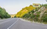
The total length of roads in the region is more than 16 thousand kilometers. It takes a lot of time to drive around all these roads. Why are the routes so long? The point is the number of settlements - there are more than 1.5 thousand in the region. Each of them is provided transport links. Moreover, the villages are located evenly, “covering” almost the entire territory Altai Territory.
On the ones given here interactive maps The main highways of the Altai Territory are indicated. In the future, their number will be replenished, and the introduction of new roadside service facilities will continue. Site visitors take an active part in compiling maps, not only suggesting objects for placement, but also rating them using a rating voting system.
All this is done so that any car traveler, before traveling through Altai, can determine in advance not only the final goal, but also stops along the way to inspect various objects, “coffee breaks,” refueling and car maintenance.
Even a person unprepared in advance can go to Altai. What do you need to do to find the right path? Good advice given on the automobile forum Drom.ru
The most reliable thing would be to talk to truck drivers or bus drivers at a cafe, and even go after someone in pairs (and you won’t run into traffic cops and you’ll be safer, after all, the guys are radio-controlled, you never know if there’s a snowstorm or anything)
So, you can check the driving directions with truck drivers. They can be found near roadside establishments. “Putting up” behind a truck and moving under its “cover” is the right path, but it may seem long for some.
In good weather with excellent visibility, is there any point in “reaching out”? All you need to do is find the right path - turn in the right place at unfamiliar road junctions and intersections.
One of the answers that is “on the surface” is to use a navigator. But it’s no secret that this device does not always work correctly, it can even lead you into the “open field”, and some car friends got into dead-end situations with its help.
Here's another good piece of advice from a motorists forum:
Simple tourist map- this is the correct option.
Yes, it's elementary! Unfold the map - and you're in the know! The only “but”: it will not always be possible to find a map with current data, with road service facilities in certain areas.
Let each traveler decide for himself what to do. To help tourists, detailed maps are compiled on the website “Route 22 Altai”, so that a vacationer can, looking at the interactive diagram on his tablet or other mobile device, travel along the correct trajectory. At the same time, imagine what interesting establishment or tourist attraction awaits him there - around the next turn...
Satellite map of Altai Territory
Map of the Altai Territory from satellite. You can view the satellite map of the Altai Territory in the following modes: map of the Altai Territory with names of objects, satellite map of the Altai Territory, geographic map of the Altai Territory.Altai region- region in Western Siberia. This is one of the most beautiful corners not only in Russia, but also on the entire continent. Several large rivers flow through the territory of the Altai Territory - Katun and Biya, which, merging, form a single river Ob.
The Altai region, surrounded by mountain ranges, is a favorite place for environmental travelers and lovers extreme species sports. Often Altai is called the second most beautiful Switzerland, but unlike the Alps, the Altai region is cleaner and calmer in terms of tourism.
This region is rich in its resort resources, which include clean mountain air, plenty of sun, mineral springs with healing water and much more.
Going to the Altai Territory, each traveler can choose the most suitable a tourist route and type of tourism. One of the most popular and interesting tours offered by numerous travel agencies is climbing Mount Aktru. During this tour, tourists will be able to get acquainted with the nature of the region and plunge into its unique atmosphere.
In addition, a trip to the Altai Territory can be diversified with other activities: horseback riding and camel riding, bicycle tours, skiing and snowboarding, relaxing at camp sites and sanatoriums near mineral springs, as well as rafting on raging rivers. www.russ-maps.ru
Altai Territory is a region located in the southeast of Western Siberia. A map of the Altai Territory shows that the region borders on Kemerovo and Novosibirsk regions, Kazakhstan and the Altai Republic. The area of the region is 167,966 km2.
The Altai Territory is divided into 59 rural districts, 12 cities and 1 closed territorial entity. Largest cities regions - Barnaul (administrative center), Biysk, Rubtsovsk, Novoaltaisk and Zarinsk.
The region contains unique deposits of granite, porphyry, marble and jasper. The economy of the Altai Territory is based on the work of machine-building enterprises, defense industry enterprises and the food industry. Agriculture plays a major role in the region's economy.
Historical reference
The settlement of the region began in the second half of the 17th century. Until the mid-19th century, the region had a well-developed mining industry. After 1861, factories and mining operations began to close. Agriculture began to actively develop.
In 1937, the Altai Territory was formed. During the Great Patriotic War, numerous factories and enterprises were evacuated to the region. In the mid-60s and 70s, large-scale development of virgin lands began.

Must Visit
On detailed map In the Altai Territory you can see the natural attractions of the region: Lake Kulundinskoye, 33 natural reserves, mountains Charming, Sinyukha and Semipeschernaya, lakes Beloe, Mokhovoye and Aya. It is recommended to visit the cities of Barnaul, Biysk and Rubtsovsk.
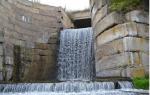
The resort town of Belokurikha, the rock “Four Brothers” near Belokurikha, the Tigiretsky Nature Reserve, the cascade of waterfalls on the Shinok River, the caves “Hyena’s Lair”, “Altaiskaya”, “Geofizicheskaya”, “Terrible” and Tavdinsky caves are a must-see.
Note to tourists
Map of the Altai Territory from satellite. Explore the satellite map of the Altai Territory online in real time. A detailed map of the Altai Territory was created based on high-resolution satellite images. As close as possible, the satellite map of the Altai Territory allows you to study in detail the streets, individual houses and attractions of the Altai Territory. The map of the Altai Territory from a satellite can easily be switched to regular map mode (diagram).
Altai region- region in Western Siberia. This is one of the most beautiful corners not only in Russia, but also on the entire continent. Several large rivers flow through the territory of the Altai Territory - Katun and Biya, which, merging, form a single river Ob.
The Altai region, surrounded by mountain ranges, is a favorite destination for eco-travellers and extreme sports enthusiasts. It is often called the second most beautiful Switzerland, but unlike the Alps, the Altai region is cleaner and calmer in terms of tourism.
This region is rich in its resort resources, which include clean mountain air, plenty of sun, mineral springs with healing water and much more.
Going to Altai region, each traveler can choose the most suitable tourist route and type of tourism. One of the most popular and interesting tours offered by numerous travel agencies is climbing Mount Aktru. During this tour, tourists will be able to get acquainted with the nature of the region and plunge into its unique atmosphere.
In addition, a trip to the Altai Territory can be diversified with other activities: horseback riding and camel riding, bicycle tours, skiing and snowboarding, relaxing at camp sites and sanatoriums near mineral springs, as well as rafting on raging rivers.
Best resorts Altai Territory– this is Belokurikha for those who want to spend a calm, relaxed holiday in radon baths, the city of Yarovoy, famous for its healing mud, and the village of Solonovka, where various sports competitions are held annually.