Ergaki mountains. Open the left ergaki menu. Ergaki, Krasnoyarsk Territory: Address, Address, Ergaki
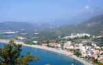
To visit Siberia and not visit Ergaki is an unforgivable oversight. A unique natural park in the south of the Krasnoyarsk Territory attracts tourists with the unique beauty of the local area with its bizarrely shaped rocky spurs, protected trails and clear lakes.

Pearl of Western Sayan
The Ergaki Park environmental protection zone is located within the Western Sayan, a mountain system in the south of Siberia. The total area of the park is 342,873 hectares, the length from west to east is 120 km, from north to south only 75 km, so if you wish, you can visit the main attractions of the park in a few days.
Ergaki is a relief mountain range, where the most significant natural monuments have characteristic features and unique names. Many large and small lakes of glacial origin give these places a unique charm, and some flora and fauna are typical only for these places.
If time and weather permit, every tourist should visit the main attractions of Ergakov:
— Khudozhnikov Pass;
— mountain formation Sleeping Sayan;
— Brothers rocks (Parabola);
— Zvezdny Peak;
— Dragon's Tooth Peak;
— Stone City OK;
— Hanging stone;
— Bird Peak;
— Lake of Mountain Spirits;
— Lake Raduzhnoe;
— Lake Svetloe;
- Marble Lake.

Panorama of the peaks Bird, Zvezdny, Zvezdochka, Elephant rock, etc. Coverage is about 180 degrees. The incredible magnetism of the local beauties makes Ergaki the most visited natural park in the Altai-Sayan ecological region. Each creation of nature on the territory of Ergakov is unique in its own way, shrouded in secrets and beautiful legends.
Sleeping Sayan
The mountain range, the topography of which resembles a person lying on his back, can be seen from afar. The noble profile, flowing long hair and hands folded on the chest represent peace, but not oblivion. According to legend, in ancient times a kind and wise master ruled here, but he was mortal, and his departure was inevitable.
The gods did not separate Ergaki and Sayan and he became the eternal guardian of the mountains. As the legend says, the Sleeping Sayan will definitely wake up if his small country is in danger.

Sleeping Sayan is a symbol of the Siberian mountains and one of the wonders of Ergakov.

hanging stone
Over Rainbow Lake, contrary to the laws of physics, hangs a giant block weighing about 10 tons, which has a purely symbolic fulcrum. Initially, the stone was called “swinging” because anyone could shake the block, but no one was able to push it down. As a result, small fragments filled the space at the base of the stone, and it stopped rocking.
According to one of the legends, when the Hanging Stone falls into the Rainbow Lake, the splashes will reach the Sleeping Sayan and wake him up.

The last rays of the setting sun illuminated the “Hanging Stone” and “Sleeping Sayan”, iconic places in Ergaki.
Brothers (Parabola)
For everyone who visits Ergaki, the photo of Brothers Mountain becomes the highlight of the collection. Nature has its own views on architecture and proof of this are parabolic-shaped rock formations with a perfectly polished parabolic surface. One of the discoverers saw in the outlines of the mountains the figures of people holding hands tightly, one larger, the other smaller.
Since then, the rocks, along with Parabola, began to be called Brothers, enchanted by spirits and left to guard fabulous riches. However, scientists still cannot explain the reasons for the phenomenally smooth surface of the mountains and even doubt their natural origin. In rainy weather, the Parabola has a metallic sheen, evoking thoughts of the work of the hands of representatives of an ancient civilization.

Ergaki, Mount Parabola, Big Brother.


Artists' Pass
Truly iconic place for connoisseurs of nature in its pristine beauty. Long before Ergak was assigned the status natural monument This corner of Siberia attracted creative people like a magnet. The artist and poet Toivo Rännel, the artist and graphic artist Rudolf Ruiga, the Honored Artist of the RSFSR Vladimir Meshkov and many other artists who immortalized the extraordinary beauty of Ergakov in their creations visited here more than once.
From the heights of the Artists Pass, breathtaking views of the valley of the Left Taigish River, the ideal geometry of the pointed cliffs of Parabola, the highest peak Zvezdny, the mysterious Dragon's Tooth and the majestic Peak Bird open up.

Morning at Lake of Artists.

View of the Taigish River valley from the Khudozhnikov Pass.
Peak Zvezdny
The highest point of Ergakov is the pointed peak Zvezdny, 2265 m high. The treacherous and dangerous mountain with almost vertical walls remained unconquered for a long time. Only in July 1969 did climbers from Krasnoyarsk climb to the top of the peak, and then only on the second attempt.
The conquest of the peak coincided with the news of the landing of American astronauts on the Moon and the leader of the group, inspired by this event, decided to call the most difficult Ergakov ridge Zvezdny Peak.

Zvezdny Peak highest point Natural Park Ergaki, height 2265 meters.

Zvezdny Peak Massif.


Rock Bird
One of the central ridges of Ergakov, adjacent to Zvezdny Peak, surprisingly resembles a gigantic bird. A stone giant with wide-open wings menacingly surveys the surroundings, protecting its chicks.

View from the “bird” pass to the lakes of “mountain spirits” and Ergaki park.
Dragon Tooth
Getting acquainted with the magical beauty of Ergakov, you involuntarily begin to believe in fairy tales. One has only to look at the famous Dragon's Tooth and there is no doubt that a giant beast with a sharp fang sticking out of its mouth is hiding in the bowels of the earth.

On the Dragon's Tooth.
One of the sides of the mountain, about 1000 m high, is extremely popular among rock climbers and becomes a real challenge for summiteers.
Lake Svetloe
A natural reservoir of exceptional beauty, a real diamond framed by dense taiga forests, looked down upon by silent and majestic guards - the giant stone Bird and Star Peak.
Lake Svetloe with a crystal clear mirror surface is sometimes called Bolshoy. Its length from north to south is 2 km and 1 km from west to east.


Lake Azure
Lake Lazurnoe is surrounded by coniferous loess and is located between two mountain ranges, which makes it one of the most picturesque lakes in Ergaki.

Lake Taiga Eye
Lake Taiga Eye with crystal clear water is surrounded by the unimaginable silence of mountains rising into the sky.

Stone town
As the ancient legend says, the ancient Sayan people once lived here, hardworking and creative people. But they had to defend their land from the invasion of the hordes of the Tatar Khan and they fell in an unequal battle, leaving behind a fantastic-looking stone city with narrow winding streets.
You don’t need to have a vivid imagination to see on the relief surface of the rocks that form the settlement the faces of ancient inhabitants and warriors, the outlines of their homes and the silhouettes of animals.
However, even the most highly artistic photo of Ergakov is unable to convey the true beauty of these places. Only by arriving in this protected corner of the Russian land can you feel its natural magnetism and magical aura.

Ergaki received the status of a specially protected natural area only on April 4, 2005. The official emblem of the park is an image of a Siberian musk deer against the background of rocky peaks, as a symbol of revival and special attention to such a different and unique nature.
Route thread: Abakan - Usinsky tract - Tushkanchik river - Svetloe lake - Tushkanchik pass (n/k) - Nizhneye Buibinskoe lake - Khudozhnikov-2 pass (1A*) - Nizhnyaya Parabola pass (n/k) - Bird pass (1A) - Svetloe lake - Zvezdny pass (2A) - Piquant pass (1B) - Vidovka pass (n/k) - Lake Svetloe - Jerboa waterfall (radially) - Lake Zolotarnoe - Zeleny pass (1A) - Lake Bezrybnye (radially) - Gemini Western pass (1B) - ascent to the Dragon's Tooth peak (2176 m) - link Zharki pass - Vostochny pass (1A) - Bolshoye Buibinskoye lake - Verkhnyaya Buiba river - Lugovoi stream - Svetloye lake - Tushkanchik river - Usinsky tract - Abakan.
Key points along the route (Google Earth): download
Preparing for the hike to Ergaki
Ergaki are famous for their beauty not only in Siberia, but throughout the country. High mountainous terrain, deep trough valleys, tarn lakes, numerous waterfalls... All this makes a hike to Ergaki a wonderful place for lovers of pristine nature. It is also important that you can get to Lake Svetloye or Lake Raduzhnoe (the starting points of most routes in Ergaki) in just 3-4 hours of trekking from the Abakan-Kyzyl road. Most of the peaks of the main Ergakov ridge exceed 2000 meters, the highest point being Zvezdny Peak (2265 m). Most of the passes have elevations exceeding 1500 m and are located in the alpine belt. About 15 passes are qualified, including 4 passes 2A, 6 passes 1B kt.
In the summer of 1996, German Nikolaevich Babushkin gathered a group on a trip to Lake Baikal. But due to a number of circumstances, the trip to Baikal had to be postponed until next year, and I was handed over to the caring hands of Vladimir Georgievich Fiofilov, who was gathering a group for Borus. However, at one of the evenings of the Zelenogorsk tourist club “Firn”, Rimma Ivanova appeared and offered us another option - a trip to Ergaki, where she herself was going with her children in mid-June. That's what they decided on. The preparations have begun.
Final composition of the group:
- Vladimir "Grandfather" Fiofilov - IV mountaineer, 43 years old, leader
- Nelly Simonova - III mountaineer, 48 years old, supply manager
- Natalya Ryabykh - III mountaineer, 30 years old, doctor
- Dmitry Kovinov (that is, me) - no experience, 15 years, photographer
- Sergey Rubanenko - no experience, 14 years old, repairman
A food ration was prescribed. I was assigned to purchase, pack and carry throughout the entire trip
- three cans of stew
- kilo of dried potatoes
- 2 kg sugar
- 1.5 kg dried smoked sausage
- three packs of jelly
- 1 kg raisins
- 1.5 kg loin
- 1 kg cookies
- crackers from 2 loaves of bread
- 5 cans of canned fish
- 1.5 kg semolina
The result was 12.5 kg. The rest had about the same amount, but of course other products. Thus, our budget for this trip to Ergaki amounted to 850 grams per person per day.
From public equipment I carried: a two-handed saw, a coil of 11 mm rope, and from personal equipment in addition to the usual: a chest harness, a carabiner and tops. Plus, since my mom is a doctor, I was tasked with packing a first aid kit. The following medications were included in it: stomach tablets, painkillers, anti-inflammatory tablets. infectious diseases, dressing material, 200 grams of medical alcohol, antiseptics and an elastic tourniquet.
It must be said that before going to Ergaki I was a real “teapot”. I had no experience of large hikes, and most importantly at that time, practically no hiking equipment! I had to buy a backpack, a sleeping bag and an anti-encephalitis suit, which was outlandish for me.
Road to Ergaki
So, the start of the hike (boarding a bus on the route Zelenogorsk - Zaozernaya) was scheduled for “five thirty on Monday.” On Sunday, as a conscientious tourist, I packed a backpack (it turned out to be 37 kilograms!!!) and tried to walk with it along the road near the house. Then it seemed to me not just heavy, but very heavy. Fortunately, before this hike, I walked six times with a weight of 15-20 kilograms up the mountain near my house (I put bricks in my backpack).
In general, on the scheduled day, I got up at 4:20 in the morning, conscientiously had breakfast and harnessed my dad to take me to the bus. Having arrived at the place, I discovered, or rather did not find, a single soul from our group. In complete bewilderment, after waiting for the bus to leave, I went to “Grandfather”. When the doorbell rang, a sleepy, but already clean-shaven man with a bewildered expression on his face answered the door. In response to his bewilderment, I began to explain to him that our bus had already left, to which I received a very clear answer: “Dima, the train from Zaozerka is at seven o’clock in the evening!!!” Turning around, I went home and went to bed for another two hours. When my mother came home from work, she was very surprised why I was still at home. Then, without incident, we reached Zaozerka, and then to Uyar station.
New surprises began in Uyar: it turned out that previously ordered tickets for seats on the train ended up in different cars. After a short conversation between Natasha and the cashier, everything was settled.
We traveled normally on the train and arrived in Abakan at 11:15 am the next day. We were lucky, and already at 12 o’clock we were sitting on the Abakan-Kyzyl bus. It should be noted that on the bus, most likely, we were the only Russians, the rest were Tuvans. The bus was good - Ikarus, and we hit the road. On the way I slept a little, but after 3 hours the MOUNTAINS began to appear. Then the whole dream vanished. Our bus, as it turned out, was only good in appearance.
In the village of Ermakovskoye, the bus made a long stop at a roadside cafe, where we, like almost all the passengers, had a hearty lunch. Almost immediately after Ermakovsky the road went uphill. Our Ikarus, like a donkey, was forced to stop every hour so as not to overheat. Having probably reached the highest point of the road, the belts on the engine broke and another hour-long stop followed. But despite these troubles, the impression of the mountains visible mainly to the left of the direction of travel was enormous. I looked at some “Sayan head”, at a “bird”, “starry” and could not even imagine that in three or four days I myself would be making my way among these peaks...
Up the Jerboa River
Well, at five o’clock in the evening the Jerboa River, which we had been waiting for so long, finally appeared. Before we could get off the bus, we saw our friend, Rimma Ivanovna, who was already waiting for us. After saying hello, we set off. But they hadn’t walked even a hundred meters before they came to the camp. There were a lot of people there, young and old: both children and adults. Some sat and talked, others joked, others bustled around the camp. After sitting in their camp, we moved up Jerboa. I must say that at first the mood was not very good due to what we were told. Namely: “Two weeks before our arrival, just as Rimma Ivanovna’s group was starting to hike, the rains began, and out of the 15 days they spent in Ergaki, it rained for 12 days.” The path we walked along was muddy and wet. The backpack seemed terribly heavy to me. We walked with stops every 15-20 minutes. And after passing some kind of “ant hill” we met three guys. They turned out to be members of Rimma Ivanovna’s group.
We decided to spend the night at a place with the funny name “ant hill”. This was my first night in a tent, much less in the mountains. The boys told us about the difficulties of the hike, and looked very serious and important, apparently mistaking us for “dummies” who do not understand anything about real hikes. In the evening they cooked dinner and sawed wood. It was very interesting to watch the rather well-coordinated work of everyone in the camp, and I thought that I, too, would soon know exactly what to do without outside help. That day we walked only 4 km, but that seemed enough to me. Clean running time is about 1.5 hours.
Nice sunny morning. We still go up along the left bank of the river. About an hour later, our road is blocked by a stream flowing into Jerboa. It turns out that this stream flows out of Lake Svetloe. Without crossing it, we go further along the coast, gaining altitude quite quickly. Mountains appear on the left. “Bird” and “Star” are clearly visible - the most famous peaks of the Ergaki ridge. We come out onto a huge field, completely covered with roasts and wild garlic. Let's grab some for lunch. We turn left, and after 10 minutes we find ourselves on Lake Svetloe.


Meadows with wild garlic and frying near Lake Svetloe
Base camp on Lake Svetloe
Lake Svetloe is one of the most convenient places for a base camp for a circular route. From here it’s easy to get to Lake Maloe Buibinskoye, get to the valley of the Taigish River through the Lake of Mountain Spirits, or along a good trail in just a couple of hours you’ll be on Lake Zolotarnoye. It is here that we decide to set up our base camp, which will become the starting point of our three rings and one radial exit. There is warm water, a lot of space for tents, there is a lot of forest around and there are not many problems with firewood. In addition, it is very close to the road, and if something happens, you can run to the road in 2 hours if you are light.

We leave immediately after lunch. We take food with us for 3 days, the rest is to be thrown away. Now there are 10 of us: five of us and Rima and four boys. We go around Lake Svetloe on the left, not far from the shore we cross the stream along the logs, which originates here. Then we move along a good path. We pass several small “rotten” lakes and go to the Medvezhiy spring. We cross it on an overturned log; you can’t get through the ford without insurance. On the right bank there is an alpizba. We go inside - no one. Then continue along the path again to the Jerboa River. We cross the ford and take the path straight to the Jerboa Pass (n/k), located to the right of the top of Mount Jerboa itself, an ancient volcano with a destroyed crater.

At the Minusinsk hut (they say it burned down after a couple of years)


Jerboa Pass (n/k, 1700 m) - really n/k (nothing!) - forest, grass, in some places even a horse trail. In a word - a puller. The pass saddle is very wide. During a smoke break we ran closer to the top. There, from the bottom of the crater, along the inner slopes, you can make technically challenging ascents using rock climbing techniques. Then we go down to Lake Maloe Buibinskoye. We arrive at the overnight stay only at 21:30. We set up our tents right on huge boulders, as this is the only dry and almost level place in the area. Moreover, in the event of a rainstorm, there is nothing to be afraid of water going under the tent.
"Hanging Stone" and Khuzhnikov Pass
In the morning we went to the “Hanging Stone” - a huge boulder at the top of the mountain, lying on the ground only a small part, forming a huge canopy. The name is due to the fact that this stone lies on the edge of a large cliff, so that it seems to be hanging. Many tried to push it, but no one succeeded, this pebble was too heavy.

On the ridge near the Hanging Stone
Below is Lake Nizhneye Buibinskoye

"The Hanging Stone" is the calling card of the Ergakovs!
Below is Lake Maloye Buibinskoye (Rainbow)


At 16:00 we go to the Khudozhnikov Pass (1B). The ascent from the camp on Lake Maloe Buibinskoye to the pass flight took only 1.5 hours. The climb to the pass from the Nizhnyaya Buiba river valley is very simple and takes no more than 30 minutes. At the pass we relax and admire the mountains. The pass is named so for a reason. Below is the most beautiful trough valley of the Left Taigish River. To the right you can see, resembling the blade of a bayonet shovel, Zvezdny Peak (2265 m), and a little to the left and in the distance is Dragon Tooth Peak (2176 m).


Behind are the highest peaks of the Ergaki ridge: Dragon's Tooth, Star, Bird.
The descent is quite difficult, as it goes through loose rocks, we descend straight from the saddle - quite difficult. Some recommend the following option for descending into the valley of the Taigish River: do not descend directly from the saddle, but climb a little in the direction of Molodezhny Peak (on the left - if you look into the valley of the Taigish River) to the huge vertical boulders called “fingers”. There are three of them in total; you can descend between the first and second fingers, counting from the pass saddle. Even from the pass, I noticed that the foot of the pass was strewn with stones. Then I thought it was good that we wouldn’t have to trudge through the mud, we’d jump from stone to stone. But what was my amazement when, as I approached the stones, I began to understand more and more clearly their real size. Crossing the stone platform, which I thought while standing on the pass would take about five minutes, actually took half an hour.
Having overcome the stones, some of which were the size of a 3- or even a five-story building, two hours after the start of the descent, we found ourselves on a small, dry, elevated place, not reaching 500 meters from Lake Khudozhnikov. We set up camp.

Artists' Pass from the "Dream" parking lot

The evening was wonderful. Looking back, I realized how large the scale of things created by nature is. Huge boulders ahead, gigantic mountain ranges to the left and to the right, a lake and a stream behind. All this creates a feeling of something unearthly, not something that a person who has lived his whole life in cramped city corners gets used to.
The sun began its path to the horizon and the camp became quiet. And in such a huge place, constrained on all sides, there was such a silent silence, unusual for a person, which was interrupted only by one very melodic ringing of a stream running nearby, which here began its long journey to the Yenisei. You can’t help but think: “Isn’t this an ideal place for a person to live? A place where there is no fuss, no quarrels, no fleeting desires. A place where you would like to truly relax, a place where you would like to be in the moment of greatest happiness!
But let's get back to worldly affairs... While the porridge was cooking, we made a foray into a hut with a strange name for a person who found himself here immediately after visiting some restaurant or supermarket: “Dream”. The dream turned out to be nothing more than a small depression in a huge boulder, boarded up on one side with boards. It was quite dark inside, but we were still able to notice a large notebook lying on a wooden table. They brought it to the camp and only there did they see that it was nothing more than a “visitor’s book.” It was covered with many different wishes that different travelers left in it. We also left our entry.
After dinner we sat for a long time by the fire, telling jokes on a variety of topics.

In the parking lot "Dream"

16:15 – departure from the camp
17:45 – start of the ascent to the pass
18:00 – 20:15 – descent from the pass
20:45 – camp at Lake Khudozhnikov.
Valley of Mountain Spirits - Ptitsa pass - Lake Svetloe
After breakfast, the usual preparations began, which consisted of everyone running around the camp and looking for their things scattered before. Since there were still a lot of us then (10 people!), the preparations took a long time. But at 11 o’clock we rushed to storm Parabola. Parabola Pass is a depression between two peaks created by nature according to the canons of geometry.
Having walked along the kurumnik, we hugged the Eastern Brother and then, along a small shelf located on its western side, climbed to Parabola. The path was not dangerous, but the shelf in some places was quite narrow and steep, so in order not to fall, one sometimes had to grab the roots and branches of trees growing on the shelf with one’s hands. Climbing the Parabola Pass, I was literally stunned!
Everything told about some Valley of Mountain Spirits and the lake of the same name turned out to be just a description of paradise from a person whose vocabulary contains only two words... The Valley of Mountain Spirits is perhaps the most a nice place on earth from all that I have seen before. It is a valley surrounded on three sides by majestic steep cliffs and a lake between them. The very shape of the lake resembles the footprint of a barefoot giant who created these unique mountains. The most interesting thing is that from the height of the Parabola Pass the size of this lake really seems equal to the size of a person’s foot.
Upon returning from the top, right at the pass, we had a light picnic. The menu consisted of water, which we brought with us, diluted this water with Invite (which “just add water”), bread (at that time we still had more or less stale bread), lard, boiled pork and canned fish. After having a snack, we hit the road.

After walking quite a bit we were caught in the rain. The first rain since our stay in Ergaki. Having pulled on our capes, we huddled together in one group near a steep cliff. After sitting for about 20 minutes, we felt that the rain had stopped and moved on. After walking quite a bit, we came to a snowfield. Having thrown our backpacks at lightning speed, we gave ourselves over to carefree fun: we began to ride around this snowfield on seats, and some simply on their butts. Then it seemed that best attraction in the world! Snow in the middle of summer. Wow!!!

Having rested a little after the races on the snowfield, we moved up to Bird pass(1A, 2097 m). The climb was not at all difficult, apart from the danger of falling in two or three places and getting hit in the head with a stone that your friend, who happened to be above you, carelessly moved. Having climbed the pass and rested a little, we decide to climb the “Bird’s Shoulder”. The climb was very easy, and at five o'clock in the evening we were at an altitude of about 2150 meters!!!


On the “shoulder” of Ptitsa Peak. Behind are Zerkalny Peak, Molodezhny Peak and Sleeping Sayan Peak
Having thoroughly enjoyed the altitude and the views of the Sayans opening in all directions, we moved down to the camp on Lake Svetloye, from which we left the day before yesterday. From the top it seemed that it was very close to him. Less than an hour later, a fierce downpour hit us. Taking out our capes, we hid under them, like turtles in a shell, and sat quietly and waited for the downpour to end. We sat there for half an hour...

Although there was very little left to our base camp, the most difficult, as it turned out, was still ahead. Moving almost constantly only downwards, we risked ending up on wet ground. Their legs were buzzing from fatigue, their attention weakened, and the group members kept landing on their butts. Dirty, wet, slippery...
But slowly and surely we approached the lake, which I renamed Lake of Hope. I really wanted to dry out and rest as quickly as possible. Having passed a small swamp in the eastern part of the lake, at eight o’clock in the evening we reached our base camp on Lake Svetloye.
Without even changing into dry clothes, everyone began to fuss. “Grandfather” and I went to get the drop off. Seryoga and Natalya began to make a fire from wet branches. It was hard, but we had to work. Quite quickly and harmoniously, we achieved that within an hour and a half the fire was burning, the tents were standing, the food was cooking...

It was our farewell evening. Rimma Ivanovna and the boys were getting ready to go home the next day. The adults drank a little to say goodbye. This day was perhaps one of the three most difficult days of this hike.
11:10 – departure from the camp
11:50 – Parabola. Climbing the Eastern Brother peak ()
13:55 – beginning of the descent to the Valley of Mountain Spirits
14:40 – 14:50 – fun at the snowfield
16:20 – pass, ascent to the “shoulder” of Ptitsa Peak
17:50 – start of descent
20:05 – camp on Lake Svetloye.
Day on Svetly
The most boring day. It rained almost non-stop all day. We were lying in a tent. They played cards, wrote diaries, and studied maps of the area. Seryozhka accompanied Rimma Ivanovna and the boys down to the road.
Super day: trans. Zvezdny - lane Spicy - trans. Vidovka
Ivan Kupala Day. In the morning I carefully get out of the tent - as long as no one splashes me! But everything was dry! After breakfast, we hit the road. The day was planned to be the most difficult (more or less what it turned out to be!). Our planned route for today didn’t look too bad - three passes in a day, one of them a specific “double a”. So, we, with great zeal after lying in the tents yesterday, moved upward. After walking for about 40 minutes, we decided to rest and have a drink. That's where it all started! I don’t remember who started first, but within a minute we were all equally wet from head to toe!
Having dried off, we start from the foot of the pass straight ahead. On the ascent side, the slope is very simple and we climbed to the pass without incident. It opened up an amazing panorama of the Brothers, the Lake of Spirits and the valley of the Taigish River. Everything was nice until I looked straight down, directly to where we had to go down.
Then, unexpectedly for myself, I felt a very strong desire to eat. Unnoticed, in a couple of minutes, I devoured my entire daily ration, which according to the plan should have lasted for three to four hours. The descent from the pass, in principle, was not so difficult. And we could have done it even without ropes, but we played it safe. The descent into the most difficult part of the pass took us 2.5 hours and three pitches.

Zvezdny Peak (on the left), Zvezdny Pass (the closest couloir to Zvezdny Peak) and Ptitsa Peak. View from Mountain Spirits Lake
Having rested and calmed down (this is me to myself), we continued our descent. We went down to the Lake of Spirits, walked along its shore and stopped for lunch at the northeastern end. Noodles, sausage, crackers and ice cream for dessert. Personally, I didn’t really like it, but just in case, the recipe is: “take a can of condensed milk and mix it with fresh (if there is no fresh, then old will do) snow.”
While some comrades, for their dear souls, devoured this mountain dessert, I preferred to wait until the snow melted and, mixed with condensed milk, became just cold milk. Lunch took about an hour. We traversed the side spur and came out to a platform from which a very picturesque view opened up. Not wanting to lose altitude, we began to traverse towards the Pikanty pass.

So, without going down into the valley, we continued on our way. But it turned out that we could not avoid the descent since we came out onto steep cliffs. Having descended to the bottom of the valley, completely covered with huge boulders, we moved upward. The path was quite exhausting, as we had to constantly jump from one boulder to another. It’s good that we only have two backpacks for five of us, and we carry them in turns.
The path was quite exhausting, but then a pass appeared in the distance, and having gathered all our strength, we set out on a forced march. And what a surprise we were when, instead of the desired pass, we found ourselves only at the terminal moraine of an already disappeared glacier. The moraine created a dam and several small lakes appeared in the resulting basin.
Now we could clearly see our target, it was another 200 meters higher! Seryoga, having lost his temper during a smoke break, rushed to the assault. We walked slowly. I’ll say right away that it took us another 1.5 hours to climb up to the pass from the moraine.
Having walked around the lake to the left, we went straight to the pass, which looked quite menacing. But, approaching the foot, we saw snow (after all, it was a northern slope). I began to climb right in Seryoga’s footsteps. Seryoga, without thinking about the group, simply ran to the pass. Therefore, I had to literally knock out the steps with the toe of my boot. Having risen quite easily, we saw Seryoga there, who immediately received a fair beating from Uncle Vova for separating from the group.
Since time was running out, we rested for only five minutes and began our descent towards the third pass of the day – Vidovka Pass. Here, either from fatigue or, on the contrary, from joy that we had succeeded in the most difficult part of the route, everyone was cheerful: we walked for about 20 minutes and laughed without stopping, sang and told all sorts of funny stories as we walked... However, as soon as the descent ended and the ascent began, I was in no good mood. The climb did not seem so easy. We're already pretty tired today!
Slowly but surely we crawled up. It was right behind beautiful lake Zolotarnoye. At 20:15 we reached the pass. Although it was still far from darkness, even further away was the camp on Svetloye, which became our real home.
Having rested at the “Elephant” rock - a remnant on the Vidovka pass - we began the descent, as usual, Comrade Natasha cheered up again. The descent was quite difficult and consisted of dense bushes. The walking speed dropped very much, and only by 11 o’clock we reached the camp and quickly, before it got dark, began to make a fire and set up tents. That day we sat by the fire for a very long time, until two in the morning. True, around midnight Seryoga went to bed, and Comrade Natasha and I stayed by the fire. She told me a couple of legends about the Sayans.
This was one of the three most difficult days. Although according to the map we walked only 13 kilometers, it felt like fifty kilometers!
9:30 – departure from the camp
11:45 – Zvezdny pass (2A, 1950 m.)
12:15 – 14:35 – descent from the pass
15:30 – 16:40 – lunch at the Lake of Mountain Spirits
18:20 – moraine under the Pikanty pass
19:50 – 20:15 Piquant pass (1B, 1850 m.)
21:45 – Vidovka pass (1A, 1700 m.)
23:00 – camp at Lake Svetloe
Radial to the Jerboa waterfall
Of course, after such a load as the previous day, the human body requires rest, and we (more precisely, our commander) decided to have a day's rest. The sun shone all day and the weather was wonderful, but this was the only day when I regretted going on a 16-day hike. A week would be enough...
But after lunch, I suddenly had a very bad stomach ache (the only ailment I had during the entire trip). On this day we made jelly from all sorts of “pasture” (rhubarb, etc.). Perhaps it was because of this rather tasty jelly that my stomach started to hurt... I didn’t take any pills, although they were there, I just lay on the rug in the shade, curled up in a ball.
On this day, guests came to our camp: a woman and a guy of about eighteen. I was immediately struck by their manner of communicating with each other. They talked almost like street kids. But Comrade Nelya knew this woman. At first we talked about everything a little, but then, having learned that we were going to the waterfall, the woman calmed down a little. Then she began her long, and sometimes even scary story. They talked for a long time, but the meaning of what was said was this:
All climbers know the legend about the black climber. A black climber is some kind of person who seems to have died, as I understand it, something like a zombie who walks through the mountains at night and can easily pass even the most difficult sections.
So, this very black climber walks through the mountains and sometimes looks into the tents of tourists. There is a legend that says that if a climber or any tourist in the mountains sees a black climber, this means his imminent death.
She talked for quite a long time, and even my hair stood on end, although I tried not to believe in her stories... Now, when I am writing this diary, I no longer remember how this woman moved on to another, even more terrible topic. Undoubtedly possessing the talent of a skilled storyteller, she began her story with the fact that a boy in their group fell ill. According to her, the boy is an experienced hiker and that nothing like this has ever happened to him. She told us that just not far from the Jerboa waterfall, which we were going to, or rather, right next to the lake from which the waterfall originates, there is some kind of hut - not a cave in which some kind of person used to live. then a sorcerer (in her words, a hermit). It turned out that shortly before this boy fell ill (who had terrible headaches), he was at this lake. No one dared to even come close to the hermit’s dwelling, and this guy allegedly even went there. And according to her story, upon returning to camp, he became very ill.
Having firmly ordered us not to even come close to the hermit’s dwelling, he, having said goodbye to us, went with his companion to his camp, which, like ours, was located on the bank of Svetly, but a hundred meters to the west. In parting, she said that tomorrow she and two guys would take the sick guy to the Minusinsk hospital. After she left, my soul somehow felt better. I really didn't like her...
But my stomach still hurt, and our group was still going to the waterfall, which was only 4-5 kilometers away. But the desire to miss a valuable shot overpowered the pain in my stomach, and barely getting up, lightly, I went with everyone to the waterfall.
Having reached the waterfall without much incident, I was still in pain. The waterfall was really beautiful. The height reached 12 meters. The weather was sunny, and we decided to swim in the icy stream of the waterfall. Having stripped down to our swimming trunks, Seryoga and I climbed up to where the water was falling from. But halfway up, in one of the steps of the waterfall, we saw a rather deep pocket formed by the fall of water. After thinking a little, I finally plucked up the courage and plunged approximately up to my neck into the icy water...
In the first second my heart almost stopped. But after a while my breathing began to quicken. Without sitting in the water for even 3-5 seconds, I jumped out onto dry stones. The effect was amazing! All the pain in my stomach went away instantly!!! Having warmed up a little, and with more courage, I again plunged into the ice bath. Again my breathing increased to 2-3 breaths per second, but it was great. A few minutes later, all of us, with the exception of Seryoga, were taking contrast baths. After waiting a little, Seryoga made up his mind. After five minutes of procedures, we settled down on the hen to dry.

Having completely dried out, we went to the camp. On the way back, we stopped for an hour at an alp hut, where Grandfather’s friends from the Minusinsk Alp Club were. As I understand it, this time there were good guys in their camp. Their leader told us that one of these days they are going to Bird and Star!
After treating ourselves to free sweets and tea, we continued on our way. Half an hour later we were in our home camp on Svetly.
16:00 – exit to the waterfall
17:45 – 18:15 – waterfall
20:00 – camp (with a 40-minute stop at the hut)
Lake Zolotarnoye - Green Pass
After having lunch in the morning (that is, having breakfast), we prepared for the third, final and most big ring with a planned five nights (later it turned out that six would be needed). As soon as we started packing our things, guys from the neighboring camp passed by our camp in an easterly direction. They, like us, went to Lake Zolotarnoye. But since we were not ready yet, they moved on without us.
At 11 o'clock we were finally ready and went out to get them. Having gone around the ridge and Mount Vidovka, we came to the lake. After 1.5 hours we approached the lake where the guys were already standing. Some of them drank condensed milk from cans - a sight that was unbearable for me at that time due to the fact that we did not have so much tasty food. I went to the lake. There, with our trouser legs rolled up, Seryoga and I sat on the rocks.
Having rested, at 13:30 we left the lake in the direction of the Vostochny pass, and our “competitors” were going to conquer the Piquant pass we had passed two days earlier, but from the opposite, more difficult side.
As soon as we approached the foot of the pass, my stomach suddenly (for the second time) began to hurt. I quickly “walked on a seal,” but the pain never went away. I didn’t say anything and silently climbed the pass. It was pretty hard. And so the pass is stringy, arable, and even my stomach hurts! But somehow I still climbed to the pass, on which there was a huge outlier boulder, in the shadow of which we settled down for a rest.
Having finished a 1.5-liter bottle of water for five of us, eating a piece of cheese and sausage and eating it with five (one for each) sweets, I suddenly noticed that my stomach didn’t hurt, and was finally able to carefully examine the surroundings. And they were truly beautiful: far ahead stretched a lake that looked like two man-made pools. One of which was twice the size of the other. This whole lake was called Fishless, where they say there is good fish!

At half past five we started going down. This pass (Green) was one of the easiest we climbed on this hike, only 1A. Having descended to the very foot, we saw an amazing picture on the left: three majestic peaks stood like giant towers. Between which narrow gaps—passes—were barely visible. A little lower and to the left there was a very beautiful waterfall, which, unfortunately, we never went to.
At first we wanted to set up camp right next to the stream, which jumped over the stones like an unbroken horse. But having noticed a small dry hill with forest a hundred meters below, we moved there.
While dinner was cooking, I decided to toughen up a little, since the day turned out to be very hot. I went down the hill where we had set up camp to a stream at its foot, no more than a meter wide and knee-deep. Having stripped down to my swimming trunks, I plunged completely into this icy stream. At first I was almost struck by the cold, but after a little, I climbed out of the water and settled down on a rock under the evening, but still scorching sun. I repeated this operation three times, after which I returned to camp.
After dinner, everyone went about their business. “Grandfather” and Comrade Natasha, as usual, were having fun. Its meaning is that players have in front of them a square of 8x8 cells with one word inscribed there horizontally. Then, in turn, each player writes a letter there so that they get a new word, as long as possible. For each word, points are given at the rate of one letter of the word - one point. Having tried to play “balda” with the aces, I soon realized that there was nothing for me here. That evening, Aunt Nelya and I sat around the fire reading various camping tales and legends.
11:10 – left the camp
13:50 – started climbing the pass
15:00 – 16:20 – per. Green (1A)
17:00 – camp
Radial to Lake Bezrybnye
On this day, “because of the beauty of these places.” But having spent more than a week in the mountains, it was unusual for us to sit in tents all day, especially in such good weather. After breakfast, at 12 o’clock we went to Lake Bezrybnoye. The path was quite easy and in a little less than an hour we were on the stone shore of the lake. As usual, I quickly took off my boots and socks, rolled up my trousers and lowered my feet into the water. This simple procedure is surprisingly good at relaxing tired leg muscles.
After sitting on the rocks for a while (and “grandfather” and Comrade Natasha even swimming), we began to prepare a small lunch. It was quiet and we noticed that two ducks were swimming on the calm surface of the lake. Taking out binoculars, we watched these wild and unafraid animals for half an hour. They swam so close that we could see them even with the naked eye. It was immediately clear that these birds had not yet heard gunshots or human voices.
After resting, we decided to walk to the isthmus between the two halves of the lake. There were larches growing on the isthmus and I tore off a piece of resin from the tree. At first it was quite bitter, but then it became okay. The only thing is that sulfur makes your jaws very tired.
We returned to camp and fell asleep as usual.
12:00 - departure from the camp
12:50 – 17:00 – rest on Lake Bezrybnoye
17:45 – camp
Gemini West Pass
After breakfast, at 9:50 we leave the camp in a northerly direction. Before us is an unusual wall of three huge peaks, reminiscent of the towers of a medieval castle. We are going to the middle pass - Western Gemini (1B). The climb is simple, and after an hour of walking, at 10:50 we are near the pass. We take down another note and leave ours.

At 11:05 we begin our descent along a narrow, rather steep couloir. You probably won’t be able to get by here without a rope, although you can also walk in a strut. The rope can only be useful in two sections, 8 and 5 meters. We rappelled them with a top rope; the belayer free climbed these sections. Just 45 minutes later we were already having lunch under the pass. After a 2-hour lunch, we decide to move on, but five minutes later we come across a place suitable for spending the night, and we decide not to go anywhere else, and at 14:00 we set up a tent on the left bank of the Ledyanaya stream near a small lake.


On the left is the Eastern Gemini Pass (2A), in the center is the Western Gemini Pass (1B), on the right is the Vysotsky Pass (2A).
9:50 - departure from the camp
10:50 - 11:05 – pass
14:00 – camp
Detention on Lake Ledyanoe
A 40-minute walk without backpacks took us to Lake Ledyanoe. It’s a pity that visibility was poor, and after lunch it started to rain tediously, and we spent the rest of the day in tents. Fifteen years later, Mikhail Popov perfectly conveyed the fantastic beauty of this lake in his photographs!

Climbing Dragon Tooth Peak
We decide to climb the Dragon's Tooth (2176 m, 1A). We leave the camp at 10:35 and go down the Ledyanoye stream. At 11:20 we stand opposite the “second glass”, leave our backpacks under the stones and at 11:45, taking a snack and water with us, we begin the climb.
The climb to the top consisted of three sections of different nature. The first one has large boulders mixed with trees, and is quite steep. The second is more flat, overgrown only with moss and wild rosemary. And the third is almost without vegetation cover, quite steep and rocky. It’s a wonderful peak for seeing the entire Ergaki ridge, and you don’t need anything more than your feet and head to climb it. The climb in total took less than 2 hours, and already at 13:30 the group was at the top. The peak, with its south-eastern slope, drops steeply into the lake, forming a huge 400-meter cliff, which even has a negative slope in its upper part!

From left to right: Natasha, Sergey, Neli Vyacheslavovna and me.
Behind are Star Peak and Bird Peak!
10:35 - departure from the camp
13:30 - 15:05 – pass
18:00 – camp
Link Zharki pass - Vostochny pass
We got up early, since the pass we had seen yesterday in all its “glory” was going to be terribly long. And so it turned out. Leaving camp at 9:50 we headed straight ahead. It's quite difficult to walk, as there are a lot of trees and the slope is quite steep in places. We walked at this pace: 30 minutes of rise – 10 minutes of rest. Little by little, at 11:50 we approached the pass tour. In the removed note we read: “A group of tourists from .... ... climbed the Zharki pass ....”.
Indeed, during the ascent we got a little carried away with the traverse and went a little to the right than necessary. This was confirmed by the fact that the fishless lakes were visible from the pass. Traverse the ridge to the saddle Vostochny pass(1A), thereby completing the saddle connection. At 13:15 we began our descent, which turned out to be somewhat more difficult than the ascent, mainly due to the unusually hot weather; it was at least 30 degrees in the shade.
At the border of the forest we came out to a very beautiful lake and decided to have a big lunch. The time was 14:35. The water in the lake turned out to be unusually warm, which is why the rest lasted until 17:00. Next is a rather difficult section. There is a lot of tall grass, stones are not visible at all, and spruce trees are not very conducive to fast movement. But we must pay tribute to the leader who led us exactly to the lake. The time was 18:25. We walked a little along the lake and spent the night on a rather long cape overgrown with forest, which we often visit because there are a lot of fire pits and, pardon the word, garbage.
9:50 - departure from the camp
11:50 - 13:15 – pass
18:25 – camp
Lake Buibinskoe - Lake Svetloe
One of the most difficult days of the hike. We swam a little in the morning, the water was quite warm, and left only at 12:40. We immediately followed a good path right along the lake. We quickly reached the southern end of the lake. We went into a fisherman's hut, which stood right next to the water. There was no one there, but there were crackers, salt and bread. It is immediately obvious that this place is quite often visited.
Then we simply walked along a very cool horse trail along the Verkhnyaya Buiba River, since for the last 3 days there was not a cloud in the sky, the trail was more like an asphalt path. But, after walking along such a path for two hours, they began to notice that the paths began to diverge, and therefore worsen. We walked for another half an hour and turned sharply to the right, straight into the forest. It turned out that we took a successful turn, and after 30 minutes we reached the Lugovoi stream. At 15:50 we got up for lunch. They ate saury, bread, sweets, halva, apricots, and prunes. So much because of the last day of the hike, you can’t bring food back. At 16:45 we went further, immediately crossed a ford, and then continued along the same horse trail up along the right bank of the Lugovaya Stream.
After about two hours we came to a hut, quite large and strong. There was no one inside, but it is clear that shepherds live here. Go ahead. At approximately 20:15 we approached the confluence of two streams. They didn’t cross right away, but went along the same right bank. After 100 meters we still cross this stream, since it is simply impossible to walk. Mosquitoes appeared from somewhere, so many that I had to take out the repellent lying unnecessarily at the bottom of my backpack. After walking for another 30 minutes, we realized that we had gone further to the left than necessary. With our penultimate strength we abruptly climb up the hill, which is very close, and we realize that it was in vain that we didn’t follow the right stream. We descend straight into the flooded meadows beyond Lake Svetloe. At 21:30 we finally reached the base camp. We quickly ran to get some food (it turned out that chipmunks or mice had chewed through the plastic bags and pulled out a fair amount of halva and gingerbread).
12:40 - departure from the camp on Lake Buibinsky
21:30 – camp on Lake Svetloe
Exit to the Usinsky tract and return home
During the day, we collected our things, dried them, and washed them. After lunch we had a festive dinner. Celebrated my birthday. I turned 16. Suddenly, such a strong hailstorm broke out that I had never seen before. Some hailstones reached 1.5 cm in diameter! Some of ours were left without bruises on their heads, since even their hobs could not save them from the blows of hailstones.
The hail continued for about 20 minutes. During this time, the pot in which there was a little less than half of the soup was filled to the top with pure mountain hail. Everything changed instantly. Nothing could be known. A layer of hail covered literally everything with a layer of AT LEAST 15 CM! After the end of the hail, the mountains simply rumbled, overflowing streams boiled, and in some places small mudflows occurred.
After that, they tried to start a fire for a long time. We succeeded after about 30 minutes, and only because we accidentally found dry twigs under a stone.
Having taken a last look at the Bird and the Starry, at 18:45 we headed back. At first we had to literally walk on water, since the snow melted instantly, the earth did not have time to absorb such a huge amount. At 21:45 we arrived at the asphalt road, the first flat surface in the last 15 days.
The next day, at 12 o’clock we took the bus, and in the evening we took the train, and the next morning we were home.
18:45 - departure from the camp
21:45 – Usinsky tract
I continue my photo report about the trip to Ergaki. Today I'll show you the best beautiful place, for which many people go to Ergaki, — Lake of Artists And Parabola in Ergaki.
Crossing the Khudozhnikov Pass
1. Today we left our parking lot at the Crossroads and went to the main beauties of Ergakov, which are located beyond the Khuzhnikov Pass. The weather today was pleasant with no rain, so there was no need to worry about wet stones. We walked along the now familiar path to Tarn (Lower Buibinsky) Lake. With backpacks, the transition was more difficult, but still, thanks to several days of active walking along the kurumnik, it no longer seemed very difficult. When we reached the lake, I looked towards the Artists Pass and there was definitely a bright white gap in the clouds above it.
2. After some time, the weather really changed, and the sun appeared. It was incredibly pleasant to feel its warm rays, which we had not seen for several days in a row.
3. View Molodezhny peak.
4. View from the pass towards Lake Khudozhnikov. There it is already visible among the trees.
5. Opened from the pass good view to the lakes. Moreover, after the rain there are clearly more of them than now. You can spot a few unnamed ones that could turn this place into a real lake district.
6. The most difficult thing today was the descent from Khudozhnikov Pass. The more experienced members of our group helped the others with their backpacks. Stomping along the kurumnik among the rocks, I understand that this is really mine. This is what delights both the process itself and the result - when you look back and see the path you have traveled.
7. All we can do is rejoice in the fact that it is quite possible to go through the transitions that seemed difficult before the trip, and even enjoy the process.
8. Ergaki is truly a fabulous country, and I will not get tired of repeating this, because the nature here is amazing!
9. After the kurumnik we saw Lake Harmony, and it lives up to its name exactly.
10. Sitting on the shore, you are imbued with a feeling of peace and quiet, looking at its smooth lines and circles of rain scattering across the water.
11. Peace and complete detachment from all worries, even if only for a few minutes, which lasts our rest, can give a huge amount of strength and energy.
12. And now we come to the valley in which the famous thing in Ergaki is hidden Lake of Artists. Emotions are overwhelming, I want to take out a camera and start filming everything that the eye can see. I stop myself with the fact that I have to live many more days among this beauty. We'll have plenty of time to admire the mirrored lakes, the seething streams of waterfalls and the ghostly silhouettes of cedars in the fog.
13. In the meantime, I am immensely happy, opening my soul towards a dream. After all, how could it be otherwise when you are sitting on the shore, looking at the gathering dusk and watching the fantastic Parabola in Ergaki, which gradually disappears into the descending fog. Thank you to Misha for his wonderful world that he opens for us. True happiness is to appreciate every moment of your life, which is now filled with the harmony and beauty of the world around Ergakov.
Parabola climb
14. The next day became the sixth and can safely be called an ode to a tripod, because today I took a lot of shots with it. It started with an early seven o'clock breakfast and promised to be fine, so we quickly got ready for the radial to Parabola.
15. First we climbed the first part of the parabola - Fat Brother. At times our ascent looked funny, but oddly enough, it was quite real.
16. From the height of the Parabola in Ergaki you can look at Lake of Mountain Spirits.
17. Or you can stay longer, because there is no eternal city bustle here.
18. Admire the surrounding views of mountain Ergakov.
19. Or have fun jumping over the abyss.
20. But Lake of Artists from this point has lost all its picturesqueness. Some uneven accumulation of water of varying depths mixed with stones.
21. We went down back to the Lake of Mountain Spirits.
22. We walked along its shore.
23. Another look at Ergaki, Lake of Artists.
24. Peace and landscapes of wondrous beauty. You can admire it and not rush anywhere.
25. We continue to explore Ergaki. The parabola is a giant rock with two peaks: Fat Brother (left) and Thin Brother. The height of the rock is about 500 meters. There is a straight line between the peaks. You can only see it from a certain angle. From all other sides the rock does not look like a parabola at all.
26. At the base of the parabola there is Lake of Artists.
27. With white clouds, Lake of Artists looks completely different.
28. There are many cheerful blue flowers growing around to match the sky.
29. Bright blue watersheds.
31. There are a great many of them in Ergaki, in the vicinity of the Lake of Artists and the parabola.
32. There are other blue flowers.
33. Another look at Parabola, straight ahead.
Evening on the Lake of Artists in Ergaki
34. And in conclusion, a few evening shots taken at the lake of artists in Ergaki.
35. Even in summer there are no crowds of tourists here, so you can enjoy the silence.
36. To the accompaniment of the timid colors of the sunset Lake of Artists looks especially picturesque. No wonder it has become a favorite place for Krasnoyarsk artists. That's why it got its name.
37. The famous island on the Lake of Artists leaves no one indifferent.
38. Admiring the reflection of sunset clouds in the lake.
39. Here they are, Ergaki and Lake of Artists.
40. Saying goodbye to this day, the sun gilded the tops of Parabola and hid behind the pass.
41. Dreamland Ergaki. The parabola is proof of this.
42. So evening comes. The sun hid. So it's time for us to sleep.
You can view other photographs taken on the territory of the Krasnoyarsk Territory at
If you have not visited the shores of Lake Khudozhnikov, there is nothing to brag about as if you were in Ergaki and saw something. The fact is that all the waterfalls, other lakes, flower seas, bizarre rocks and other wonders that you encountered before the Lake of Artists are just little things, just for starters. Although for many beginners these little things are enough to delight. After all, beginners are often taken only as far as Svetloye or Raduzhnoe. And that’s it, it’s more difficult to go further. Yes, for the first time this may be sufficient. However, experts are convinced that the real beauty of Ergakov begins precisely from the Lake of Artists - and further, into the depths. Now, if you lived here for at least two days, then you can say that you had a chance to see something in Ergaki. 
The problem is that this miracle lake is not so easy to get to. The path lies through mountain passes. You can't ride an ATV or a horse - only on foot. If anyone is pampered by the benefits of civilization, if it is difficult to get off the couch, forget to think about such fabulous places. 
Usually you go to Khuzhozhnikov Lake from Svetly, through the Ptitsa Pass. Technically it’s just a pass, but it’s very high... You need to be in good physical shape. A well-prepared tourist walks from Lake Svetloe to Lake Khudozhnikov with a backpack in 3 hours, and lightly - in an hour and a half. 
You can also get to Lake Khudozhnikov from Lake Karovoe, through the Khudozhnikov Pass. This is a completely separate song. Artists' Pass has two options 1A and 1B. Both are simple but insidious. To begin with, an inexperienced person simply will not find the path. The path is very winding! About half of all new groups turn back. The rest wisely fall on the tail of the experienced. 
You can also get to Lake Khudozhnikov from Lazurny through several passes, and also along a long trail from Bolshoi Buibinsky.

The lake is not named so because of its incredible beauty. It’s just that Krasnoyarsk artists found this lake in the middle of the last century. It is in their honor that the lake and the pass are named. Seeing the paintings of these artists, people learned about the existence fabulous place. However, there are plenty of artists here and now. Amazing nature inspires!

The water in the lake is clean and tasty.

The main attraction of Lake Artists is the unique Parabola.

The parabola has no analogues on the globe. This strange rock is often the main attraction for tourists. Many tourist centers resort to outright deception: they invite tourists on vacation, showing the amazing Parabola in the photos. Joyful tourists come from thousands of kilometers away, check into camp sites and impatiently ask where Parabola is, when will they see this alien spaceport with their own eyes. However, in response they hear only mocking laughter. Alas, Parabola is not accessible from any camp site. No, it is theoretically possible to run from the camp site and get back before dark, but this is only for athletic people who usually do not take tickets to the camp site. Other tourists are offered colorful photographs of Parabola, as well as visit a comfortable wooden toilet and breathe in the mountain air.
There are also cases when tourists are taken to the Bird Pass or to the Monk Rock and from there they are shown - look, there is the famous Parabola! Tourists stare in bewilderment and even take out binoculars, but they just can’t see this picture. Of course, from the Bird you can see not the Parabola itself, but only the rocks that form it, and from the other side. Remember - the Parabola in the classical perspective can only be seen from the Lake of Artists.
However, there is a good option for those package travelers who set the only goal of their trip to reach Parabola. You can take a ticket to camping on Svetloye, and from there the guide will take you to Lake Khudozhnikov and will have time to return you back to Svetloye before dark. Of course, for such a long walk, and even with a huge increase in height, you need to be in good physical shape.
It is best to go on a hike for several days, with backpacks and tents. Then you can admire Parabola to your heart's content. 
Lake of Artists in June. Underwater ice is visible. An ordinary miracle.

You can walk around the lake

The photo was taken in June. The ice is rapidly melting, and in July there will be no trace of it left here.

You can walk through the snowfield

This tiny island on the Lake of Artists has long attracted my attention. And other photographers do not ignore him.

Cedar trees grow on the island.

This photo was once chosen as “Photo of the Day” on Yandex. However, the photo is the most ordinary one, I also have more successful ones. I don't know why they chose this one.

I like the Lake of Artists in the fog...

The shores of the lake are specially dotted with picturesque kurumnik. Everything for beauty...

From Lake Khudozhnikov it is convenient to go to interesting radial routes: along the lakes
On the territory of several districts at once Krasnoyarsk Territory: Karatuzsky, Ermakovsky and Kuraginsky in Western Sayan is located national park wildlife Ergaki.
The Ergaki mountain range of the Western Sayans means “fingers” in Turkic. If you look closely at the rocky ledges of the mountains, then indeed, many of them resemble outstretched fingers.
The nature of the Krasnoyarsk Territory is amazing and beautiful, it impresses with its diversity. The Ergaki State National Park can rightfully be called the most attractive place in the region.


Ergaki National Park in the Krasnoyarsk Territory.
 Ergaki is a region famous for its unique stone idols, which are popularly called “chars”. Loaches are found everywhere in Ergaki. They are of different shapes and sizes and apparently symbolize different gods from the same “pantheon” of the local pagan faith. True, loaches do not always represent classical pagan idols - some of them have a shape and even form certain complexes. From the “shoulder” of the Ptitsa Pass you can even see the Sphinx, and from the Molodezhny Pass you can see the picturesque ruins of a medieval castle.
The beauty of this national park can be described endlessly. And not even because at the sight of them a person is overcome with endless admiration - not one of the Ergakov valleys is like the other: dozens of lakes, waterfalls, mountain peaks and circuses. All of them are beautiful in their own way, their uniqueness is captured in the poetic names - Lake Rainbow, Golden, Mountain Spirits, Light... Peaks Star, Bird, Dragon's Tooth, Sleeping Sayan... Marble Waterfall, Bogatyr, Grace, Ice...– only the enumeration of beauties captures the imagination and gives rise to the thought: “I have to go there!”. Can you imagine what sensations you will experience when you actually see all this, and even during the best “tourist” season?

Ergaki are the names of mountain peaks.
About many of the lakes, peaks and valleys are stacked legends. Probably the most popular concerns the Sleeping Sayan, a beautiful panorama of which opens from the Usinsky highway Abakan-Kyzyl.
Once upon a time, in ancient times, an amazing people lived in this area: the Sayans. They built on the shore big lake their city, lived cheerfully and happily. When the Sayans were preparing for the wedding of the most beautiful girl Oya with the leader’s son Kulumys, a guy named Zmeingo, in love with the girl, revealed the location of the city to the enemies. On the eve of the wedding, the tribe was attacked and the city was plundered. Kulumys was away - looking for a gift for the beautiful Oya - and did not know what misfortune befell his people. Oya rejected the traitor and turned into a river, and Kulumys, having learned about this, lay down and turned to stone. Following him, the ruins of the city turned to stone, and they now stand on the shores of Lake Oya. Legend says that the hero will wake up when “the stars turn over and what seemed like a dream becomes real.”
Ergaki is a unique natural corner of the Sayano-Shushensky State Biosphere Reserve, which, together with the Altai, “Maly Abakan” and the mountainous part of the “Shushensky Bor” national park central part specially protected area in the Altai-Sayan ecoregion.
Today the Ergaki National Park is home to: Brown bear and lynx, wolverine and sable, deer and roe deer, Siberian mountain goat, mink and even wild boar. Meet here rare species animals listed in the Red Book of the Russian Federation - musk deer, snow leopard, red wolf and manul.

Rare animals of Ergaki National Park.

Pika (Shadak). Funny animal with funny ears.
The reserve contains many natural monuments: geological section along the Oresh river, landscape area “Stone Town”, “Cedar Site”, “Lake Oiskoe”, “Maralya Skala”, “Pine Toe” tract, “Relict Island” and others.

Ergaki - “Stone Town” in winter.

Lake Oyskoe. Natural Park Ergaki.
 Wildlife is also rich here. Only rare and endangered plant species grow in Ergaki over 33 species!
22 species of birds listed in the Red Book live here. Russian Federation! These are such as: black stork, osprey, golden eagle, peregrine falcon, saker falcon and steppe kestrel.
And also - there are no mosquitoes or ticks here!

Ergaki National Park - birds.
The regime of the protected zone of the national park promotes the development ecological tourism, which is the most intensively developing form of recreation throughout the world. Ecotourism combines leisure and educating people about the nature around them. For example, in the southern part of the park, in the upper reaches of the Bolshie Ury River, there is a cult mineral spring Tuvans Arzhan Uru. In 1990, this area was allocated as a special religious and balneological zone. This means that the interests of the local population are not infringed upon in the created natural parks.
The beauty of these ancient mountains can enchant anyone once and for all. Having visited one wonderful corner in Ergaki, next time you will want to see something else. It could be: an unusual mountain lake, a waterfall or healing springs. Here you can go rafting down some rapids river, go fishing, for example, on Lake Buibinskoye, or hunt with a hunting instructor. Or you can simply set up camp on Medvezhye Lake and enjoy the pristine beauty of the cedar forest, an abundance of berries and mushrooms.

Garden of Stones. Ergaki Natural Park.
Ergaki has a favorite tourist area - this area of Svetly Lake, Zvezdny and Ptitsa peaks, Lake of Artists and Mountain Spirits, Molodezhny and Parabola passes, as well as areas Hanging Stone and Marble Falls.

View of Lake Svetloe from the Ptitsa pass.
According to experts, Ergakov’s modern natural and environmental capabilities allow it to receive about 80 thousand visitors annually, and in the future - up to 120 thousand people per year.
- February 15, 2016