Memoirs of a driver-instructor at the Upper Baskunchak depot. Elton village (Volgograd region) There are only two hotels in the Elton village
Lake Elton
The Dead Sea between Volgograd and the Kazakh border / Every week we choose one place that is definitely worth visiting
Below sea level at 15 m| Sanatorium "Elton" was built in 1910| They flow into the lake 7 rivers| Distance from Volgograd 190 km. Other
Story
Salt Lake Elton is an almost regular oval with an area of about 150 square meters. km. In spring, during floods, its depth reaches one and a half meters. Well, in the summer, when the steppe in the Pallasovsky district of the Volgograd region resembles an oven, you wander through it ankle-deep in water, salt laces break under your feet, and around the Martian landscape, as if you were on the surface of a giant mirror.
Here it is almost impossible to determine the distance: in the steppe there is nothing for the eye to catch on, and the perfectly flat surface of the lake creates the impression that the village located six kilometers away is very close.
___
Until the 19th century, the extraction of salt on the lake was carried out by the Chumaks - people who were simultaneously merchants, warriors, and carriers. Elton's salt, unlike the more famous salt lake Baskunchak, is not pure NaCl; it has many impurities and a bitter taste. That is why they stopped mining it in the 19th century, and the lake remains a sparsely populated, perfectly preserved natural attraction. True, there is a railway line and an old sanatorium where people come to be treated with local air, brine (saline solution) and hydrogen sulfide mud. But there are few vacationers there, since it takes six to seven hours to get here from the nearest big cities.
Legend
There is an opinion that the name of the lake comes from the Kalmyk or Mongolian “Altyn-Nor”, which means “golden lake”. Indeed, at certain times of the day, when the sun's rays are reflected in the water, the lake appears golden. In addition, despite the salt concentration of up to 500 g per liter, microorganisms live in it, tinting the water a reddish color.
___
However, according to some historians, Elton is simply an English surname. Somewhere in the middle of the 18th century, the Englishman John Elton entered Russian service as either a cartographer, an astronomer, or an architect. He participated in the study and description of the sparsely populated outskirts of the empire, but performed his duties poorly and after some time lost this work. This happened, most likely, not because of his laziness, but because the British government showed too much interest in potential colonies and trade routes to the East. Through the Orenburg province and the Kazakh lands that Elton studied, the roads to India and Iran, which were not close but had their advantages, ran through them. However, the Englishman managed to describe the surroundings of the lake and put it on a map, which is how he preserved his name in history.
What did I know about this place? The fact that it appears in all the lists of “Abandoned Cities of Russia” floating around the Internet. And the fact that this is the only such lost town with registration in the Volgograd region. If you think that such information is not enough to make you passionately want to visit there, then you don’t have to read any further.
Highway to Nowhere
In Zhitkur we gathered with my friend Zhenya, a motorist and geocacher. After printing out a couple of pages with a description of the cache located in Zhitkur (surprisingly, this is one of the oldest caches in our region - founded back in 2003) and studying the map, we realized that only an absolute madman would decide to go to such an incredible wilderness for the sake of just one abandoned city . Yes, I forgot to say: Zhitkur is located in the southeast of the region, in that part of the map where there are absolutely no objects - neither natural nor man-made. Just a kind of emptiness, sometimes interspersed with the inscriptions “such and such a tract” or “such and such a shed.” Formally, this is the Pallasovsky district, but in fact, a huge piece of territory here belongs to the closed administrative-territorial formation “Znamensk” - most maps do not focus attention on this, only shyly outlining a piece of land with an area of six or seven Volgograds with no commentary.
The road was nothing special until Znamensk itself. The fun began right in this closed city. Firstly, it is closed in the literal sense of the word: there are checkpoints with barriers at the entrance and exit, and soldiers in gray uniforms guard the Znamensky property. You cannot even drive through the city without a pass. Secondly, to our questions about where the road to Elton is (the only landmark for many kilometers that can be understood by the ignorant), the private could not answer anything. Well, that is, nothing at all: “Dalton? What about Dalton? He also failed to explain whether it was possible to somehow drive around Znamensk, and in general the guy had serious problems converting sounds into words, not to mention arranging words into integral phrases. Either the heat had this effect on him, or he is another living illustration of the state of the Russian army.
It was not difficult to get around Znamensk, especially since the atlas and GPS navigator showed us a gorgeous asphalt road leading directly in the direction we were interested in. But neither the map nor the navigator knew the main thing: a straight asphalt road leads through several closed areas! In front of the first of these zones, at the post stood no less than a lieutenant colonel, who, unlike the private, had a good command of human language, and even sign language - all this allowed him to quite clearly explain to us the further route. I admit, however, that we didn’t immediately tell him anything about “Dalton”, but asked the way to the Tunin farm (I call it a farm on a whim, since I couldn’t find any exact information about whether it was a village, a farm or a hamlet) - the latter the hearth of civilization before we set foot on a multi-kilometer country road winding between sheds and tracts. We even kept in mind a legend about a certain grandfather whom we were going to visit - a more sensible explanation for the presence of two city guys in a 308 Peugeot in this wilderness did not come to mind.
After chatting with the lieutenant colonel and entering Tunin’s coordinates into the navigator, we discovered that the batteries purchased in a store somewhere from the Third Decisive One were already about to last a long time. We didn’t want to find ourselves in an open field in the middle of a military training ground, having the ability to navigate only by the sun and, very likely, the stars. “Well, Zhen, let’s hope that the Tunin village store will sell AA batteries.” “What a rural store! Who said that he even exists in this Tunin?” - we talked to each other as we drove past an abandoned bakery, an abandoned cemetery and looked out for where the not-yet-abandoned gas pipe ended (it was there, according to the lieutenant colonel, that we would need to turn right).
Grandma's hut
We turn the vector exactly to Tunin. We drive up the hill and see a man walking straight towards us - the first civilian since Znamensk itself. A man approaches the car and sticks his head into the window I opened. The person turns out to be a wrinkled woman with two teeth, ashen hair (in the sense of being made from ashes, you know, if you mix it with paste and start twisting it into thin pasta), in terribly dirty and torn clothes, and even with a stick. By God, we would not be surprised if the woman had a scythe in her hands - this object could not have suited her appearance. Having asked the old woman if we were going to Tunin correctly, I hastily closed the window, and Zhenya stepped on the gas: the grandmother was one of those people with whom you just don’t want to continue contact. All day long we kept remembering this terrible sight, remembering her home, discovered behind a hillock: a heap of chaotically knocked down boards and a piece of iron of unknown origin. At this “house”, several kilometers away from any civilization, water and food, a well-groomed horse stood on a leash and calmly ate hay. The image of the grandmother riding this horse is quite apocalyptic.
Friend of the steppes
About ten minutes later we find ourselves in Tunin, which, it turns out, is not Tunin at all, but “Military State Farm No. 31”. A settlement of several dozen houses, not attractive at all. A 10-year-old boy on a moped tells us where the store is. “You see, I told you he was here!”
The Tunin store is a small room with an area of five square meters, with a glass door. No, you presented the wrong glass door. We need to imagine five thick slats (four around the perimeter and one in the center), between which two window panes are fixed. Behind the glass is a counter, an abacus, some incredible cold: a Soviet air conditioner is more than enough for such a small room. A girl of average cuteness (Zhenya and I have noticeably divided opinions on this matter, which is why I say “average”) sells us eight batteries, two ice creams and - at the last moment I decide on this - a large sweet roll. You can’t buy chocolate bars of the Snickers suborder, as well as Kiev cutlets, in Tunin, and the Sunday bread looked suspiciously like Friday bread, but you were already hungry. In front of the astonished Zhenya, who refused to take part in such obscenity, I eat the entire half-kilogram roll: having estimated from the map how far we now have to travel to more or less civilization, I decide to stock up on energy.
The main entrance to the village of Tunin
While we were in Tunin, we met a guy on a moped at least four times - the poor fellow, with a bored look, was driving back and forth around the state farm, powerlessness and resignation to fate were visible in his eyes. Well, maybe I’m making it up, and the boy is happy to bear the proud name of “Tunaman” or “Military State Farm Thirty-One,” and nothing like that was visible in his eyes.
Why am I talking about this farm for so long? Yes, because after it we were waiting for a good three hours of shaking along a dirt road, and somewhere along a field, trying to understand where the path we needed was - there’s not much to say about this. It turned out that the most logical thing to do was to drive along the azimuth specified in the GPS navigator. This did not delight the “hamster” (for some reason this is what Zhenya calls his “Peugeot”), which is not intended for driving over bumps and fields, but, as usual, no one asked him. We stopped a couple of times to photograph eagles sitting by the road, once to photograph horses, never to photograph people. The tracts and sheepfolds marked on the map turned out to be useless as a guide - how can you tell from an old wooden sheepfold what kind of sheepfold it is? - so the only salvation was the navigator. Mobile communications left us immediately after Tunin, so the tweet I left “We’re going to abandoned Zhitkur”, if something happened, could become the only clue in the search for Zhenya’s and my mortal bodies lying in the sun in the middle of an endless field. “But imagine,” the cynical Evgeniy exaggerated, “that the warriors don’t like us or we go into some particularly dangerous territory. Who saw us here? There are no witnesses, they’ll shoot you, and that’s it.”
The road was somewhat dusty
By the way, about endless fields. Previously, I measured the dullness of the steppe by the Kalmyk landscape, but now I will determine this indicator by Pallas’s views. Repeatedly on the way to Zhitkur, we found ourselves at points where in all directions to the very horizon there was no tree, no bush, no person, no horse, or even any beam or hole deeper than half a meter. If a ship could sail on this surface, it would definitely allow a medieval scientist to prove: the Earth is round. First the hold would be hidden behind the horizon, then the deck, and then the ship's masts would slowly disappear beyond the invisible curve of the planet. There would be no need to burn the medieval scientist at the stake: one could throw him right here, the gentle Pallas sun would finish him off very quickly.
Destination
Obelisk in Zhitkur
Why the village of Zhitkur appeared in these places in the 19th century is truly a mystery to me. There is no water or any vegetation around for many kilometers, the soil does not look suitable for farming, and the cattle don’t know what to feed. It would be fine if a dozen Old Believers hermits or some old woman with a scythe and a horse lived here - but judging by the historical information found on the Internet, there were quite a few people here, maybe several hundred people, there were even kulaks who got rich from windmills . And, what’s even more surprising, people were ready to fight for these places, to divide something: in the spring of 1919, Zhitkur was attacked by a crowd of White Guards, who killed 66 (!) local residents. The monument to the victims still stands in the center of the former city. The obelisk is one and a half times human height, on it there is a bas-relief depicting a Red Army soldier, and the inscriptions: “The Zhitkursky district military commissar died in 1921 in the struggle for Soviet power,” “This monument was built in memory of 66 communards of the Zhitkursky cell of the RCP (b) brutally killed by white bandits on March 5, 1919 year." Under the list of surnames there is a postscript: “And the surnames of the remaining 16 communards are unknown.” Nearby is the grave of unit commander Vasily Ilyich Demchenko, “killed by white bandits” in 1921.
Monument to Vasily Demchenko
And a hundred meters away is an almost disappeared cemetery, where in the 30-50s. prisoners of nearby camps were buried. For some reason, Zhenya and I didn’t see him (it seems that this was our main failure with him), but previous geocachers wrote about him very emotionally (remark from user Skitalets dated October 3, 2007, I took the liberty of correcting grammatical and punctuation errors):
“Zhitkur, before it appeared on maps as a village, was a camp. One of the branches of Steplag. And these terrible silent crosses are the only thing left to us from several thousand of our grandparents.
Here is a beveled metal part from some mechanism stuck into the ground, and two crossbars from this mechanism with the help of rivets give it a resemblance to a cross. Barely noticeable inscriptions made of dots: “G.N.I 1937 was buried here.” On another cross in crooked letters: “Here lies the body of M.G.T. Born 1933. Rested 1952.” The girl was only 19 years old.
This is real horror. Dozens of surnames and initials, mostly women. Poor crosses made from scrap materials in the farm yard. Some of the crosses are so covered with rust that they are no longer legible. Many are lying on the ground. They put back what they could.”
The only tree in the ruins of Zhitkur
During the war there was a deep rear here. Canteens of Zhitkur for 1942-1943. served 95 thousand(!) evacuees. In 1953, the village fell into the exclusion zone: a training ground was being built in Kapustin Yar, and these places became dangerous because they were directly under the trajectory of missiles. People who are ready to endure everything might have remained here under the threat of finding a missile body or shell in the garden, but the military command is adamant: Zhitkur and neighboring Loshchino should be resettled in the Pallasovsky district.
A military garrison was created on the site of Zhitkur, which existed only until the early 80s. As soon as the garrison was no longer needed by the Soviet army, it was abandoned, leaving a small observation post. Eyewitnesses remember what Zhitkur was like in 1992: “Two dozen old houses, half of them empty. On two or three houses there are faded Soviet slogans. The only attraction is a shop where once a week some goods from the 31st military state farm were delivered.” The village became overgrown with legends - they say that humanoids captured by the military and downed “flying saucers” are kept here - and slowly died. Now, a couple of kilometers from the ruins, there is an observation post, the area around which is a restricted zone - according to data found on the Internet, it is guarded by three conscript soldiers. For some reason I feel sorry for them.
Ruin
The creators of the Zhitkur cache turned out to be surprisingly inaccurate in their description: “The cache is located in a completely accessible territory of the former settlement of Zhitkur, the container is placed in the center of an original element of a unique design. The device, in everyday life called a white enameled metal mug, intended for retrieving the cache, is located nearby in an old large coil of wire.” What an “original element of a unique design” is, and even in the description from 8 years ago, Zhenya and I tried to understand for about twenty minutes. We found the tree marked in the photograph (it was not difficult, because there is only one within a radius of 500 meters from the obelisk), examined all the coils of wire (of which there were dozens), went down into the ruins of some foundation and turned over all the dead wood there (I even moved the most suspicious bricks) - nothing. GPS was not helpful in this matter: firstly, its accuracy does not exceed 10 meters, and secondly, since the time of its laying, the cache could well have moved somewhere that would have changed the coordinates.
When we were about to return to the obelisk and begin the second round of inspection (which, in the 35-degree heat, the absence of shade and hats, cannot be called a pleasant activity), Zhenya suddenly noticed that in a tire lying not far from a tree (from where in all the abandoned tires and unpaired shoes are always found in places and landfills, a mystery to me) grass does not grow. For reference, wormwood and strange dry thorns stick out in the steppe from literally every square centimeter of land that is not a road. And it is here, in the core of a car tire - is it really this item that the author of the cache called “an original element of a unique design”? - the treasured container lay covered with dust and wrapped in two plastic bags.
Opened cache
Dear geocachers! If you are reading this post, let me make a call to you. Leave at least slightly interesting things in hiding places, and not outright rubbish! Because driving for six hours through a closed area and remote steppe in search of a cache, and then discovering Soviet coins, faded New Year’s ribbons and business cards of long-defunct companies in a long-awaited container is at least offensive. Moreover, you need to understand: this is such a wilderness that the cache will be taken no more than two or three times a year. Apparently, it rains occasionally even in these places, since the contents of the plastic box were hopelessly damaged: everything that could get wet was wet and, shriveled, dried up; everything that could rust, rusted and peeled off. From all the rubbish, we fished out for ourselves only two small toys: Zhenya - a ceramic cow (dirty and disgustingly rough), I - a microscopic mole with a slingshot, most likely from a fake Kinder Surprise. In return they put a disk with detailed information about Volgograd State University and a brand new, neat notebook with the logo of some Volgograd company. I hope that the bags will save all this from the next potential rain.
Having looked around the surroundings again and once again read the inscriptions on the monument, we return to the “hamster”. The cache was taken, the lost town turned out to be really a “lost”, but not a “town” at all, it’s not interesting to take the same route home, and besides, nearby - an elbow or two on the map - is an extremely interesting goal: Lake Elton, which I neither , neither Zhenya had been seen before. We enter new coordinates into the navigator - the village of Otgonny - turn on the air conditioning and move on.
Salt on our skin
To Otgonny - the name of this settlement is so unmemorable that we called it either Zagonny or Boring - the road was no better than the road to Zhitkur. And the landscapes were the same, only now there weren’t even sheep sheds. Only when we saw a thin white stripe on the horizon - “It seems like water!” - did the primer become denser, power lines and telephone wires appeared along it, and the sounds of the radio suddenly came from the speakers. Zhenya turns up the volume, we hear the intro to the song - it seems like something from the “Europe+” repertoire. But then the vocalist comes in - and she sings in Kazakh. The next song is also in this language. And the DJ speaks it. And advertising is Kazakh.
Estuary near Otgonny
The crossover driving towards us - the first living people from Tunin himself - blinks, asking us to stop. A moderately representative Kazakh looks out of the window and asks: “Guys, how do I get to Leninsk?” Having looked at each other, Zhenya and I explain to him that several tens of kilometers of a dull country road await him ahead, then a long journey through a closed area... We see two children in the back seat and warn that there is, in general, no road, it is so destroyed . Zhenya adds: “Well, by the way, we can drive through in your car.” The Kazakh laughs, looks at our “hamster” covered with a thick layer of dust and says: “Yes, if you somehow passed!” We wish the Kazakh a happy journey and, inspired, we move on. A dirt road on which you can drive at 60-70 km/h, and not 10-15, coupled with the proximity of a new goal, makes us delighted.
Lake Elton is one of the most interesting natural attractions of the Volgograd region. The richest source of salt, which in the region is called the “local Dead Sea”, we imagined just such a Dead Sea: a healthy body of water, so salty that you can calmly lie on the surface of the water, reading a newspaper - well, remember these classic television footage from the category "Holidays in Israel."
But that was not the case. Naive townspeople Evgeniy and Alexander drove up to the shore of Elton and discovered that the lake did not contain any water. From the place where we parked, and for many hundreds of meters into the distance, there were only colossal deposits of sparkling salt. We take off our shoes and move forward: in some places the salt is hard and sharp, like shards of car glass, in some places it is soft and pleasant, like the first snow of November (if you imagine warm snow). Let's go, let's go, when suddenly - that's it! - we feel that our feet are going underground. Black silt, like ink, envelops them and leaves viscous traces that instantly dry out under the gentle southern sun. “Pits” are not difficult to detect: where you can fall through, you see a dark spot from a spring gushing out from under the ground (from under the salt of the earth?). In those places where the spring flows stronger, a real puddle appears - Zhenya makes a heroic attempt to swim in it, but abandons the idea, feeling that he is frankly being pulled into the depths.
Zhenya tries to swim in Elton
Elton in this place smells like a swamp, but still amazes the imagination. You imagine yourself as an ant falling into a salt shaker - the white space around you is so limitless. Like any majestic creation of nature, the salt lake makes one think about God’s providence, amazing and inscrutable. Why is this miracle here, in the middle of a practically lifeless steppe? So that curious slackers like us would come, say “ah”, fill a bucket with white crystals, return to the city and tell everyone about what they saw for a week? For quiet Kazakhs to live on the shore of a lake, look at it every morning, graze sheep and bury their grandfathers in stone ground? In order for a sanatorium to be built on its shore, where people, drinking kumiss and indulging in laziness, would treat their fussy illnesses?
From afar, salt deposits look like water
The village of Elton is a real center of civilization compared to everything we saw after Znamensk. There are several shops, a post office, a cafe, a village council, a library - in general, everything that should be in a regional center, even if it was such more than half a century ago. On the streets we even saw one Ford Focus and even several Russian people - although the Kazakhs make up the overwhelming majority, and there is still only one radio, the same one that we initially mistook for “Europe+”. In a shop with a sweet name “Anastasia”, a fat and very kind Kazakh woman sold us dry and very tasty Kiev cutlets and a couple of bottles of Pepsi: the first was necessary to satisfy our hunger and feel close to Volgograd as a small homeland, the second - to feel your involvement in a large civilization. The deeply symbolic gesture gave us strength for the return journey, which lay through the village of Kaysatskaya and the Bykovsky district, famous for its watermelons. We spent the last 350 km of our journey in a sluggish conversation about everything: we no longer had the strength to talk much or loudly, we had a lot of impressions, and we both forgot the normal music on CDs at home.
This is what salt looks like up close
Catch
Total: 15 hours of Sunday travel became one of the brightest events of July. Geocaching is a great excuse to go somewhere, and those car owners who spend the weekend in front of a monitor or TV lose a lot. Well, yes, I said such a banality in the end. Forgive me.
mood: calm music: Curl "We Are Complex" |
Lake Elton is located in the north of the Caspian lowland, 3.5 km west of the village of Elton, Pallasovsky district, Volgograd region. A unique natural object, a salty drainless self-sedating lake, one of the most mineralized in the world, is located near the border with Kazakhstan. The largest lake in the region and the largest mineral lake in Europe by area.
Lake Elton, the main attraction of this region, amazes with its unusual colors. In spring, this is a huge sea, sometimes lazy blue, sometimes dark blue, pre-storm, sometimes airy white, when the wind whips the brine into foam. On a summer day, the lake is a dazzling white bowl filled with midday heat; at sunset, it is a bowl of molten gold, into which a huge ball of the setting sun sets.
But the lake is not only unique in its beauty. Its main wealth is salt, crimson from the algae Dunaliella salina it contains. This salt was mined here for 115 years (1747-1862). And on the basis of black sulfide salt silt mud, which lies in the lower reaches of rivers and along the shores of the lake, a mud bath was founded in 1904 - the modern Elton sanatorium. Elton healing mud is not inferior to the mud of such famous lakes as Saki, Tinaki and Moinaki, as well as the mud of the Dead Sea. Salt, silt sulfide mud and brine (saturated saline solution) have been used in the local mud sanatorium for more than 100 years to treat various diseases.
Lake Elton could be called the “Dead Lake”, since its mineralization ranges from 200 to 500 g/l, which is 1.5 times more than the famous Dead Sea. Interestingly, with its fairly large area (about 180 km2), the depth of the lake in spring reaches 1.5 m, and in summer - only 5-7 cm. The lake plays an important role as a stopping place during the autumn migration of migrating birds, especially waders and cranes .
Seven rivers flow into the lake from the southeast and northwest: Bolshaya and Malaya Smorogda, Karantinka, Solyanka, Lantsug, Khara and Chernavka. Each river has its own appearance, mineralization and mineral composition of water.
The name may have come from the Mongolian "Altyn-Nor" - gold mine.
Lake Elton was known long before it became a popular resort. Already during the time of Ivan the Terrible, after his conquest of the Astrakhan Khanate, regular salt mining began in the salt lakes of those places. At that time, the glory of the Astrakhan salt lakes was so great that it gave rise to fantastic stories about their inexhaustibility and high quality of salt.
During the reign of Empress Elizabeth Petrovna, on February 27, 1747, the Governing Senate issued a decree establishing a commission for salt extraction on Lake Elton, and active salt development began. During these years, two salt tracts were laid from Lake Elton to Nikolaevskaya Sloboda and to Pokrovskaya Sloboda, along which salt flowed to Russian provinces.
Since 1865, state salt production was stopped and transferred to the hands of private entrepreneurs. Most of them rushed to lakes Elton and Baskunchak. Due to heavy loads and unplanned developments that lasted more than a century, salt production there was stopped in the late 1880s. Approximately from this time, the countdown to the resort purpose of the lake can begin.
The lake is a depression between large salt domes in the far north of the Caspian Lowland.
Area - 152 km², shape is close to a circle.
Depth - 5-7 cm in summer; up to 1.5 m in spring.
The level is 15 meters below sea level. The highest point of the Elton region, Mount Ulagan (salt dome), is 68 m above sea level.
It is fed mainly by snow, through 7 mineralized rivers. There are salty springs at the bottom.
The lake is filled with a saturated saline solution (brine), which desalinates in the spring. Mineralization is 200-500 g/l, which is 1.5 times higher than the concentration in the Dead Sea. The water contains Dunaliella salina algae, which gives the lake a reddish tint. At the bottom of the lake there are deposits of salts (mainly NaCl, KCl) and under them a layer of mineral hydrogen sulfide mud.
Until 1882, salt was mined on Elton; in 1910, the Elton medical sanatorium was founded on its shores (moved to a new location in 1945). In 2001, the lake and the adjacent territories of virgin steppes (106 thousand hectares) became part of the State Institution “Elton Natural Park”.
The climate is sharply continental, arid: summers are hot (average temperature in July 25 °C), winters are moderately cold (average temperature in February −7 °C); precipitation is about 300 mm per year; constant winds throughout the year.
Since 1910, there has been a mud and balneological resort on the lake. Since 1945, 6 km east of the lake, in the village of Elton (at the Elton railway station), the Elton sanatorium has been operating.
In therapeutic procedures, silt sulfide mud and brine of the lake are used, as well as water from the Smorogdinsky chloride-sulfate sodium spring for drinking. The mud and brine are delivered to the mud baths of the sanatorium; Bus excursions to the lake are organized twice a day to a place where those who wish can take “wild” baths in dug holes. It is also possible to rent bicycles at the resort for walking around the protected surroundings of the lake.
At a distance of 3 km from the sanatorium there is a mineral spring (Smorogdinsky chloride-sulfate sodium spring), the chemical composition of which is similar to the well-known “Essentuki-17” and Smirnovskaya (Caucasian Mineral Waters).
Treatment of diseases of the peripheral nervous system, organs of movement and support, digestion, gynecological, etc.
How to get there: from the city of Volgograd, by minibus the journey takes up to 6 hours, or by train from Saratov or Astrakhan, also about 6 hours.
Coordinates: 49°09"20.8"N 46°40"45.1"E
Continuation of the report on our trip to Lake Elton in the Volgograd region. First part.
On the way to Elton we stopped at the Russia-Kazakhstan border post.
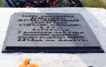
A small detour to the side was made at the request of relatives to find a monument to the families of metallurgists from the Barrikady and Red October plants who died during the war in these places" who were evacuated from Stalingrad.
In 1942, not far from the Janibek station (now located on the territory of Kazakhstan), at the Vengelovsky crossing, a train carrying civilians was bombed by fascist aircraft.
![]()
So we finally found this place. It turned out to be right on our route to Elton.
This is a small public garden with mass graves and monuments on them dedicated to the workers of the Stalingrad factories and their families.
![]()
![]()
Our task was to find the name of our relative’s grandfather, who died during an enemy raid. But, unfortunately, there were no names on the stele.
About half an hour later we entered the village of Elton. The place of our temporary stay was accommodation, booked in advance by telephone (about two weeks before the intended trip). We found the phone number on the website www.elton34.ru.
Friendly Marina assured us without unnecessary formalities that seats were reserved for us. The cost of living per person is 200 rubles per day.
About 5 minutes after entering the village we were there. And the hospitable hostess showed us where we would live. The room had everything you needed: beds, bedding, TV, refrigerator, air conditioning.
True, all the amenities were in the courtyard (toilet and shower outside). As I understand it, there are certain problems with water in the village.
It was possible, of course, to stay at a hotel. But, probably, it would be much more expensive, but not much more comfortable (it was not possible to find any intelligible information about the conditions and cost of living in a hotel).
Therefore, given the short duration of our stay, we decided to endure temporary inconveniences and save a little on accommodation.
There are only two hotels in the village of Elton.
The first is a small hotel with two rooms and amenities also in the courtyard on the territory of the Eltonsky Natural Park (here you can also arrange an excursion).
The second hotel on the territory of the Elton sanatorium. I don’t presume to judge the degree of comfort of living, I just don’t know. Probably, due to the reconstruction of the sanatorium and the construction of new modern buildings, the conditions and service will significantly change for the better.
As an option - it was possible to set up a tent camp on the shore of the Chapaevsky pond(by the way, the only fresh water reservoir in this area).
But somehow we did not dare to take this step and chose more comfortable conditions - an overnight stay in the private sector.

The power problem was easily resolved. We took with us the necessary supply of food, and the house had a refrigerator and microwave.
According to reviews from vacationers in the same guest house, it was possible to have a cheap and tasty lunch or dinner in the cafe with the romantic name “Laura”.
Historical background
The village of Elton is located in the Palassovsky district, approximately 340 km from Volgograd and borders on Kazakhstan.
This is a small town and there is no special entertainment here.

Lake Elton, located on the territory of the Elton Natural Park national conservation area, is the main attraction of these places.
And if it weren’t for this unique lake, it’s unlikely that anyone would go for a weekend to this not-so-close place in the east of the Volgograd region.
It's a shame. But even now, few people know that in our country there is such a miracle lake with amazing miraculous properties. And there is absolutely no need for those suffering to be cured of many ailments to go to Israel to the Dead Sea. This can be done by visiting Lake Elton and experiencing the effects of its amazing healing mud and water. Moreover, I note that this can even be done for free.
How the weather almost ruined our plans...
And so we, having quickly had a snack and dropped our things, got ready to go to the goal of our trip - Lake Elton.
True, one unforeseen circumstance immediately arose on our way, which threatened to derail our plans. And our trip could have ended for us before it even began.
The day before it rained heavily in the village, one might even say a real tropical downpour. The dirt road that led from the village to the lake (approximately 7 km) turned out to be completely washed out, and, given that the soil here is clayey and saline, the risk of driving through without getting stuck was very high.
The vacationing residents of Marina’s hospitable house as one began to dissuade us from such a risky step. Even more powerful machines do not always cope with the very sticky and heavy mud in this area. And our faithful “Moskvichek”, battered by years and distances, threatened to get stuck forever in the Elton mud.
We were terribly disappointed: to cover a distance of 340 km and return home without seeing what it was all about.
No, we did not agree to this and unanimously decided to take the risk. The bright sun was shining in the morning and somewhere after 11.00 we set off, firmly deciding to get to the lake: if we didn’t get there, we’d get there on foot.
In the next part you will learn how we finally got to .
To be continued…