List of personal equipment on storage. Kodar. Kadar Mountains, hiking in the Kadar Mountains, holidays in the Kadar Mountains The highest altitudes of the Kodar Mountains
In the article I will post a list of equipment for a summer hike to the Kodar ridge, with detailed explanations of why and how. At the end of the article I will post a link where the short list can be downloaded in RTF format, fortunately it will be useful for any summer hikes in the mountains, with minor changes
Let me make a reservation right away that I do not include a special mountain equipment to overcome difficult passes and peaks. Such equipment is selected based on the complexity of the planned obstacles. In the summer, passes and peaks up to 1B inclusive, with due care, rope guarding, and therefore the use of “iron”, do not require. As for crossings, the issue is quite debatable. Of my 6 summer hikes along the Kodar, fixing the railings during crossings was carried out twice. Once it was a railing when crossing a log, the second time it was a full-fledged crossing across the Middle Sakukan during a flood. Basically, the whole problem is that if the conditions really require establishing a crossing, then for the one going first this idea is somewhat suicidal in most cases. It becomes easier to lose a day by rising higher, or to wait (usually until the morning) for the water level to drop significantly. Another question is that during rescue operations there is not much choice, but the likelihood of such with good planning and execution is low. Hence the debatable question for groups walking simple routes - whether to take “extra” weight with them. In subsequent articles I will definitely touch on this issue, but in this material I will only outline my position on personal equipment of a non-special nature.
- Backpack.
Everything is more or less clear with him. It should be appropriate for the planning of the trip and be convenient. The same requirements apply to displacement, which will depend on your approach to food, the quantity and quality of equipment and, in general, what lies from the backpacks in your pantry. Personally, if I’m not testing outdoor products, I usually prefer an ordinary 125 liter backpack with the valve left at home. Basically, in 2015, on a three-week summer hike around Kodar, four of our six participants walked with backpacks of less than 75 liters. That is, it all depends on planning and willingness to sacrifice a certain sybaritism. Well, and how much you are willing to eat so as not to carry excess weight.
- Rain cover for backpack.
Unfortunately, there is a lot of rain in Kodar in summer. And sometimes there are even a lot of them. No, droughts also happen, but rarely. Basically, I can promise that you will walk in the rain a lot. Accordingly, it is better to have a waterproof cover on your backpack, rather than a moisture-proof one. Another question is that many modern backpacks already have waterproof fabric, which means you can save on the weight of the cape.
- Sleeping bag.
There is absolutely no difference whether it is down or synthetic, the main thing is that the lower limit of comfort should not be higher than +4...+3 degrees. When spending the night above the forest zone, temperatures of 0...-3 degrees are not uncommon, but the real cold usually breaks through on passes and on glaciers. I would not recommend spending the night on wide plateau-like passes and under the very glaciers; it is better to go a little lower from them and set up camp behind the moraine ridges. Otherwise, you can “catch” up to minus 10 degrees with “half a meter of partly cloudy clouds on the tent,” although this is rare. On the plateaus characteristic of the eastern part of Kodar, rains at a temperature of +2...+3 degrees can easily freeze a group, and this temperature is quite normal for altitudes above 2200. For example, the Khadatkanda pass is located at an altitude of 2260 meters above sea level and very idyllic... in good weather. For groups passing through it (every couple of years someone passes there), it is considered quite normal to spend the night on the pass, fortunately the fabulous views and the presence of water completely allow this. When planning these options, you should consider the need for a wind-resistant tent with a skirt to ensure a normal temperature difference between the inside and outside of the tent.
As a rule, in a normal tent the temperature difference allows a slight minus outside to fit into the comfort range sleeping bag+4...+3 degrees, which is why I consider it the lower limit.
- Rug.
The standard 8 mm foam is enough everywhere in August. I'll say more - if you don't stand base camp on rocks, a thinner one, 5-6 mm, will suffice. I generally use 3 mm, but everyone tells me that it is not good. Apparently, like a leopard, I’m just not supposed to freeze :)
- Hermetic bag or bag for a sleeping bag and dry clothes.
As I mentioned above, it rains a lot on Kodar, so I promise that the insides of the backpack will still be wet with any cover. In addition, there is always the option of flopping at the crossing. And there are many crossings on Kodar.
- Walking boots.
Trekking is a must. You can only walk in ankle boots and mesh sneakers. Kodar is characterized by two phenomena - very sharp stones and an abundance of water. Shoes should be durable and have fabric inserts like . The proper design of the bot will allow it to dry easily and disturb the owner to a minimum. Why I don’t like ankle boots and rubber boots with swamp boots on hikes, I wrote in.
- Gaiters.
The purpose of the gaiters in our case is as follows:
- Protects the upper part of the boot from damage when walking on rocky screes. This is weak protection for boots, but, nevertheless, it is there. This is usually relevant for shoes with a “mesh” upper – various options for lightweight trekking.
- Protects paws from snow and dirt, as well as from small pebbles and twigs getting into them through the top of the boot. They also serve as short-term protection against water pouring into the boots through the top.
- Protects the bottom of the trousers from abrasion.
- Additional protection against hypothermia when passing through fords and deep snow.
- Bivvy shoes.
Necessary for work at the camp, while the main shoes are drying, and its owner enjoys dry socks - but on a hike, a little is all you need for happiness. Shales will also work, but I think EVA galoshes are the best option.
- Trekking socks, 3-4 pairs.
I wrote in detail about why trekking socks are good.
- Thermal underwear of the first layer, moisture-wicking, set.
When you go deeper into the mountains, you will most likely rarely take off your thermal underwear. There's a second skin there. The lower part of the termukha is especially important, the task of which is primarily to save the owner from hypothermia in numerous fords, the waters of which flow out of the glacier a couple of kilometers away.
You can read more about thermal underwear, its functions and the difference between layers in.
- Walking trousers.
Everything is simple with them. They must breathe and snow should not stick to them. You also need at least some adequate margin of safety. I promise that after the hike, your pants will be completely covered in resin and it’s not a fact that you will wash it off :)
- Fleece.
Once upon a time, back in ancient, ancient times, some other strange piece of clothing was used - a sweater. It has sunk into oblivion and now barely looms, shrouded in the haze of burnt porridge, in our memory, overloaded with information about new materials. There are those who stubbornly remain conservative, posing as experienced and claiming that wool is much better than Polartec products. However, know that if an old-schooler does not knit a sweater himself, then he is not a real sneaky tourist, but only pretending to be one :)
I use Polartec Micro fleece; in my size it weighs only 160 grams.
- Route jacket.
Let me remind you again that on the Kodar ridge, in most cases, except for bears, unforgettable rains await you. I sympathize in advance and with all sincerity advise you to buy a membrane jacket for a hike, at least from an inexpensive one. Yes, and it will also be covered in resin, which you will not be able to wash off later.
- Down jacket.
In principle, a down vest will do. You can take the lightest down jacket, as long as there is one. This is the first clothing for camp at near-zero temperatures. In addition, lunches, stops and snacks near glaciers and passes when the wind blows there, without a down jacket, are fraught with the most unpleasant colds.
- The hat is warm.
It is an extremely necessary addition to a down jacket.
- Lightweight headdress.
I recommend a cap or panama with a wide brim. In general, solar activity in summer on Kodar is low, no sunglasses or sunscreen are required, but a Panama hat or cap is good when using a mosquito net.
- Mosquito net.
The most important means of survival in these harsh lands. I advise you to take one or two spares per group. Frame mosquito nets will be inconvenient in the thickets of elfin wood; it is better to take simple ones. No other remedies for midges will help. IN warm years the midge will accompany you everywhere, right up to the very passes, and you will only be able to rest from it if you are on the three-thousand-meter peaks of Kodar.
My partner and I once walked without mosquito nets for 18 days. Then the Buryats seemed to take us for one of their own.
- Work gloves, 2 pairs.
I don’t recommend taking expensive sports ones - you’ll still tear them and cut them with razor-sharp stones. I even prefer to wear leather perforated fingerless ones over my workers.
- Helmet.
It is needed everywhere on moraines and, even more so, when passing passes from 1A. On Kodar it constantly flies from above, and hitting your head on a stone will also be unpleasant. It’s not unpleasant for you yourself, but for your comrades who will drag out the body later. A construction helmet is also suitable.
- Headlight.
No spare batteries are required, just one fresh set is enough. I wrote in detail about choosing a flashlight for a hike.
- Personal first aid kit.
Everything has been written about her in detail.
- Knife.
You don’t need a machete, otherwise everyone has their own felt-tip pen to suit their taste and color. I haven’t written about choosing knives for a hike yet, but I will try to correct this omission in the future.
- Wristwatch.
I recommend electronic ones and definitely waterproof ones.
- Notepad and pencil.
Even if you don’t like keeping a diary, you can write down personal grievances against your comrades there. In fact, one of the problems have a nice hike in such an unfavorable climatic zone is that the majority have absolutely no idea what to do with themselves at camp and during weather delays. Nowadays, e-books and storage devices for recharging have become popular. For example, reading aloud the classic tourist work “The Evil Spirit of Yambuya” significantly increases the tone of the team.
Well, there are only a few little things left:
- Mug, spoon, bowl.
- Documents, set, in germ.
- Toilet paper in a bag or sealed bag.
- Means for lighting a fire.
- Repair kit - threads, needle, patches for clothes.
- Emergency rescue blanket.
- 0.5 liter plastic bottle as a flask and container for collecting berries.
- Whistle for self-defense attempts against bears.
In general, this is the necessary minimum, which, as I already said, can be used successfully for many summer hikes with similar conditions.
You can download the short list in RTF format from me
Transbaikalia, on the border of Chita and Irkutsk region From Evenk, Kadar "rock, cliff; rocky mountain".
Geographical names world: Toponymic dictionary. - M: AST. Pospelov E.M.
2001.
Kodar ridge on the N. Transbaikalia in system Stanovoy Highland , continues to NE. North-Muya Range , separated from it by a deep gorge of the river. Vitim
Dictionary of modern geographical names. - Ekaterinburg: U-Factoria. Under the general editorship of academician. V. M. Kotlyakova. 2006 .
See what “Kodar” is in other dictionaries:
Kodar ... Wikipedia
A ridge in the central part of Transbaikalia, in the Stanovoy Highlands system, a continuation of the North Muisky Range. in the Chita and Irkutsk regions. Length approx. 200 km. Height up to 2999 m. Glaciers (approx. 18.8 km²). Larch forests give way at an altitude of 1500–1700 m… … Big Encyclopedic Dictionary
KODAR, a ridge in the central part of Transbaikalia, in the Stanovoy Upland system, a continuation of the North Muisky ridge in the Chita and Irkutsk regions. Length approx. 200 km. Height up to 3072 m. Glaciers (approx. 18.8 km2). Larch forests give way at altitude... ...Russian history
A ridge in the central part of Transbaikalia, in the Stanovoi Upland system, a continuation of the North Muisky ridge in the Chita and Irkutsk regions. The length is about 200 km. Height up to 3072 m. Glaciers (about 18.8 km2). Larch forests give way at an altitude of 1500... ... encyclopedic Dictionary
Kodar- (Chit. region) archive In Northern Transbaikalia, on the border of the Chita and Irkutsk regions. according to Evenk. kadar rock, cliff, stone. Here. On hr. Kodar, the highest rocky chars are located, the peaks of the entire Transbaikalia... Geographical names of Eastern Siberia
Mountain range of the Stanovoy Highlands in the Chita and partly Irkutsk regions of the RSFSR. It is a continuation of the North Muisky ridge, stretches almost 200 km to the river. Tocco. Height up to 3000 m. Composed of granite gneisses and crystalline... ... Great Soviet Encyclopedia
Expedition routes: Kodar ridge (mountain)
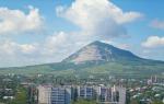
In the north of the Chita region, where the territories of Yakutia and Buryatia, Irkutsk and Amur region, there is a country of contrasts and surprises - the Char Basin with the surrounding Kodar and Udokan ridges. More recently, only a geographer knew about these places, and the word “tourist” was completely absent from the dictionary local residents. Now books are written about Kodar, Udokan and Char, and their beauties are shown in films. Many people dream of coming here. The popularity of this region of Transbaikalia is explained by the fact that it has several strong “magnets” that attract a restless tribe of travelers from all over Russia. First of all, this is the Kodar ridge, which stands out sharply among the surrounding Siberian plateaus and mid-mountains with its clearly defined alpine relief. Here it is highest point Transbaikalia, here the mountain range reaches a two-kilometer scale, here “towers”, “pyramids” and “fangs” of rocky peaks rise menacingly. Amateur mountain travel In Kodar you can go through five or six passes in one trip, half of which on the tourist scale will be rated at least 2 A category of difficulty. In other words, Kodar is the “Trans-Baikal Alps”. In addition, Kodar is the only ridge in Transbaikalia that has modern glaciation. Three dozen Kodar glaciers in size (length up to 2 km or more) and in total area exceed the known Ural glaciation. Discovered only in the 50s, the glaciers immediately became the highlight of the area.
The most powerful uplift of Kodar, which carries almost all the glaciation of the region, is located in the region of Central Kodar, which stretches from the Leprind Lakes to the northeast along the Apsat Lane for almost 100 km, reaching its greatest height in the area of the Upper and Middle Sakukan rivers. In the upper reaches of the Upper Sakukan there is the highest point of the Kodar Range and the entire Transbaikalia - the BAM peak (3073m). In the vicinity of the BAM peak, most of Kodar's interesting objects from a tourist point of view are concentrated: the peaks Leningradets (2780m), Glaciologist (2773m), Chara (2815m), Lednikovy (2807m), the Snezhny, Gelfgata, Vodopadny, UPI, Ptichy, Spartak passes. This section of Kodar is difficult to pass. The passes are difficult and dangerous with rocks. The slopes are rocky, there are often walls and cliffs, and glaciers of a large area. Majority tourist routes on Kodar pass through this interesting area, intersecting in the area of the GMS base in the upper reaches of the Middle Sakukan.
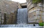
The route along Central Kodar is designed for tourists who are not making their first trip to the mountains. Participation requires basic mountain climbing and rope handling skills. The route includes several passes of 2 A difficulty category. The group's path runs through rocky areas, glaciers and impassable river valleys. Several overnight stays are organized in the high mountain zone above the forest line, including on a glacier. It should be noted that there is an extreme abundance of midges in this area. The route ends at Chara Sands, which are located 5 km west of the village. Chara and 8 km northeast of the village of Novaya Chara, between the Upper and Middle Sakukan rivers. Chara Sands (their area is quite large - 45 sq. km) is an extraordinary place. Everything here is like in a real desert. But there is also something that you won’t see anywhere except Transbaikalia: next to the warm yellow sand there is blue cold ice; among the sandy ridges you suddenly come across an oasis, but not with palm trees, but with northern larches. Around the sands are mountains, even in summer covered with snow; The dunes break off into swamps and lakes. In the southwest of the sands there is Lake Tayozhnoe, and in the northeast - Alyonushka. Here you can relax, wash away the fatigue of the hike, and just lie on the shore. You can go on an excursion to the desert or drink mineral water from a spring near Lake Alyonushka.
duration of the active part of the route is 9 days; The length of the route is 90 km.
KODARA GLACIERS, a natural monument of federal significance (Decision of the State Planning Committee of the RSFSR No. 199 of September 24, 1986) in the Kalarsky district. Glaciers discovered in 1958 by geographer V. S. Preobrazhensky are the only place modern glaciation. More than 30 glaciers are located in the center. parts of the archive Kodar on ter. Irkutsk region and Zab. cr. The Irkutsk part of the glacial region is part of the Vitimsky state. reserve. Zab. part is a natural monument with total area 6375 hectares. Glaciers are located 40-60 km to the west. from the village Chara on the axial watershed part of the ridge at the sources of the Bas. pp. Chara (rivers Upper and Middle Sakukan, Byurokan, Kondrat, Taezhnaya) and Vitim (rivers Sulban, Oleniy, etc.) bass. The largest are the glacier named after. Soviet geographers and the glacier named after. E. Bobbin, also large areas have a saddle glacier named after Preobrazhensky , glacier named after Nina Azarova , glacier named after Kolosov. Most glaciers are located in the upper reaches of valleys and in glacial cirques (circuses) open in the northeast. side, in the cirque-like upper reaches of trough valleys (river valleys formed by a mountain-valley glacier). A feature of the glacial cirques of the ridge. Kodar have steep, almost vertical slopes, while the classic glaciers of the Alpine type have cirques that are significantly expanded at the top. parts compared to the bottom. Wed The thickness of the glaciers is 54 m, the volume of ice is 0.83 km 3. Firn line of glaciers (height, below the cut long-term compacted snow (firn) does not turn into ice) on the ridge. Kodar passes at an altitude of 2200-2500 m, which is approximately 1000 m below the classic level of perpetual glaciers. With a positive heat balance, there should be no glaciers in this region, and this is another of their unique features. Modern glaciation is slowly degrading. On ter. natural monuments are subject to environmental protection. glacier complexes and rare species animals listed in the Red Books of the Russian Federation, Chit. region and Aginsk. Boer. auto env.: black-capped marmot and bighorn sheep. The natural monument is actively used as a tourist site (extreme, ecotourism, photo tourism, etc.): more than 30 sports tourist routes pass directly along its territory, attracting more than 2,000 people annually. And foreign tourists. The organizer of hikes and excursions is the department. Local History and Tourism Kalarsky local history museum. In the projected Kodar national park (see Kodar Glacier Region) the monument is assumed to be the core of the territory.
Lit.: Preobrazhensky V. S. Kodarsky glacial region(Zab.) // Glaciology (IX section of the program of the international geophysical year). - M., 1960. - No. 4; Catalog of Glaciers of the USSR. - L., 1972. - vol. 17, Issue. 2; Dolgushin L. D., Osipova G. B. Glaciers. - M., 1989; Plyusnin V. M. Glaciers of the ridge Kodar // Udokan: preparation of ter. for development (ecological and geographical aspect). - Chita, 1992; Red book Cheat. region and Aginsk. Boer. auto environment: Animals. - Chita, 2000; Red Book of the Russian Federation: Animals. - M., 2001.
Small Encyclopedia of Transbaikalia: Natural heritage/ ch. ed. R. F. Geniatulin. - Novosibirsk: Science, 2009. - 698 p.