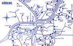
Description and map of hiking routes through the valleys of Cappadocia. List of valleys in Cappadocia: map with routes and brief description Photo of the Rose Valley
Wonderful creations of Mother Nature,
especially when he gets too excited.
You can't grasp it with your mind.A. Baricco “Sea-Ocean”
Cappadocia was probably the #1 place we wanted to visit in Turkey. Those who were here will understand why, those who were not, read on.
We set off towards the Turkish miracle from Ankara by bus from the ASTI bus station. The ticket cost 35 lire, the ride was four hours. The journey took place in two stages: a large bus took us to the bus station in Nevshihire, where we boarded a small minibus and proceeded to the village of Goreme, which we chose as the starting point for visiting the Cappadocian valleys. Some tourists stay in Nevsehir and other towns, but the majority prefer to stay in Goreme, because the location of this village is much more convenient for walking without the use of additional transport.
Let me tell you right away that we had a lot of time, so we walked everywhere, only hitching rides a couple of times.
IN Goreme, after a short search, we checked into Atak Hotel. We asked for the simplest and cheapest room, which, accordingly, turned out to be the smallest. A day's stay cost 40 liras. The hostess was very surprised that we were staying for a whole week; apparently a rare animal stays here longer than two or three days.
In the end, we ended up with five full-fledged walks through the valleys, although it seems that we could have spent a month leisurely wandering through these unique places and exploring every centimeter.
I won’t write a lot about Cappadocia, I will limit myself to a minimum of impressions and practical information, because this is the place that you need to see with your own eyes, this is the place where you need to come and go, go, go, looking around. So I recommend, I wish, no, I strongly advise everyone to visit there :-)
- Day 1, Cappadocia: Meskendir valley, Red and Rose valleys, Cavusin city
- Day 2, Cappadocia: Pasabag, Zelve and Dervent valleys, Urgup city
- Day 3, Cappadocia: Pigeon Valley, Uchisar city and Valley of Love
- Day 4, Cappadocia: Görkünder, Zemi valleys and failure in the Balkan valley
- Day 5, Cappadocia: Goreme Open Air Museum
General scheme of Cappadocia
Goreme

Cappadocia: Meskendir Valley, Red and Rose Valleys, Cavusin city
We decided to start the first day by spying on the main tourist attraction of Cappadocia - flying balloons. Subsequently, I got the impression that watching them from the outside was much more interesting than being on board. Cost of a hot air balloon flight: about 200 euros per person for one hour. The basket fits about 15-20 people.

Having met the dawn, we went for a walk along the intended route, namely along the valleys located east of Goreme. Today we were waiting for the Meskendir Valley, Red and Rose Valleys.
The first one on our way was Meskendir Valley(Meskendir Vadisi). She pleased us with an unimaginable landscape of volcanic origin.

It is difficult to get lost here: the well-trodden path, diagrams and signs will not allow this.


Along the way there are cafes where you can drink tea, coffee or orange juice. The prices there, it should be noted, are tourist prices.

Once upon a time, people lived in these valleys, and they lived there right up to the beginning of the twentieth century; later, some dwellings were converted into dovecotes.

From the Meskendir valley we smoothly move into the next one, Red Valley(Kızılçukur Vadisi). Here other colors begin to predominate, as you might guess from the name, reddish. Here you can admire real gnome houses))

From here, from above, a panorama of the surrounding spaces opens up. In this place we met the most tourists, because there is an observation deck nearby, where they are brought on huge buses.

From Krasnaya we head to Rose Valley, which has two spurs: Güllüdere I and Güllüdere II. Everything around becomes a softer pastel color.

Along the way there are many churches carved into caves; in some of them you can see preserved frescoes. All of them are amazing in size and complexity of shapes; I can’t even believe that they were all created by people.


From the height there is a magnificent view of the city.

In addition, in Çavuşin you can see the famous Cappadocian “stone pillars” peribajalari. In English they are called fairy chimneys, which translates as “fairy fireplaces”. Popularly known as “mushrooms”))

– in my opinion, the most interesting valley in Cappadocia near Goreme. Length – approximately 1.5 km. This valley has the longest tunnels, at the end of it there is a large climb - you have to climb up metal stairs. The valley ends with an exit to the observation deck on Aktepe Hill.
- – located 95 km from Goreme (if you go through Derinkuyu), near the village of Ihlara. One of the most equipped and interesting valleys in Cappadocia. There is an entrance fee to the valley. The total length is 14 km. The length of the most equipped part for walking is about 3.5 km. The trail goes along the bottom of a very deep and picturesque canyon, which contains a huge number of rock churches with wonderful frescoes. In the 50s, the mummy of a virgin was discovered in the valley. It is convenient to combine a walk through the valley with a visit to the underground cities of Derinkuyu and Kaymakli. It is ideal to go there overnight and rent a car.
The map is clickable. You can download it.
- – located next to Cavusin, has two spurs, which are called the Rozovaya-1 valley and the Rozovaya-2 valley. Very popular among tourists. It has several interesting churches.
- – a picturesque and very popular valley with a length of 4.9 km. It includes the small Honey Valley, the famous Love Valley (Valley of Love-1) with phallus-shaped (finger-shaped) rocks and, in fact, the White Valley itself, which is located between them. There are no churches in the valley.
- Valley of Love-1 or Love Valley- the famous valley, which is depicted on advertising brochures. It is the hallmark of Cappadocia. It is famous for its phallus-shaped (finger-shaped) rocks, the same as in the Görkünder valley (Valley of Love-2). Part of the White Valley. See its description in the description.
- – starts from the Kaya campsite and stretches to Cavusin. It consists of two parts: the first, more interesting part is a canyon with a periodically drying stream; the second, less interesting – the wide “plain” part. A walk through this valley is usually combined with a visit to the Red and Rose valleys, and the most persistent ones add the Sabel Valley to this list.
- – an easy, wonderful valley for walking with excellent vantage points and many “wild” churches. It starts from the road to the Goreme Museum and goes out into the Meskendir valley onto a dirt road 1.5 km from Çavuşin.
- – the valley has the largest number of rock dovecotes. The first part of the valley, more popular for walking, stretches from Goreme to Uchisar (1.7-2 km). But most of the dovecotes are in the second part of the valley (2 km), which is visited less often by tourists. This valley is included in the Green Tour.
- – the trail starts from Goreme and leads to the Nevsehir – Urgup road. One of the longest (5.6 km) and secluded valleys. Most of it runs along the bottom of the gorge. There are several churches in the valley, of which only a few can be visited at the very beginning of the journey.
Other valleys
- – a small (0.5 km) and easy-to-traverse valley near Goreme, which is often called the Valley of Love-2. The shapes of the rocks are especially impressive in it: they are the same as in the Valley of Love-1, only it looks smaller. There are no churches in the valley.
- Honey Valley- a small valley that is part of the White Valley. It is distinguished by its remarkable streamlined rocks and rocky “swells”. Named for the characteristic honey color of the rocks. See its description in the description.
- Babardzhik Valley– located approximately 2 km from Goreme. It is a continuation of the Zemi Valley. It is rarely considered as a separate valley, but rather as the Zemi Valley. This is the most interesting part of it. See its description in the description.
Which valleys to visit first?
The most interesting valleys in Cappadocia: Red valley, valley Ihlara and valley Love-1(can be safely replaced with valley Gorkünder (Love-2)).
Depending on how much time you have to travel, you can recommend different options.
- If you have 1-2 days, be sure to visit Görkünder, the Red Valley and the Sabel Valley.
- If you have 3-4 days, add the White, Rose and Meskendir valleys to this list.
- If you have 6-7 days to Cappadocia, be sure to go to the Ihlara Valley with an overnight stay and go through the Zemi Valley.
Life hack 1 - how to buy good insurance
It is very difficult to choose good insurance. Therefore, I have compiled a rating for travelers. I take reviews, opinions and latest information for the rating based on my experience, as well as by analyzing travel forums and specialized sites.
Cappadocia is known throughout the world for its unique rock formations and caves, which were used by Christian settlers centuries ago. While many people prefer to see the landscapes from above, it is equally interesting to walk through the valleys on your own.
Near the settlements of Goreme, Uchisar and Cavusin are the most interesting valleys of Cappadocia. They differ in beauty, complexity of landscape, travel time and even color. Some are the most popular, while others are completely deserted. Depending on your health and physical fitness, you can choose trekking of any difficulty level. The “average” tourist will be able to travel around all the valleys in 2-3 days.
The difficulty was not even in our endurance, but in orientation on the terrain. For your convenience, here is a map of the main hiking routes along the valleys of Cappadocia:
The valley closest to Goreme. Starts right behind the open-air museum. So called because of the isolated sharp rocks that resemble swords or daggers. It is considered the shortest valley, but there are many ancient stone huts and a deep ravine into which you can go down. You can get around Kiliclar Vadisi in 1-2 hours.

Rose, Red Valleys
The most famous valleys in Cappadocia. We didn’t notice much difference between the Red and Pink valleys (there are two of them: Gulludere-1 and Gulludere-2). The rocks are approximately the same pink color, somewhere darker, somewhere lighter.
Walking through the valleys, we came across abandoned vineyards and pumpkin fields, houses in which people lived quite recently (who left the now abandoned vineyards):

More recently, people lived in this house; even a water barrel still stands near the entrance

Abandoned vineyard near the house
Ancient rock churches, the frescoes of which are practically no longer visible:

There are also large churches, for example, like this one:

Entrance to the huge cave church:

Along the way, a couple of times we came across small cafes where you can drink orange juice or tea.

Freshly squeezed orange juice for a dollar and a million dollar view
And there are also abandoned cafes: this is not surprising, because a fairly small percentage of tourists in Cappadocia decide to go on long walks in the mountains, so such a cafe brings in practically no income.

Abandoned cafe
Climbing these mountains, you feel like the ruler of the world: from above you have indescribable views of the valley and not a single living soul in sight!


A couple of times we came across clearings with drying grapes, slowly turning into raisins under the scorching September sun:

All photos from Rose Valley:
Love Valley
This valley is famous for its thin and long cliffs with triangular tops. A more appropriate name for this valley is the valley of the phalluses, but it is used exclusively among tourists.

Çavuşin Fortress (also known as the holey or cheese rock)
The fortress once served as a home for many families, a sort of analogue of a modern high-rise building or apartment building.


In addition to the usual residential premises, there is also a church. The frescoes in it are already worn out. It is clearly visible how diligently the Ottoman invaders tried to destroy the faces on the icons (in the Muslim religion, the image of people and animals is prohibited, and with the destruction of the face, as the Ottomans believed, the soul leaves the icons):


Entrance to the fortress is free.
Pigeon Valley
Another name for it is the valley of dovecotes or the valley of pigeons. Indeed, a great many dovecotes were seen in the rocks of the valley: the locals love these birds. Turns out. Breeding pigeons also has a practical purpose: the production of pigeon droppings, which, according to local residents, is the best fertilizer.

The valley is located between Goreme and Uchisar, so it would be logical to combine its passage with a visit to the Uchisar fortress. And here again new forms of rocks!


There is a cozy cafe right at the exit of the valley. We enjoyed drinking tea there and chatting with the owner. When he found out that we were Russians from Samara, he was incredibly happy and said that his car was also from Samara. Indeed, under the tree next to the cafe there was an old red Lada, in which the owner comes to his cafe every day from Uchisar and waits for very rare tourists.

Valley-stream (Zemi Valley)

It is considered the longest valley - its length is 5.6 km. You can visit it together with the Open Air Museum in Goreme. The entrance is literally 100 meters from the museum parking lot. There used to be a stream babbling here, but it has dried up, although in some places it is still quite damp and muddy. Along the way you can see several churches, cells, chimneys.

The Zemi Valley is very easy in terms of difficulty, very beautiful and very uncrowded - there are no excursions or ATVs here.
Meskendir Valley

The length of the valley is 4400 m, it lies in a southwestern direction from Ortahisar to the village of Cavusin. You need to start trekking between the Open Air Museum and the settlement of Ortahisar.
The path is quite long, but very interesting to explore. On the way, you can immediately turn to 3 other valleys and visit several churches. Meskendir is considered the “entrance to the valleys of Cappadocia.” It is known for its unusual rock formations, colorful stones and lunar landscape. The entire journey will take approximately 3 hours.
Rose Valley (Güllüdere)– one of the most popular valleys near Goreme. Included in excursion Red Tour. Strictly speaking, the valley is located closer to Çavuşin, but most often it is visited from Goreme. The valley got its name because of the pink hue of the rocks. It has two canyons (spurs), which are distinguished as the Rozovaya-1 valley and the Rozovaya-2 valley. These two canyons have two different entrances, but then they join together. The valley has churches, dovecotes, grapevines, turtles and lizards.
The valley is designated differently on diagrams and maps. In the English version - Roze Valley. On the waystones the name of the valley is written in Turkish Güllüdere Vadisi, which in Russian sounds like Güllüdere.
Full map with all the valleys can be downloaded on this page: .
Two spurs of the valley, Rozovaya-1 and Rozovaya-2, are located parallel to each other. They stretch from the wide part to the Sunset point on Aktepe Hill. The spur of the Rozovaya-1 valley in turn has two branches, which then converge together.
Length of the valley if you walk through the Rozovaya-1 spur(from Meskendir Valley to Sunset Viewpoint), about 3 km. If you go through the Rozovaya-2 spur(from the Meskendir Valley to the Sunset Viewpoint), the length of the valley will be about 2 km. But if you enter the first spur of Rozovaya-1, and exit through the second spur of Rozovaya-2, you will get about 3 km.
How to find the entrances to the valley
- First option. From Çavuşin, from the rock fortress, we go towards Goreme through the cemetery (300 meters from the fortress to the cemetery). 300 meters after the end of the cemetery there will be a fork - you need the road that goes to the left. Approximately 400 meters from the fork, to the left there will be an entrance to the Rozovaya-1 valley, and after another 500 meters there will be an entrance to the Rozovaya-2 valley. Each of the entrances is marked with a waystone. Near the entrance to the Rozovaya-2 spur there is a seasonal roadside cafe.
- Second option. From Goreme through the Sabel Valley. We pass the Sabel Valley: how to do it. We go down the hill to the dirt road where the cafe is located. There is a crossroads of several roads here. There will be an entrance to the Rozovaya-2 valley directly. If you go left towards Cavusin, then after 500 meters there will be a right turn into the Rozovaya-1 valley. The entrances are marked with waypoints.
- Third option. Through . Closer to the Aktepe mountain (hill) there will be signs to the Rose Valley from the Red Valley.
- Fourth option. The trail, just like for the Red Valley, starts from the Sunset observation deck on Aktepe Hill. You can get to the observation deck as follows. We move from Goreme along the road to Ortahisar (3 km). Then we turn left onto the road to Urgup and get to another left turn to the observation deck (0.6 km). Now we move straight along this road for 2 km. The total distance from Goreme to the Sunset site is almost 6 km. Usually people get here either by hitchhiking () or by taxi.
Important! Read the general visiting recommendations for all valleys: .
Valley travel time: If you don't rush, it will take about 2-2.5 hours. Usually a visit to the valley is combined with a walk through the Meskendir Valley and the Red Valley, sometimes they include the Sabel Valley.
More often they do it this way: first they go through the first, most interesting part of the Meskendir valley (see), then they go to the Red Valley and from it they move to Pink-2 or Pink-1. After which you can go to the fortress in Çavuşin or return through the Sabel valley to Goreme.
By the way, it’s also a good option to enter through the first spur (Pink-1) and exit through the second (Pink-2).
In general, the Pink Valley is inconvenient because it is not straight, like, say, a valley or, and therefore, in order to completely go through it, you need to walk along the same paths several times to visit all sorts of branches. But in general, few people do this - they simply choose one of the spurs and pass through it, considering that the Rozovaya Valley has been visited.
Churches of the Rose Valley (Güllüdere, Güllüdere)
- Church of Three Crosses (Üç Haçlı Kilise) dates back to the 9th-10th century. It got its name from the three crosses carved on the ceiling. There are frescoes in the church.
- Church with quince or Ayvali Church (Ayvalı Kilise) dates back to the 10th century. It is located approximately 1 km from the entrance to the Rozovaya-2 valley, if you walk from the Meskendir valley. The church consists of two chapels, one of which was a tomb. The church has preserved frescoes, but, unfortunately, you won’t be able to see them because it is closed to the public.
- Church with a cross or Khachli Church (Haçlı Kilise) dates back to the 10th century. The church is located near a seasonal cafe. It is famous for its flat ceiling, on which a large cross is carved. The church is located at the top - a wooden staircase leads to it.
- Church of Saints Joachim and Anna (Joachaim-Anna Kilise) dates back to the 7th century. It is located approximately 600 meters from the entrance to the Rozovaya-2 valley, if you come from the Meskendir valley. The church is locked and it is not possible to visit it. There are two small chapels on either side of the church - it is believed that this could have been a monastery complex. One of the chapels presumably served as a tomb.
- Church with columns Direkli Kilise dates back to the 11th century. A large church, the premises of which are connected by tunnels. The frescoes inside have not survived. Located approximately 400 meters from the Church of Saints Joachim and Anne or 1 km from the entrance to the Rose Valley 2 if entering from the Meskendir Valley.