The history of the origin of the name of the Sea of Azov. Sea of Azov - origin of the name. Sea of Azov - climate and temperature conditions
To our ancestors who inhabited ancient Rus', The Sea of Azov was known back in the first century. But they called it differently - affectionately the Blue Sea. It may well be that our great poet Alexander Sergeevich Pushkin, who visited Tmutarakan (former name) and wrote the “Tale of the Fisherman and the Fish”, still popular among both children and adults, had in mind the hut of an old man and an old woman with a broken trough exactly on its shore.
He also called him “blue”!? And “Near Lukomorye there is a green oak tree” from the poem “Ruslan and Lyudmila”? - this is also about the Blue Sea. The truth about the one that merged with the Black Sea through the Kerch Strait. And the place where our warm southern seas rush into each other’s arms was called Lukomorye! This is not far from the resort on the shores of the Temryuk Gulf of the Azov Sea, which is especially loved by Muscovites: there is much more sun here than in Sochi and Gelendzhik (it shines 280 days a year) plus magnificent sandy beaches plus a lot of attractions and entertainment. But it is also surprising that, upon returning home, tourists quite often confuse which seas they swam in: it’s just a stone’s throw from the Sea of Azov, and the temptation to swim in both is strong! This is what vacationers do with great passion!
But only Russians lived on the shores of the Sea of Azov. As then, so to this day, their shores were and are inhabited by representatives of other large and small nations. Therefore, say, the Greeks, even now living in compact settlements with a pronounced Hellenic culture and Athenian architecture, called this shallowest body of water in the world - Lake Meotia. The Romans - the Maeotian swamp. Turks - Bahr - el Assak or Bahr-y Assak, which literally translates as the dark, blue sea.

It must be said that throughout its history, the Sea of Azov was renamed several times. Sometimes it was called Samakush, sometimes Salakar, sometimes Mayutis. And as the chronicles, in particular of Pimen, dating back to the seventeenth century, testify, the Sea of Azov became consonant with the city of Azov founded on its shore. At least in the eighteenth century, this name was firmly entrenched in it. Hence the villages derived from it - Azovskaya, Priazovskaya, the city of Novoazovsky or the village of Priazovsky.
Taking into account the fact that the Sea of Azov is still connected to the Black Sea through the Kerch Strait, it can rightfully be called a semi-enclosed sea. It splashes in eastern Europe. This is, let us emphasize once again, the shallowest sea in the world. Its average depth ranges from 6 to a little over seven meters, the maximum exceeds thirteen and a half meters.
Like the Black Sea, the Sea of Azov is connected by straits and seas to the great Atlantic Ocean. In this sequence: through the Kerch Strait - with the Black Sea, through the Bosporus Strait with the Sea of Marmara, then through the Dardanelles Strait with the Aegean and Mediterranean Seas, and through the Strait of Gibraltar it merges with the Atlantic Ocean. Quite muddy rivers flow into the Sea of Azov, plus they are not so deep and have silt deposits at the bottom. Therefore, unlike the Black Sea, the Azov Sea is not so transparent - from 0.5 to 8 meters of visibility, depending on weather conditions.
Dimensions and features of the Sea of Azov
Its surface area is 37,800 square kilometers. To these you can add another 107.9 square kilometers, which fall on the islands and spits. The coastline exceeds 1,470 kilometers. The largest length is 380, the largest width is 200 kilometers. The drainage area is 586,000 kilometers.
Salinity exceeds 14-15 percent. Unlike the Black Sea, the water contains less chlorine and calcium, but it is richer in carbonates and sulfates. The average annual water temperature is about 11 degrees, in the summer it warms up to 24-26, but in some places it even reaches 30-something. In winter it can cool down to one with a plus sign or to zero. At lower air temperatures, ice even forms, which enters the Black Sea through the Kerch Strait. Adding extra trouble to sailors, especially in the Novorossiysk region, when in winter it breaks through the surrounding mountains North wind bora, which binds the hulls of ships with an ice shell.
Marine life
Sea of Azov - real paradise for fishing lovers. There is no other body of water in the world richer in fish! There is six and a half times more of it here than, for example, in the Caspian Sea. Forty times more than in the Black Sea. And 160 times more than in the Mediterranean Sea. There are more than a hundred species and subspecies of fish. There are so-called migratory species that enter rivers to spawn - beluga, stellate sturgeon, herring, and fisherman. There are semi-anadromous species - which enter rivers to reproduce and even spend the winter in them - carp, bream, ram, pike perch, etc. In the desalinated waters of the sea, sterlet, bleak, pike, silver carp, and ide are found. Well, who among the fishing enthusiasts does not know such inhabitants of the Azov Sea as red mullet, mullet, horse mackerel, mackerel, pelengas from the mullet family or anchovy, which the same Muscovites take lightly salted or salted in large containers to their native lands and treat their relatives and friends. With boiled potatoes - the most relish!
There are also larger inhabitants in the sea. For example, the porpoise is the Azov dolphin. It is also called chushka, pyhtun. They live either in pairs or in flocks of up to ten or more individuals. Females are larger than males - 90, 150 centimeters. Weighing thirty or more kilograms. They live 25-30 years. In the floodplains of the estuaries adjacent to the sea there is a lot of waterfowl; among the reeds you can see wild boar and fox and muskrat, brought here from North America.
Holidays at sea
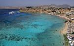
We have already said that the length of the coastline of the Azov Sea reaches almost one and a half thousand kilometers. Of course, most of them are located on magnificent sandy beaches. And the entire sea coast is an almost continuous recreation area with resort towns and villages, thousands of sanatoriums, boarding houses, recreation centers, children's health camps, tent cities, hotels, inns, a huge private sector. For example, the same world-famous Taman in 2001 received the status of a resort of federal significance due to the presence of large quantity healing mud, both extracted from the bottom of salt lakes, estuaries, and extinct or active mud volcanoes.

Silt or mud applications will help you get rid of skin diseases, put your musculoskeletal system in order, help with rheumatism and radiculitis - the range of their beneficial effects for health is very wide, and the procedures can be alternated with swimming in the sea, in which beneficial salts are also dissolved and which is just a stone's throw away: the same salt lake
The Sea of Azov is an inland sea in eastern Europe. This is the shallowest sea in the world, its depth does not exceed 13.5 meters. According to its morphological characteristics, it belongs to the flat seas and is a shallow body of water with low coastal slopes. The seashores are mostly flat and sandy, only on the southern coast there are hills of volcanic origin, which in some places turn into steep mountains. In terms of distance from the ocean, the Sea of Azov is the continental sea of the planet. The coastline is indented by bays and spits, the territory of which is a protected or resort and recreational area. The shores of the Sea of Azov are low-lying, composed of sand and shell deposits. The large rivers Don, Kuban and numerous small rivers Mius, Berda and others flow into the Sea of Azov.
SalinityThe salinity level of the Azov Sea is formed primarily under the influence of the abundant influx of river water (up to 12% of the water volume) and difficult water exchange with the Black Sea. The water contains very little salt in the northern part of the Azov Sea. For this reason, the sea freezes easily. In winter, partial or complete freezing is possible, with ice being carried into the Black Sea through the Kerch Strait.

The underwater relief of the sea is relatively simple. As you move away from the coast, the depths slowly and smoothly increase, reaching 13 m in the central part of the sea. The main area of the bottom is characterized by depths of 5-13 m. The area of greatest depths is in the center of the sea. The location of the isobaths, close to symmetrical, is disrupted by their slight elongation in the northeast towards the Taganrog Bay. The 5 m isobath is located approximately 2 km from the coast, moving away from it near the Taganrog Bay and in the bay itself near the mouth of the Don. In the Taganrog Bay, the depths increase from the mouth of the Don (2-3 m) towards the open part of the sea, reaching 8-9 m at the border of the bay with the sea. In the topography of the bottom of the Sea of Azov, systems of underwater hills are noted, stretched along the eastern (Zhelezinskaya Bank) and western (Morskaya and Arabatskaya banks) coasts, the depths above which decrease from 8-9 to 3-5 m. For the underwater coastal slope north coast characterized by wide shallow waters (20-30 km) with depths of 6-7 m, for south coast- steep underwater slope to depths of 11-13 m.

Sea currents are dependent on the very strong north-eastern and south-western winds blowing here and therefore change direction very often. The main current is a circular current along the shores of the Sea of Azov in a counterclockwise direction.
FaunaThe ichthyofauna of the Azov Sea currently includes 103 species and subspecies of fish belonging to 76 genera, and is represented by anadromous, semi-anadromous, marine and freshwater species.

Migratory fish species feed in the sea until sexual maturity, and enter the river only to spawn. The breeding period in rivers and or on borrowed land usually does not exceed 1-2 months. Among the Azov migratory fish there are the most valuable commercial species, such as beluga, sturgeon, stellate sturgeon, herring, vimba and shemaya.
Semi-anadromous species come from the sea to rivers to reproduce. However, they can stay in rivers for a longer time than migratory ones (up to a year). As for the juveniles, they migrate from spawning grounds very slowly and often remain in the river for the winter. Semi-anadromous fish include common species such as pike perch, bream, ram, sabrefish and some others.
Marine species breed and feed in salty waters. Among them, species that permanently live in the Sea of Azov stand out. These are pilengas, flounder, glossa, sprat, perkarina, three-spined gnat, needle fish and all types of gobies. And finally, there is a large group of marine fish that enters the Sea of Azov from the Black Sea, including those that carry out regular migrations. These include: Azov anchovy, Black Sea anchovy, Black Sea herring, red mullet, singil, sharpnose, mullet, Black Sea Kalkan, horse mackerel, mackerel, etc.

Freshwater species usually live permanently in one area of a body of water and do not make large migrations. These species usually inhabit desalinated sea areas. Here you can find fish such as sterlet, silver carp, pike, ide, bleak, etc.
The Sea of Azov has no equal in the world in terms of the number of plant and animal organisms. The Azov Sea is 6.5 times more productive than the Caspian Sea, 40 times more productive than the Black Sea, and 160 times more productive than the Sea of Azov. Mediterranean Sea. But in size it is 10 times smaller than Black.
MineralsGeologists unanimously agree that the subsoil of the Azov Sea is very rich. Zircon, rutile, and ilmenite were discovered here. Under the seabed there are minerals containing a good half of the periodic table. In the southeastern part of the sea there are underwater mud volcanoes. Industrial reserves of natural gas have been found in the depths of the Azov Sea.
The smallest, shallowest and most freshwater sea in the world, the Sea of Azov is not inferior to the Black Sea in popularity among Crimean tourists. Warm water sandy beaches, cozy bays - the best place recreation for children and adults. The shores of the Azov Sea are chosen by skysurfers and divers. Despite environmental problems, fishermen are still interested in local waters. In the generous sea you can still catch gobies, flounder, mullet and anchovy... And the Sea of Azov is also called a paradise of shellfish, because this is where a huge number of mussels live!
By the blue sea
Many millions of years ago, the Sea of Azov was part of the vast Tethys Ocean. The history of the formation of the reservoir is closely connected with the geological past of the Crimea, the Caucasus, the Black and Caspian Seas. Under the influence of internal processes, the earth's crust either sank or rose, forming mountain ranges. Subsequently stone blocks washed away the waters and destroyed the winds, turning them into plains. As a result, the waters of the World Ocean either flooded individual areas of land or exposed them. Only in the Cenozoic era did the outlines of continents and seas become the way we are used to seeing them on modern maps. At this time, in the process of raising Crimean mountains one of the bays of the Black Sea turns into a separate body of water. Crimea emerges, separated by the narrow Kerch Strait from the mainland and connecting the Black and Azov Seas. In ancient times, this strait was called the Cimmerian Bosporus. The hint of the shallowness of the strait is obvious, since “bospor” translated means “bull ford”.
Within the Crimean Peninsula South coast The Sea of Azov mostly consists of steep cliffs. Such, for example, is Cape Kazantip, at the base of which lies a reef - an atoll. To the west of this cape is the Arabat Bay, to the east - Kazantip Bay. To the east of Kazantip there is a low-lying alluvial section of the coast. The shores of the bays are composed of soft clayey rocks. South of Cape Kazantip is the relict salt lake Aktash. It is a remnant of the Kazantip Bay, which once protruded deeply into the land.
There are no large islands in the Sea of Azov, but there are a number of shoals, partially flooded with water and located near the coast. Such are, for example, the islands of Biryuchiy, Turtle and others.
The depth of the smallest and shallowest sea in the world does not exceed 14 meters. The volume of the entire reservoir is 320 cubic meters. For comparison, the Aral Sea is 2 times larger in area than the Sea of Azov, and the Black Sea is almost 11 times larger!
However, the main advantage is not the size! It is not for nothing that in ancient times the Sea of Azov was called “fish” or “bream”. Its generous waters have fed people from time immemorial.
origin of name
In Rus', the Sea of Azov became known in the 1st century AD. They called it then the Blue Sea. After the formation of the Tmutarakan principality, the reservoir was nicknamed Russian. Subsequently, the sea was renamed many times: Samakush, Salakar, Mayutis, there were many variations. Finally, at the beginning of the 13th century, the name Saksi Sea was approved.
The Tatar-Mongol conquerors added to the collection of names of Azov, calling it in their own way - Balyk-dengiz, which translated means “fish sea”.
Another version of the origin of the name of the reservoir says: azak is a Turkic adjective meaning “low or low-lying.”
In the Middle Ages, the Russians called the Sea of Azov the Surozh Sea.
However, the origin of the name from the city of Azov should be considered the most reliable. There are also a number of hypotheses regarding the etymology of the word “Azov”, one of which is associated with the name of the Polovtsian prince Azum (Azuf), who was killed during the capture of the city in 1067.
It is generally accepted that the modern name of the Sea of Azov came into Russian toponymy at the beginning of the 17th century thanks to the chronicle of Pimen. At first, it was assigned only to its part - the Taganrog Bay, and only during the Azov campaigns of Peter I the name Azov spread to the entire reservoir.
The ancient Greeks, in turn, called the Sea of Azov Mayotis Estuary - “Meotian Lake”, and the Romans - “Meotian Swamp”. In those days, its southern and eastern shores were inhabited by people - the Meotians. This unpleasant nickname is associated with the shallowness and swampiness of the eastern shores of the reservoir.
The first map of Maeotis was made by Claudius Ptolemy, he determined geographical coordinates for cities, river mouths, capes and bays of the Azov Sea coast.
In 1068, the Russian prince Gleb measured the distance between Kerch and Taman along the ice. It is known that the Sea of Azov freezes completely during particularly cold winters, so you can easily walk on it without fear of falling through the ice.
As the inscription on the Tmutarakan stone testifies, the distance from Tmutarakan to Korchev (the ancient name of Taman and Kerch) was approximately 20 kilometers. It turns out that in 939 years this distance has increased by 3 kilometers.
From the 12th to 14th centuries, the Genoese and Venetians also began to compile portolans - nautical charts of the Black and Azov Seas. During the reign of the Italians in Crimea, a variety of fish were actively caught in the Sea of Azov. Trade flourished, and sturgeon caught in Azov were delivered alive to Constantinople.
By the way, one of the routes of the Great Silk Road passed at the confluence of the Don into the Sea of Azov. From here there were roads to all major cities states located on the coast of the Azov and Black Seas, such as Phanagoria, Kafa (Feodosia), Olvia, Sugdeya (Sudak) and Sevastopol.
Catch fish big and small...
Despite its shallow waters, the Sea of Azov has long been famous for its wealth underwater world. This is due to the special composition of the water. For several thousand years, two powerful rivers Don and Kuban flowed into the reservoir, desalinating the local waters. As a result, a special system of community of living organisms was formed, which occupies a middle position between the marine and lake habitats, which is called a biocenosis. “Lightly salted water” attracted attention to the sea of freshwater fish species such as bream and pike perch. At the same time, marine representatives continue to spawn here: sturgeon, ram and others. For a long time, freshwater did not allow blue-green algae to multiply, which causes water to bloom, “sucking” oxygen from it, which is so necessary for fish for normal life. This factor allowed Azov to be very prolific for decades.
Another record for the Sea of Azov - it ranks first in the world in terms of biological productivity. Among the benthos biomass, mollusks occupy a dominant position. Their remains, represented by calcium carbonate, have a significant share in the formation of modern bottom sediment. It’s not for nothing that the Sea of Azov is also called the sea of mollusks. These marine fauna are an important source of fish nutrition. Prominent representatives of this type of underwater inhabitants are the heartfish, sandesmia and mussel.
The Sea of Azov is home to more than 70 species of different fish, including: beluga, sturgeon, stellate sturgeon, flounder, mullet, sprat, anchovy, ram, vimba, shemaya, and various types of gobies.
The most numerous fish is the sprat, and today it pleases zealous fishermen. They say that in especially generous years, its catch reached 120 thousand tons!
At the mouths of rivers flowing into the sea, as well as in estuaries, 114 species and subspecies of fish are found. Among them there are predators - pike perch, sterlet and beluga.
At the end of the 60-70s, sea salinity reached 14% due to the arrival of black sea waters, along with which jellyfish entered the sea. Their appearance turned out to be a bad omen.
Lately, the Sea of Azov has not been experiencing the best better times. Environmentalists are sounding the alarm, but there is no real action to save the reservoir’s ecosystem. The main problem is the increase in water salinity. The waters of the Don and Kuban rivers are withdrawn for irrigation and inflow fresh water in Azov is decreasing. At the same time, salt water from the Black Sea flows through the Kerch Strait. The change in salt percentage immediately affected fish that were accustomed to spawning in desalinated water. One problem leads to a chain of others. As soon as the water became more salty, harmful algae, alien to the flora of the Azov Sea, began to multiply in it. In recent years, a sad picture has been observed - a massive pestilence of gobies. Due to the lack of oxygen, which is drawn out by underwater vegetation, the fish are thrown ashore and die.
Today, scientists are puzzling over how to help the Sea of Azov. It is useless to hope that agricultural land will stop being irrigated. There are proposals related to the artificial narrowing of the Kerch Strait. Perhaps this measure would slightly reduce the flow of salt water, and thus the unique ecosystem of the Azov Sea would be saved.
The seas, like people, are absolutely different from each other. They are unique not only in their appearance, size, depth, but also in the contours of the shore lines, the composition of the animal and flora and even by the color of the water and character.
The most unique are the historical fates of the seas, inextricably linked with the history of the peoples who lived on their shores and sailed on boats and ships on their waters. Sea of Azov also has its own, unique features and characteristics. First of all, the size of this smallest sea is unique. It is one and a half times smaller than the Aral Sea, ten times smaller than the Caspian Sea, and eleven times smaller than the Black Sea...
But in history the small sea occupies a fairly prominent place. It received its current name around the middle of the 13th century - from the name of the ancient shopping center Azak, who grew up on the site of ancient Tanais, destroyed by the Golden Horde. But, since the Sea of Azov was located at the intersection of the historical paths of peoples, it, like perhaps no other body of water on the globe, has changed many names in the past. The ancient Greeks called it Meotida, which means “nurse”, the Romans called it Palus Meotis (“Meotian swamp”) for its shallow waters, the Scythians called it Kargulak (“rich in fish”), the Meotians called it Timirinda (“mother of the sea”). The Genoese and Venetians called it. Mare Fane, Arabs - Bahr el-Azov, Slavs - Sourozh or Blue...
And in 1696, when the Russian armies liberated the Azov region from the Turkish aggressors and reached the Azov shores, the smallest sea became the cradle of the first naval fleet in Russian history.
The Azov Sea and its neighboring seas acquired their current shape only during the Tertiary period, that is, about a million years ago, when man first appeared on earth. Before that, it was part of a huge ancient proto-ocean, called Tethys by geologists. But then, as a result of geological changes, large islands appeared in the ocean - the modern mountain ranges of the Carpathians, Crimea, Caucasus, and Asia Minor. They connected with each other, forming separate closed pools. One of these basins included the Aral, Caspian, and Azov seas and occupied the southern part of Ukraine.
Mountain-building changes continued on its shores and islands, as a result of which this region of the globe acquired its current shape: the bottom of the Sea of Azov rose and froze, determining its shallowness and associated natural features, without which the Sea of Azov would simply turn into a large bay of the Black Sea . The maximum depth of the sea does not exceed 14 meters, the volume is only 320 cubic kilometers, and the area is 37,800 square kilometers. The sea has the greatest extent along its northern shores: the distance from the mouth of the Don to the Arabat Spit is about 400 kilometers. The greatest width is 200 kilometers.
In addition, the Sea of Azov, unlike closed seas such as the Aral and Caspian, is connected through the Kerch Strait and the Black Sea to the world ocean. This means that the level of the Azov waters is relatively constant, but their salinity is significantly lower than in the ocean and the Black Sea. This is again explained by the shallowness of the sea: it is desalinated by the Don and Kuban, as well as small rivers of the Northern Azov region, carrying their nutrient-rich waters into the sea.
The geographical location and shallow water of the Azov Sea contribute to good warming of its water, so that its average annual temperature is 11.5 degrees: in winter it drops sharply below zero, and in summer the air temperature levels out to 28 degrees. In the coastal zone near Primorsko-Akhtarsk and Taganrog, there were cases when the water warmed up to 32 degrees! The climate of the Azov Sea basin is continental, the average annual precipitation is low - 300-500 millimeters. And only a small sea - a sensitive natural air conditioner - softens the climate of the sultry Tauride steppes and turns the entire coast into a resort area.
In addition, the Sea of Azov is a natural “museum” of coastal forms. Along the entire coastline you will see chains of sandbanks and small islands. Among the islands, the largest are Biryuchiy, Peschanye and Turtle. By the way, the latter is an artificial outpost at the entrance to the Taganrog port, and it was built by Russian soldiers at the behest of Peter I, the founder of Taganrog.
But the main and most scientifically interesting feature of the coast of the Azov Sea is its sandbanks, which extend tens of kilometers into the open sea in narrow strips of sand. The largest of them are located on the northern shore. These are the Beglitskaya spit, the length of which is 3 kilometers, Krivaya - 10 kilometers, Belosarayskaya - 14 kilometers, Berdyansk - 23 kilometers, Obitochnaya - 30 kilometers and Fedotova - 45 kilometers.
The Sea of Azov is located in the south of the European part of Russia. It is connected by the narrow (up to 4 km) and shallow (4–3 m) Kerch Strait with.
The Sea of Azov is the shallowest and one of the smallest seas in the world. Its area is 39 thousand km2, water volume is 290 km3, average depth is 7 m, greatest depth is 15 m.
The sea has a relatively simple outline. The northern coast is flat, steep, with alluvial sand spits. In the west it is separated from the sea by the bay, which is connected to the sea by the Strait of Henichesk. In the southeast, the delta of the Kuban River stretches for 100 km with extensive floodplains and numerous channels. The Kuban River flows into the Temryuk Bay. In the northeast, the largest bay of the sea protrudes into the land for 140 km - Taganrog Bay, the top of which is the delta of the Don River.
The shallow shores of the sea turn into a smooth, flat bottom. Depths gradually increase with distance from the coast. The most great depths are located in the central part of the sea, the depths in the Taganrog Bay are from 2 to 9 m. Mud volcanoes are known in the Temryuk Bay.
Almost all river flow into the sea (more than 90%) comes from the Don and Kuban rivers. The vast majority of runoff occurs in the spring-summer season.
The main exchange of waters in the Sea of Azov occurs through the Kerch Strait. According to average long-term data, about 49 km3 of water flows out of the Azov Sea annually by surface runoff. The resulting water flow from the Azov Sea to the Black Sea is about 15 km3/year.
The climate of the Azov Sea, which juts deep into the land, is continental. It is characterized by cold winters, dry and hot summers. In the autumn-winter season, the weather is determined by the influence of the spur of the Siberian anticyclone with a predominance of eastern and northeastern winds at a speed of 4–7 m/s. The increased impact of this spur causes strong winds (up to 15 m/s) and is accompanied by intrusions of cold air. The average monthly temperature in January is –1…–5°С; during northeastern storms it drops to –25…–27°С.
In spring and summer, warm, clear weather with light winds prevails. In July average monthly temperature throughout the sea it is 23–25°С, and the maximum is more than 30°С. During this season, especially in spring, Mediterranean cyclones often pass over the sea, accompanied by western and southwestern winds at a speed of 4–6 m/s, and sometimes squalls.

The main types of bottom sediments common in the Sea of Azov are silts, silts, sands, shell rocks and mixed sediments.
Silts accumulate in the deepest parts, in a hydrodynamically calm environment, and occupy the maximum areas of distribution. Aleurites are transitional varieties that border the central part of the reservoir and accumulate at a slight distance from the shore and in the apex of the Taganrog Bay. Sands and shell rocks are most widespread on accumulative forms, sand and shell banks, as well as spits and beaches.
The small size and shallow depths of the sea contribute to the rapid development of wind waves. A few hours after the start of the wind, the waves reach a steady state and die out just as quickly when the wind stops. The waves are short, steep, and in the open sea they reach a height of 1–2 m, sometimes up to 3 m.
Interannual sea level fluctuations, determined by long-term changes in the components of the water balance, amount to several centimeters. Seasonal level changes mainly depend on the mode. The annual variation of the level is characterized by its increase in the spring-summer months and decrease in autumn and winter, the range of fluctuations is on average 20 cm.


The prevailing winds over the sea cause significant surge fluctuations in the level. The most significant rises in level were observed in Taganrog - up to 6 m.
With sudden changes in wind, seiches can occur in the Sea of Azov - free standing fluctuations in level. In port waters, seiches are generated with periods of several hours.
Currents in the sea are excited mainly by the wind. The level slope created as a result of the action of the wind causes compensatory currents. In the pre-estuary areas of the Don and Kuban rivers, discharge currents can be traced.


Under the influence of western and southwestern winds, a clockwise circulation of water is formed in the sea. Cyclonic circulation is also excited by eastern and northeastern winds, which are stronger in the northern part of the sea. With the same winds, but stronger in the southern part of the sea, the currents have an anticyclonic character. In light winds and calms, minor currents of alternating directions are observed.
Since weak and moderate winds prevail over the sea, currents with speeds of up to 10 cm/s have the greatest frequency. With strong winds (15–20 m/s), current speeds are 60–70 cm/s.
In the Kerch Strait, with northerly winds, a current from the Sea of Azov is observed, and with winds with a southern component, Black Sea water flows into the sea. The prevailing current speeds in the strait increase from 10–20 to 30–40 cm/s in its narrowest part. After strong winds, compensatory currents develop in the strait.


Ice forms on the Sea of Azov every year, and ice cover strongly depends on the nature of winter. In moderate winters, ice forms in the Taganrog Bay by early December. During December, fast ice is established along the northern coast of the sea, and a little later - along the remaining coasts. The width of the fast ice strip is from 1.5 km in the south to 6 km in the north. In the central part of the sea, only at the end of January - beginning of February does floating ice appear, which then freezes into ice fields of high concentration (9–10 points). The ice cover reaches its greatest development in the first half of February, when its thickness is 30–40 cm, in the Taganrog Bay - 60–80 cm.
Ice conditions during the winter are unstable. When changing cold and warm air masses and wind fields over the sea, the cracking and drift of ice fields and the formation of hummocks repeatedly occur. In mild winters central part The sea, as a rule, is free of ice; it is observed only along the coast, in bays and estuaries.
Clearing the sea of ice in moderate winters occurs during March, first in southern regions and river mouths, then in the north and, last of all, in the Taganrog Bay. The average duration of the ice period is 4.5 months.
In winter, in almost the entire water area, the surface water temperature is negative or close to zero, only near the Kerch Strait it rises to 1–3°C. In summer, the surface temperature throughout the sea is uniform - 24–25°C. Maximum values in July–August in the open sea reach 28°C, and off the coast they can exceed 30°C.
The shallowness of the sea promotes the rapid spread of wind and convective mixing to the bottom, which leads to a leveling of the vertical temperature distribution: its difference in most cases does not exceed 1°C. However, in summer, when there is calm, a temperature jump layer is formed, limiting the exchange with the bottom layers.
The spatial distribution of salinity under the conditions of the natural influx of river waters was quite uniform; horizontal gradients were observed only in the Taganrog Bay, at the outlet of which a salinity of 6–8‰ prevailed. In the open sea, salinity was in the range of 10–11‰. Vertical gradients were observed sporadically in almost all areas, mainly due to the influx of Black Sea waters. Seasonal changes did not exceed 1‰, only in the Taganrog Bay they increased under the influence of the intra-annual distribution of runoff.


Hydrocarbon deposits of the Azov Sea
In the Sea of Azov, two areas are distinguished: the oil and gas Indolo-Kuban region, which corresponds to the trough of the same name in the structure of the basement and sedimentary cover, and the gas-bearing Western Ciscaucasia, which includes almost the entire remaining water area, with the exception of the eastern part of the Taganrog Bay. The latter is assigned to the Central-Pre-Caucasian gas-bearing region.
The oil and gas potential of the Azov Sea is associated with a wide range of sediments. It includes pre-Cretaceous (Triassic) deposits of the transitional (intermediate) complex and Cretaceous-Cenozoic strata of the sedimentary cover of the Scythian plate. According to deep exploratory drilling and well testing data, five oil and gas bearing and promising complexes have been identified in the water area: pre-Cretaceous, Lower Cretaceous, Upper Cretaceous-Eocene, Maikop and Middle Miocene-Pliocene. At the same time, industrial productivity was established only in the deposits of the Maikop series and the Middle-Upper Miocene, in which gas deposits were discovered.

In the Western Ciscaucasia region, in the zone of the Azov swell, Maikop deposits are productive in the Morskaya, Nebolskaya, West Beysugskaya, Beisugskaya and Strelkovaya areas. The gas content of Middle-Upper Miocene deposits has been established in the Obruchevskaya, Signalnaya, Zapadno-Beisugskaya and Oktyabrskaya areas. It should be noted that in the Beysugskaya area, which is, as it were, the border between the local uplifts of the Azov and Kanevsko-Berezansky swells, the main gas reserves are associated with the Eocene sandy-clayey formations of the Tikhoretsk and Cherkasy formations; Lower Cretaceous deposits are also productive, although gas reserves in them are insignificant.
In the offshore part of the Indolo-Kuban region, commercial gas content was established in the Middle Miocene clayey-carbonate formations in the North, North-Bulganak, North and East and Seismic exploration areas.
All gas deposits identified in the water area are located in the depth range of 300–1500 m, the reservoir pressures in them are close to hydrostatic, the initial flow rates of the wells are small and amount to the first tens of thousands of m3/day.
The volume of predicted hydrocarbon resources in the Sea of Azov, estimated in 2002, amounted to about 1.5 billion tons of fuel equivalent (CF), including 757.4 million tons of fuel equivalent in the Russian sector of the Azov Sea. Of these, in the Indolo-Kuban trough - 35.7 million tons of carbon fuel, at the Timashov stage - 372.8 million tons of carbon fuel, on the Azov shaft - 342.1 million tons of carbon fuel and in the North Azov trough - 6.9 million tons of carbon fuel.

Until the recent past, the Azov Sea was the most productive fishing reservoir in the world. The ichthyofauna of the Azov Sea has a complex genesis and includes representatives of various faunal complexes - Mediterranean, Ponto-Caspian, boreal-Atlantic and freshwater. Currently it includes 103 species and subspecies of fish. Of these, 14 species are rare, 7 are endangered and vulnerable. Number marine species is 39, freshwater - 8, anadromous and catadromous migrants - 14, brackish water - 42. Average catches per unit of its water area were 70–80 kg/ha. In the second half of the 30s of the twentieth century, annual catches of “white” and “red” fish together with herring reached 140–170 thousand tons.
This was mainly determined by extremely favorable physical-geographical and, in particular, hydrometeorological conditions, which include:
- inland location of the Sea of Azov in temperate latitudes on the southern edge of the Russian Plain;
- temperate continental climate;
- a large influx of total solar radiation (from 4.9 to 5.3 thousand MJ/m2), positive per year, causing a relatively high average annual and summer (11.5 ° C and 24–25 ° C, respectively);
- character determining, in particular, intense wind mixing of waters;
- a large, relative to the volume of the sea, influx of river waters enriched with nutrients, which determines a positive fresh balance;
- reduced salinity, approximately three times, compared to ocean waters;
- high concentrations of biogenic salts in its waters (total nitrogen on average 1000 mg/m3, including mineral - 120 mg/m3; total phosphorus - 65 mg/m3, including mineral - 9 mg/m3; silicon - 570 mg/m3 m3).
To a large extent, the high fish productivity of the Azov Sea was associated with the presence of huge areas (most of which have now been lost as a result of hydraulic engineering construction), floodplain and estuary spawning grounds for anadromous and semi-anadromous fish, the reproduction of which was ensured by a high and long spring season (55% of the annual volume in the natural period and 29% in modern times) or spring-summer floods.
Characterized by low inertia and rapid response to variability in river flow and processes that determine large spatiotemporal variability of not only hydrophysical and parameters, but also biological characteristics.
Currently, due to the impact of economic activities (mainly irrational fishing), commercial catches in the Azov Sea basin do not exceed 40 thousand tons, and the bulk of the catches are made up of only low-value fish species: sprat, anchovy, gobies, as well as an acclimatized species - sawn gas. Such valuable fish species as sturgeon, herring, vimba, shemaya, bream, carp, etc., which in the recent past formed the basis of the fishery, have now almost completely lost their commercial importance.
The regulation of the Don River in 1952 (the creation of the Tsimlyansk Reservoir), the reduction in flow volume by 13–15 km3 per year and other consequences of economic activities in the sea basin caused serious negative changes in the sea ecosystem.
A 30% decrease in the annual flow of the Don River and a significant reduction in the volume of floods caused a decrease in spawning areas and disrupted the conditions for the reproduction of freshwater species.

The quantity and composition of nutrients entering the sea and their distribution throughout the year have changed significantly. Most of the suspended solids settle in the Tsimlyansk reservoir; their quantity introduced into the sea in spring and early summer has decreased significantly; the supply of mineral forms of phosphorus and nitrogen decreased and the amount of organic forms, which are more difficult for organisms to assimilate, sharply increased. Nutrients reaching the sea are mainly consumed in the Taganrog Bay and are carried out into the open sea in small quantities.
Pollution of river and sea waters with various harmful chemicals - phenols, and in some areas of the sea - petroleum products has increased. The greatest pollution is observed in the estuary areas of the Don and Kuban rivers and in water areas adjacent to large ports. These environmental changes have led to sharp fall biological productivity of the sea. The food supply of fish has decreased several times, and the total catches, mainly of valuable fish species, have decreased.
The water management situation in the sea basin is very tense. Currently, an average of about 28 km3 of river water enters the sea per year. With such a volume of runoff, it is possible to maintain its salinity within the range of 13–14‰. A further increase in water consumption in the reservoir basin is unacceptable, as this will cause an irreversible increase in salinity to the level of the Black Sea and will lead to deterioration of living conditions for the most valuable marine organisms.


The Sea of Azov, especially its Russian part, is a zone favorable for the accumulation of a wide variety of pollutants, primarily because the bottom of this basin is almost completely covered with silts of different compositions that accumulate a variety of pollutants. At the same time, it is in the Russian part of this basin that most of the main sources of these pollutants are concentrated. These are, first of all, the large rivers Don and Kuban, as well as a number of port cities, including such a large center as Rostov-on-Don. Almost all such sources are located in the Taganrog Bay, and Mariupol, which is one of the main polluters, is located in the territory, its influence is also felt in the Russian part of the bay. Besides, Taganrog Bay has the greatest extent of abrasive shores in the Sea of Azov, many sections of which are subject to catastrophic erosion. Thus, the Taganrog Bay and its shores are the least environmentally stable in the entire Azov Sea. Smaller zones of pollution associated with the removal of pollutants from the land are outlined on the pre-estuary seaside of the Kuban and at the mouth of its Ponury channel, where water flows from rice paddies.
An important place in the Sea of Azov, due to the nature of pollution, is occupied by a special strip of water area - the route of ships from the Kerch Strait to the Taganrog Bay. A special area in terms of environmental danger on the Russian coast of the Sea of Azov is the zone of Kuban floodplains from Primorsko-Akhtarsk to Temryuk. Over the past 100 years, this entire area has been subject to catastrophic flooding twice during storm surges from the northwest.

Recreational resources
The total length of the Sea of Azov (within Russia) is about 1000 km and covers a vast territory within Rostov region And Krasnodar region. The coastal zone of the sea has favorable natural and climatic conditions for the development of recreational facilities. The recreational resources of the plain territory and the Eastern Azov region, of course, are inferior to the popular resorts of the Black Sea region, but upon careful consideration they can make a certain contribution to solving the problems of treatment and active rest population. Currently, it is advisable to use the territory to create the actual types of recreational systems (that is, only for recreation); the organization of medical and resort areas is possible only on the basis of deposits mineral waters and healing mud. Favorable natural conditions(sunshine, warm sea, sandy beaches, the presence of balneological springs) create a relatively favorable combination for organizing recreation, tourism and, possibly, treatment, designed to meet the needs of different groups of the population. To improve the recreational qualities of the territory, it is necessary to resume work on drawing up a regional program for recreational environmental management, creating a network of medical and health enterprises that use the local natural potential and are designed primarily for local resident, as well as activities to develop standards and recommendations for the rational use of the coastal zone.
I would be grateful if you share this article on social networks: