Shihany Mountains on the map. Bashkir mountains Shikhans Shikhans Bashkiria
Some alternative researchers are looking for traces of ancient highly developed civilizations in places where historical monuments have been preserved: the Middle East, South America. And they declare with 100% confidence that there are no such traces on Russian territory. But many do not agree with this opinion. Maybe we're not paying attention to that? Yes, we don’t have megalithic polygonal masonry. After all, if our territory suffered much more during a cataclysm (and maybe more than one) than Europe and the near-Mediterranean territories, then polygonal masonry (or traces thereof) may not be found under the clay soon, if at all. But we can also search differently, turning our gaze differently to those objects that we consider natural. After all, in 30-50 years, many wastes (dumps) of modern mining and processing industries will no longer be distinguishable from natural ones. They will become overgrown and we will only have to guess about their artificiality based on indirect signs and historical references. So, let's see.
Shikhan Yuraktayu, Bashkiria
evgen9
left a comment:
Near the village of Urman-Bishkadak, Ishimbay district in Bashkortostan, there is Mount Toratau, the locals call it Shikhan. I even climbed this mountain a couple of times. But only this year, I learned that there is a deep lake next to the mountain, after one local entrepreneur improved it for recreation. When I found out about the lake, and even 15 meters deep, I immediately thought about the artificial origin of the mountain, especially since the gentle slope is located on the side of the lake.
And this is what I managed to find through Google Planet Earth:

Link to the map
In the floodplain of the Belaya River near the city of Sterlitamak there is such a hill (shihan).
Yuraktau Hill. Sterlitamak district, Rep. Bashkortostan
Hill and hill, only without covering with sedimentary products of erosion or clay and without vegetation, i.e. geologically it is a very young formation.
Although on the other side there is vegetation
But the hill stands out very much against the background of the flat landscape. Moreover, it is strange that it is located in the floodplain of the river
Yuraktayu is laid with lime masses
A little further downstream is the next shihan - Kushtau:

Are in direct line of sight
Side view
And here is the modern production in this territory, the settling tanks of Soda OJSC (now Bashkir Soda Company OJSC), producing more than 20 types of chemical products and household chemicals, including: soda ash, purified sodium bicarbonate (baking soda), soot white, calcium chloride, lime, series of washing powders:

In 1936, geologists discovered that the Sterlitamak Shikhany Mountains had huge reserves of limestone - the raw material for the production of cement and soda. At the same time, during exploration of oil fields in the area of the modern city of Ishimbaya, large deposits of rock salt were discovered - the second most important component of the chemical production of soda.
The site for the construction of the Sterlitamak soda plant was chosen in 1939.
In 1941, construction of a soda plant began. Evacuated equipment from Ukraine from the Slavyansk and Donetsk soda factories began to arrive here. In March 1945, the first batch of caustic soda was received.
OJSC Soda mines limestone at the Shakhtau Mountain deposit (also belongs to the Shikhany ridge), 90% of the initial reserves of which have already been developed. According to the company's forecasts, reserves will be completely depleted in 2017. The company has already completed geological exploration of the Tratau and Yuraktau mountains.
OJSC Soda asked the government of the Republic to allow the extraction of limestone from these mountains. But since this territory has the status of a natural monument, the Bashkir authorities are forced to refuse the company.
Mount Shakhtau has been completely mined out. But for some reason they don’t drip into the depths. Is there no lime below? It’s strange, because according to geology in the ancient past, this place was the Tethys Sea. And modern Shihans were islands in this sea. This means there should be lime below. But apparently she isn't.
Let's go further south:

Shikhan Toratau and a deep lake to the north. Link to the map
View from a distance. Height 406m
Hill rock
Absolutely flat landscape (view from the shihan)

This video contains views of Toratau from above
So what am I showing all this about again?
Fluxes (fluxes) in metallurgy are inorganic substances that are added to ore during smelting of non-metals in order to reduce its melting point and facilitate the separation of metal from waste rock.
Fluxes, or fluxes, are impurities added during the smelting of metals in order to form slag of the proper degree of fusibility. However, often fluxes also refer to impurities added with the purpose of decomposing one or another metal compound or dissolving the metal or its compounds in the mass of the added substance, etc. (see slag and charge). The choice of flux depends on the type of smelting and the composition of the ores. For example, if the ore is rich in alumina and silica, the flux should be calcareous (containing lime) or magnesia (containing magnesia) - this is the case in 9 out of 10 all iron smelters. Pure limestone consists of 56% lime and 44% carbonic acid. To introduce 100 parts of lime into the mixture, 178.6 parts of limestone are required. Of course, you can add lime directly to the stove, but this is done relatively rarely. Limestones that contain fossils sometimes contain a lot of phosphorus, which is often undesirable. Therefore, preliminary analysis of limestones is essential. The best are marble-like, crystalline limestones; chalk is rarely used. Dolomite, containing on average 60% calcium carbonate and 40% magnesium carbonate, also finds use in smelting - it produces slag that is more fusible than pure limestone. In blast furnace production, the main purpose of using fluxes is to bind iron ore with silica. Naturally, the less limestone itself contains silica, the better.
When finishing smelting in open-hearth furnaces, lime can be used in pieces up to 150 mm in size. When smelting steel in converters, it is recommended to use lime in pieces 10–50 mm in size, which ensures fairly complete dissolution of it in the slag and reduces carryover during blowing.
Those. a certain fraction of limestone is used. I will add that Sterlitamak is located almost 50 km from the western ranges of the Ural Mountains. And to the east of the mountains is Magnitogorsk. It’s clear what I’m getting at – to the places of iron mining and smelting. Without lime, as is already clear, this smelting process on an industrial scale is impossible.
I spent a long time going through the photographs, I wanted to write about something like that... I looked at Galya’s photographs... I thought about summer, about vacation... I stopped, in my opinion, at a very unusual place... for some reason I think that not many people even know about it. I want to tell you about the Shikhans... Specifically, about the Bashkir Shikhans.
By definition, “shikhan” is a separate hill, well defined in the relief, with regular slopes and a visible peak. The Bashkir Shihans are located near the city of Sterlitamak, at the site of the reef barrier of the ancient Perm Sea.
From Moscow to Shikhanov 1500 kilometers. You need to go to Ufa, then turn to Orenburg, then, after Sterlitamak, turn to Ishimbay and go towards the P316 highway.
There are only 4 Shikhanovs near Sterlitamak: Shakhtau, Tratau, Kushtau (Dolgiy) and Yuraktau. Since the Sterlitamak shihans are part of the coral reefs, islands of the ancient Perm Sea, which was here many millions of years ago, these hills are nothing more than the remains of ancient mollusks that lived in this sea in ancient times. The limestone that Shikhany is made of is biogenic and of high purity. When climbing Shihan, you can see fossils of corals or mollusks. Scientists call Shikhany a coral trail.
The visit to Shikhanov was part of a big trip "Moscow - Kazan - Naberezhnye Chelny - Izhevsk - Tchaikovsky - Votkinsk - Perm - Kungur - Yekaterinburg - Chelyabinsk", then we had a short trip around the Chelyabinsk region: "Korkino - Karabash - Miass - Zlatoust - Kusa - Magnitogorsk". And from there we drove towards home, but with a stop at Shikhany. By this time we were already pretty tired and were driving without knowing where, just according to the coordinates I found on the Internet. We passed Ishimbay, it seems like the mountains should be noticeable in the steppe, but we are driving, there is a haze and there is nothing...
 I feel uneasy, so I think: “It’s a waste of time to drive an extra five hundred kilometers...”, and suddenly, in the haze, the unclear outline of the mountain is clearly visible.


A huge surprise, despite the fact that we were waiting... the steppe and the mountain... The first Shikhan was Taratau. Really smooth, almost cone-shaped...


We stopped, got out of the car... I have never heard or seen such herbs and smells anywhere...

The aromas just overwhelmed me... Reluctantly we got into the car and decided to drive around it, I thought: maybe there is a road to it. There was no road, but the slope turned out to be not so small upon closer inspection.

We climbed on foot as far as we could; in the heat above 40 degrees, this is not easy to do. Please do not repeat this nonsense for us in summer shoes. A huge number of snakes. We saw a lake near Shikhan. We were surprised by the large number of descriptions. It turned out to be a unique karst lake called Tugarsalgan. With its small dimensions of 200 meters by 300 meters, its maximum depth is 27!!! meters.

We decided to go to the second shihan... Yuraktau.. an extraordinary shihan, even more clearly defined, cone-shaped with outcrops of limestone rocks on the surface, from a distance it looks like a snow-capped peak.


Shikhan Shakhtau no longer exists. The Sterlitamak enterprise "Soda" developed the shikhan to the quarry.


Lake Arakul is located in the north of the Chelyabinsk region. Translated from Bashkir it means “intermediate lake” or “lake between the mountains”.
Lake Arakul
Length Lake Arakul– about 3 kilometers, width – 2 kilometers. The average depth is 5.3 meters, and the maximum is 12 meters. The greatest depths are in the eastern and southeastern parts of the lake. The height of the lake above sea level is about 300 meters. The lake is a hydrological natural monument.
 Photo by: lelik-friend
 Rivers flow into it Kaganka And Olkhovka and a river flows out Arakulka. Through this river Lake Arakul associated with Kasli lake system. There are many springs in the lake, so the water in it is cold and warms up slowly in the summer. Water transparency reaches 6 meters. The bottom of the lake is sandy and rocky, and closer to the center it becomes muddy.
Fishing
The lake is home to a dozen species of fish: roach, perch, pike, ruffe, tench, bream, burbot, crucian carp, as well as whitefish, peled, muksun. There are also crayfish. By the way, in 1912 Lake Arakul The first fish farming station in the Southern Urals opened. It was organized by . Fish is still bred here today.

Arakulsky Shikhan
A few kilometers from the lake there is a picturesque rock massif - Arakulsky Shikhan(or just Shihan). The length of the stone ridge, composed of granites, is more than two kilometers. The height of the steep cliffs reaches 60 meters, and the width of the ridge is up to 40-50 meters. Shihan looks like Chinese wall or an impregnable fortress. Climbers love to hold competitions and training here.
 Photo by: varakusha
 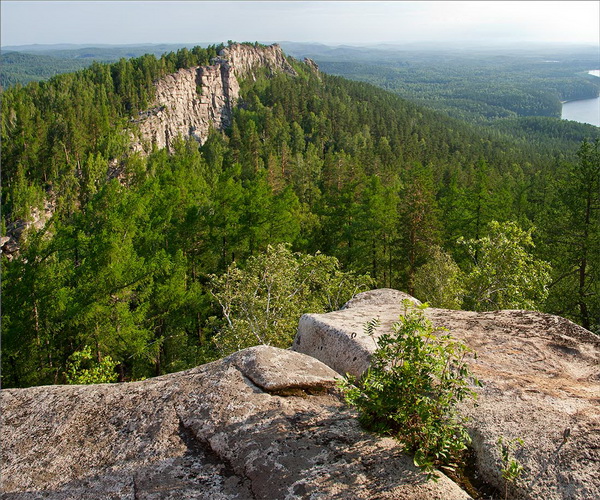 Photo by: varakusha
 From the top of the cliff in good weather you can see about a dozen lakes. But the most beautiful view is located at the foot of the mountain Lake Arakul.
 Photo by: IriSka
  Photo by: IriSka
 Archaeologists have found several sites of ancient people near the rocks (Bronze Age and Early Iron Age). Pay attention to the indentations found here and there on the rocks. According to one version, our distant ancestors performed sacrifice rituals and lit ritual fires in these stone bowls. The diameter of the stone bowls is about two meters, and the depth reaches one meter.
 Photo by: varakusha
  Photo by: varakusha
 In total, archaeologists discovered 13 archaeological sites in the vicinity of Arakul. The age of the finds varies from the Chalcolithic to the second half of the 19th century.
 Photo by: IriSka
  Photo by: IriSka
 A hike to the Arakul Shikhan and Lake Arakul is a good weekend route. There are many other interesting attractions in the surrounding area.
Mysterious places in Russia Shnurovozova Tatyana Vladimirovna
Shikhan-gora (Mountain Shaman's Oath, Samara region)
Shikhan Mountain
(Mountain Shaman's Oath, Samara region)
In the northeast of the Samara region, near the village of Bolshaya Yoga, there is a lonely and mysterious Mount Shikhan, about which numerous legends and tales still live among the people.
In appearance, the mountain looks like a huge hemispherical vault made of huge stones. Perhaps it arose during the glaciation era, when the glacier, moving south, brought with it several tons of stone blocks, and after the ice melted, the stones piled up into a mountain. However, scientists doubt that the glacier reached these latitudes.
According to another version, this stone mountain was created not by nature, but by human hands for ritual purposes and is made of wild stone. At the same time, local residents are convinced that the mountain is hollow inside, and if you hit it with a crowbar, a booming sound will be heard, like from a barrel, since inside the mountain consists of numerous caves in which snake people once lived, which is why the sound that it makes when a mountain hits it, they call it a snake hiss. Coming from nowhere, the snake people built themselves a separate huge snake house out of stones in the form of a mountain, but they quickly got bored with life on the mountain, and they made their way inside the mountain, and sealed all the exits to the outside. To protect the common house at the very top of the mountain, they settled their watchman, a huge shaitan, who lived in one of the lakes at the top of the mountain.
His appearance, according to local beliefs, was frightening: in his outline he resembled a man, but his head consisted of fire, and fiery tails were visible behind his body. However, for unknown reasons, the spirit of the mountain left its black lake and flew away, leaving the caves sealed. Later, according to local residents, an evil sorcerer began to live in these caves, followed by robbers.
After the founding of the village of Yoga near the mountain and the arrival of Christian beliefs in the Samara lands, the mountain, covered with dense forest, with springs flowing at the top flowing into a clear lake, became a local shrine; People came to the top of her head to pray in solitude, since the top of the mountain had mystical, wonderful, soul-pacifying properties. The springs were consecrated and named Bogoroditsky springs in honor of the Mother of God.
The word "shihany" translated from the Tatar language means "tent-shaped hill", or a single hill standing in the middle of the steppe. Almost every steppe region has its own shihan mountains - from the Urals to the Saratov region and Kazakhstan.
On major Christian holidays, religious processions were held on the mountain. And during a severe drought, a prayer service was held for rain, for which all the villagers and priests walked around the fields with icons, and then with bread and salt they went up to the Virgin Mary springs, lowered a tray with gifts onto a special prayer stone and served a prayer service for the granting of rain. The ritual procession ended under the mountain, where the second prayer service was read.
The consecrated lake was cleared of mud and plants every year, thanks to which the water in it remained clean and was considered healing.
However, after the October Revolution with the advent of atheism, the path to the mountain began to gradually become overgrown; only old people and pilgrims went to the prayer stone, and since the 1970s. the path to the top of the mountain was practically forgotten. The lake was covered with vegetation, frogs appeared in the water, and gradually the clear reservoir began to turn into a swamp. Later, wild boars that had escaped from the Orenburg forests settled on the mountain, and it was finally identified by local residents as an unkind and life-threatening place, the path to which was better to forget.
Since the mid-1980s. A strange mountain with many legends dedicated to it interested scientists, and they decided to check the anomaly of Shikhan Mountain. Arriving at the desired coordinates, they actually saw a forest-covered mountain made of huge stones. At the same time, many of them seemed to have melted, which suggested that the mountain attracts lightning during summer thunderstorms. This may have been caused by the presence of metal inside the caves or other unknown factors. After examining the mountain, the researchers noticed numerous narrow and deep tunnels through which air circulated, which suggested the presence of voids and caves inside the mountain. It was not possible to fully explore the mountain: most of the peak turned out to be swampy, and the forests were inhabited not only by herds of wild boars, but also by encephalitis ticks.
At the same time, not only the mountain was anomalous, the weather also behaved quite strangely: as soon as the researchers approached the mountain, the sunny and seemingly cloudless weather quickly gave way to cold, pouring rain. It can be assumed that this was an accident if the weather change had not occurred again - during the next attempt to climb to the top of the mountain and explore it.
Scientists had to retreat, since then no new research has been undertaken on this mountain, local residents do not go to the mountain, and no hiking trails have been laid there.
Shikhan Mountain continues to keep its secrets about the voids inside it and the secret of attracting huge amounts of lightning.
From the book Call of the Jaguar by Grof Stanislav From the book Gateway to the Future (collection) author Roerich Nikolai KonstantinovichMount Destined “A certain villager from Shanxi felt extremely unhappy. From his father he inherited land that was completely infertile. Most of it was in such a rocky hill, where even unpretentious sheep could not get food for themselves. True, grandfather once
From the book From Mystery to Mystery author Priyma AlexeyMOUNTAIN OF THE DEAD According to journalists from Sverdlovsk (present-day Yekaterinburg), in February 1959 a terrible tragedy occurred in the mountains of the Northern Urals. Under completely mysterious circumstances, ten well-trained soldiers died in the Otorten region.
From the book A Critical Study of the Chronology of the Ancient World. Bible. Volume 2 author Postnikov Mikhail MikhailovichMount Sinai “Interestingly, it has proven virtually impossible to even establish the location of the notorious Mount Sinai. The difficulty of its discovery is aggravated by the fact that the Bible often appears as the mountain where the revelation was given, not Sinai, but Horeb. If
From the book Agni Yoga. Sacred Signs (collection) author Roerich Elena IvanovnaWhite Mountain White Mountain, the Mountain that knew where the white water came from. The Mountain will send the stones of the Katun. They take down the stones of the white shores, they separate the stones of brother from brother. Katun is red with blood, there is a war going on. White Mountain, did you send the red stones? Where is your Belovodye? I’ll take the cedar staff,
From the book The Road Home author Zhikarentsev Vladimir VasilievichMoses, Mount Horeb and Mount Sinai First, God appeared to Moses on Mount Horeb in the form of a burning thorn bush - a burning bush. Horeb - hrv - on the contrary vrkh - top. God really is somewhere above, God himself is the Top/Mount Horeb. Moses met God when he was herding
From the book Sacred Geometry. Energy codes of harmony author Prokopenko IolantaThe Eye of Horus Wadjet is an ancient Egyptian symbol, representing a falcon's eye, knocked out of Horus during his fight with Set. Symbolized the moon, whose phases were explained by damage during the legendary battle. Represents various spheres of the world order, from the royal
From the book Mysterious Places of Russia author Shnurovozova Tatyana VladimirovnaZhiguli (Samara Luka, Samara Region) A small highland in the Samara Region with a name familiar to every Russian motorist is located near Togliatti, in the area of the largest bend of the Volga, which goes around the mountainous area. In the old days, this advantageous point
From the book Where did it come from, how the world was organized and protected author Nemirovsky Alexander IosifovichPata-Kabusya (“Flying Head”, Samara Region) In the north-west of the Samara region there is a small swampy area with low mountains and dense forest, in which, according to local beliefs, resides an evil spirit - the “Flying Head”, or Pata-Kabusya. At night she rests on
From the book Inner Light. Osho Meditation Calendar for 365 days author Rajneesh Bhagwan ShriMount Shoria (Kemerovo region) In the extreme south of the Kemerovo region, where the Sayan Mountains adjoin the Altai, and the high mountains are covered by impenetrable taiga, lies a mysterious and largely mysterious area called Mountain Shoria. It is here, according to numerous reports
From the book Safe Communication [Magical practices for protection from energy attacks] author Penzak ChristopherMount Bo-Dzhausa The border of the Primorsky and Khabarovsk territories runs along the most beautiful Sikhote-Alin ridge in the seaside with average heights of up to 1000 m. Among the low Far Eastern hills, the majestic peak of Bo-Dzhausa, unique in its beauty, stands out
From the book Places of Power on the Map of Russia author Suprunenko Yuri PavlovichMount Maura (Vologda Region) At first glance, Mount Maura does not strike a tourist in any way. It is quite low - only 185 m high, there are no unique historical buildings on it, and no unusual plants grow. Of course, a mountain densely covered with spruce forest and
From the author's bookRakshasa Mountain Inspired by the victory, Sugriva’s army prepared to storm the Rakshasa capital. Sections of the wall had already been distributed among the individual monkey tribes advanced to the front line. A signal was assigned at which the simultaneous
From the author's book311 Inner Mountain In complete silence and peace, when there is no movement in the mind, a person begins to feel like the top of a snowy, sky-high mountain. Mountains have always attracted meditators. There is something in the mountains... - silence, peace, absolute stillness, the feeling that
From the author's bookEye of Horus The Eye of Horus is another Egyptian symbol that is now used for protection. It is associated with Horus, the son of Isis and Osiris, although the symbol is sometimes called the eye of Ra, the solar creator god. It is believed that the eyes of Horus are the Sun and the Moon, and he himself is powerful
From the author's bookSamara region The outskirts of Samara are a continuous anomalous zone - so many miracles are observed here! For example, the head of the ufological organization in the city of Togliatti, Tatyana Makarova, claims that up to a hundred different anomalies are recorded there every year.
Mount Shikhan in Bashkiria is an amazing geological natural monument. This ancient formation consists of four components - Yurak-tau, Kush-tau, Shah-tau and Tra-tau. Isolated hills, forming a narrow chain, stretch for twenty kilometers along the river. White.
Wonders of nature
In ancient times, the territory of modern Bashkiria was occupied by the ocean. At that time, Mount Shihan was nothing more than a reef. And you can still see imprints made by mollusks on the hill. The accumulation of fossils became a kind of repository for a variety of representatives of the ancient organic world. Among them are sponges, corals, bryozoans, algae, echinoderms, foraminifera and brachiopods.
Yurak-tau
Mount Shikhan (Sterlitamak is nearby) is the remnant of a reef that was once part of the Lower Permian massif. It is attributed to the late Paleozoic. The approximate period of formation is about 230 million years ago. Mount Shihan has a cone-shaped shape. The slopes are quite steep - about twenty to thirty degrees, but they do not form rocky ledges. The lower part is covered with scree. At the base of the slope on the northern side there are springs, one of which is sulphurous. The length of Yurak-tau is 1000 m, width - 850 m. The height above ocean level is 338 meters, above soil level - 200 m, and above the Belaya River - 220 meters. At the foot is located about. Moksha.
Kush-tau
This Mount Shikhan is located three kilometers from Yurak-tau. It is 140 km from Ufa and 18 km from Sterlitamak. In shape it is a two-humped ridge, elongated from north to south. At the foot of the mountain there is a holiday home called “Shikhany”. The eastern slope is occupied by the slopes of the famous ski resort. Like other shihans in Bashkiria, Kush-tau is a remnant of the Lower Permian reef massif.

Shah-tau
This Mount Shikhan rises five kilometers from Sterlitamak. Its length is 1.3 kilometers. Shah-tau is extended towards the southwest. The absolute height until the start of the development process was 336 meters. The interest of researchers is attracted by large limestone ledges, where in the frozen rocks one can find shells of marine animals that died out millions of years ago, soaked in semi-liquid oil or tar.
The mountain's limestones are being mined to obtain raw materials produced by the Sterlitamak production association "Soda". When this process had not yet begun, broad-leaved maple and oak forests grew on the slopes on the north side.
As of 1975, the peak of “Tsar Mountain” (the literal translation of the name) became thirty-five meters lower. Currently, practically nothing remains of this shihan.
Tra-tau
This mountain is located eight kilometers south of Shakh-tau. In shape it is a regular truncated cone. The southwestern slope is very steep. This shihan is an unspoken symbol of the Ishimbay district. Since 1965, it has the status of Tra-tau, rising 280 meters above ground level. It is noteworthy that more than a hundred species of herbaceous plants grow in a relatively small area of the mountain. Small caves can be found in the upper parts of the western and southwestern slopes. At the foot is Lake Tugar-Salgan.
Yurmatians have long considered Tra-tau theirs. The territory around this shihan was considered forbidden for many centuries. It was there that all the most important rituals were held.

Beautiful legends
There are many legends about the ancient mountains, passed down from mouth to mouth for more than one generation. One of them tells us about the unrequited feelings that flared up among the horseman Ashak for the beautiful Agidel. For a long time, the young man tried to gain the favor of his beloved, but the girl did not pay attention to expensive gifts or confessions. In the end, Agidel secretly left her parents' house, never to see Ashak again. The news of this made the young man very angry. He rushed in pursuit of the shrew. When Ashak caught up with Agidel, he hit the girl painfully with a whip. The father of the young beauty, Ural, did not want anyone to raise a hand against his daughter. In order to protect his child, he turned Agidel into a river. When Ashak realized what he had done, he tore out his heart. Since then, at the site of the sad events, a thin river, like a young maiden, flows and four shikhans stand.
There are many other beliefs that tell about the incredible history of the origin of these mountains. Indeed, it is difficult to believe that such a miracle of nature appeared without the intervention of magical forces.

The result of painstaking work
What was once hidden in the depths of rocks can now be admired in the museum. It was discovered thanks to the efforts of Ivan Albertovich Skuin, a geologist who has been collecting the collection for more than twenty years. The museum is located in the quarry of Mount Shakh-tau. Most of all, tourists want to look at beautiful stones of different sizes and shapes. Analogues of this collection cannot be found anywhere else in the world. This museum attracts not only ordinary travelers, but also geologists. The latter are given the opportunity to study reefs of the Lower Permian period exposed on the earth's surface.
Recreation opportunities
Mount Shikhan forms a unique place. You can have a wonderful rest there either in a large company or in a close family circle by pitching a tent on one of the many suitable sites.
Mount Shikhan. Chelyabinsk region
This granite rock massif is located in the Middle Urals. The town of Verkhniy Ufaley is located nearby, and the Silach station is six kilometers away. Mount Shikhan was formed in the intermountain depression, stretching for two kilometers from north to south. The maximum width of the chain ranges from forty to fifty meters. Peak - Chamberlain (80 m).
The journey from Chelyabinsk to this natural monument will take about two and a half hours. Tourists are advised to stock up on repellents, as there are really a lot of mosquitoes in these places.

Conclusion
Mountains are unique creations of nature. They give us the purest air and offer us magnificent views. The massifs, which appeared millions of years ago, have not only aesthetic, but also practical value, becoming a source of production of various minerals, precious metals and much more.